Recent from talks
Acton, London
Knowledge base stats:
Talk channels stats:
Members stats:
Acton, London
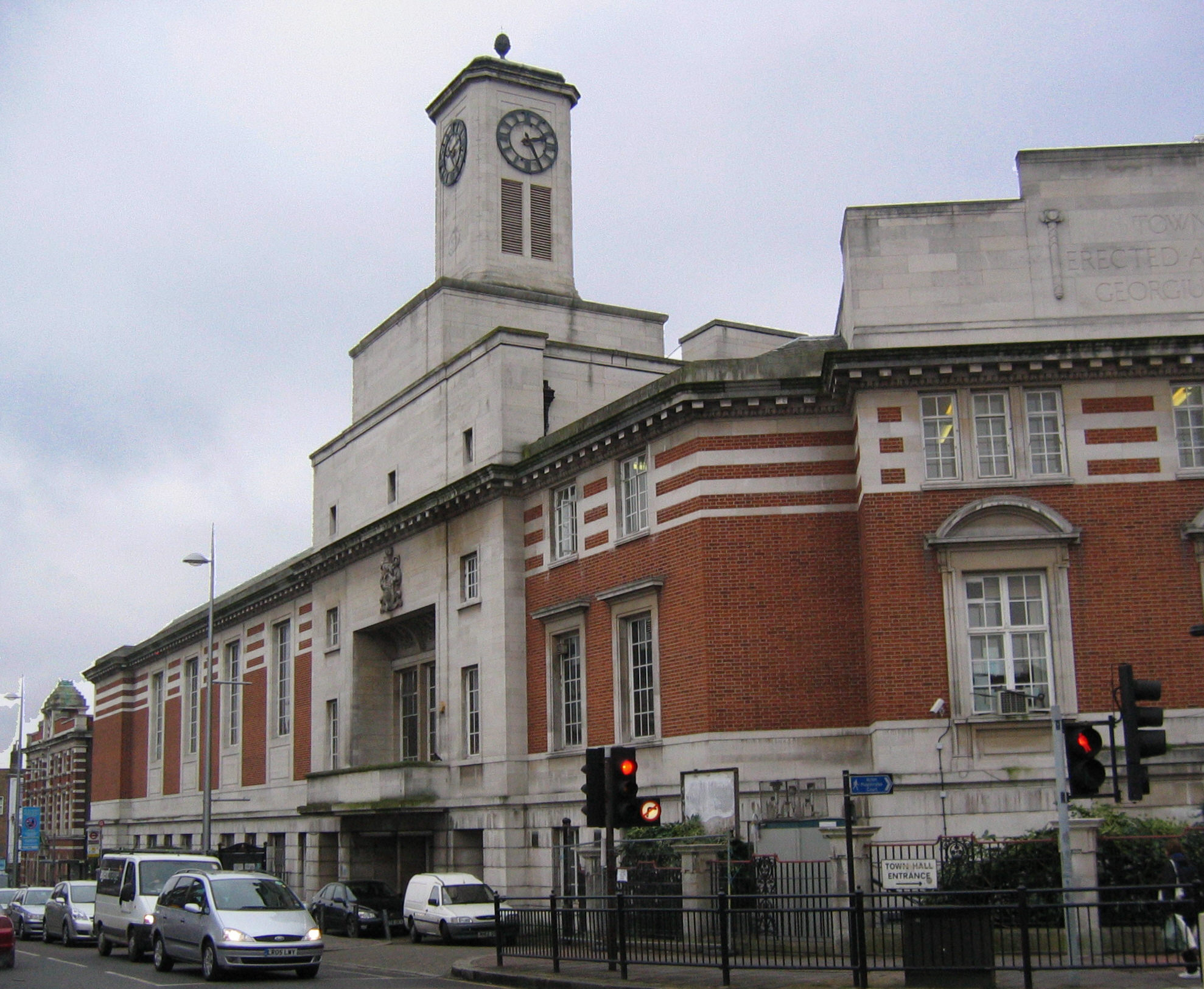
Acton (/ˈæktən/) is a town in West London, England, within the London Borough of Ealing. It is 6.1 miles (10 km) west of Charing Cross.
At the 2011 census, its four wards, East Acton, Acton Central, South Acton and Southfield, had a population of 62,480, a ten-year increase of 8,791 people. North Acton, West Acton, East Acton, South Acton, Acton Green, Acton Town, Acton Vale and Acton Central are all parts of Acton.
Acton means "oak farm" or "farm by oak trees", and is derived from the Old English āc (oak) and tūn (farm). Originally an ancient village, as London expanded, Acton was absorbed into the city. Since 1965, Acton equates to the east of the London Borough of Ealing, though some of East Acton is in the London Borough of Hammersmith and Fulham and a small portion of South Acton is in the London Borough of Hounslow.
Central Acton is synonymous with the hub of commerce and retail on the former main road between London and Oxford (the Uxbridge Road); a reminder of its history is in its inns, which in some cases date back to the late Tudor period as stopping places for travellers. Nowadays, the principal route linking London and Oxford (the A40 dual carriageway) bypasses central Acton, but passes through East Acton and North Acton.
Acton's name derives from the Old English words āc (oak) and tūn (enclosed garden, enclosure), meaning "a garden or a field enclosed by oaks". Later, in the Middle Ages tūn became a synonym for "farm" or "farm by oak trees". For several centuries, its name bore the prefix Church (hence Chirche Acton, Churche Acton, etc.) to distinguish it from the separate hamlet of East Acton.
A number of finds indicate prehistoric settlement in Acton. The earliest are a cluster of Upper Palaeolithic and Mesolithic flint cores, flakes and artefacts found mainly to the north of Churchfield Road. Around the Mill Hill Park area, a Neolithic axe, and a group of Bronze Age Deverel-Rimbury urns and cremated bone were found, along with an Iron Age pot shard. Iron Age coins were also found near Bollo Lane. The Roman period is represented by a ditch in the same area, and a hoard north of Springfield Gardens. In the Middle Ages the northern half of the parish was heavily wooded. Oaks and elms still stood along roads and hedgerows and in private grounds in the early 20th century, but most of the woodland had been cleared by the 17th century, even on the extensive Old Oak common.
Landholders figuring in county records were resident by 1222 and houses were recorded from the late 13th century. The main settlement, Church Acton or Acton town, lay slightly west of the centre of the parish along the highway to Oxford (Uxbridge Road) at the 5-mile post out of London. By 1380 some of the tenements, such as The Tabard and The Cock, along the south side of the road, were inns. The hamlet of East Acton, mentioned in 1294, consisted of farmhouses and cottages north and south of common land known as East Acton green by 1474.
Medieval settlement was mainly around the two hamlets. At Church Acton most of the farmhouses lay along the Oxford road or Horn Lane, with only a few outlying farms. Friars Place Farm at the north end of Horn Lane and the moated site to the west, occupied until the 15th century, were early farms. East of Friars Place farm were commons: Worton or Watton Green and Rush green in the 16th and 17th centuries, and Friars Place in the 18th century, where there was some settlement by 1664. To the north-west were Acton or Old Oak wells, known by 1613. In the parish's extreme south, a few farmhouses on the northern side of Acton common or Acton Green were mentioned as in Turnham Green until the 19th century and were linked more closely with that village than with Acton. Gregories, mentioned in 1551 as a copyhold tenement with 30 a. near Bollo Lane and the Brentford high road, probably lay in Acton.
Hub AI
Acton, London AI simulator
(@Acton, London_simulator)
Acton, London
Acton (/ˈæktən/) is a town in West London, England, within the London Borough of Ealing. It is 6.1 miles (10 km) west of Charing Cross.
At the 2011 census, its four wards, East Acton, Acton Central, South Acton and Southfield, had a population of 62,480, a ten-year increase of 8,791 people. North Acton, West Acton, East Acton, South Acton, Acton Green, Acton Town, Acton Vale and Acton Central are all parts of Acton.
Acton means "oak farm" or "farm by oak trees", and is derived from the Old English āc (oak) and tūn (farm). Originally an ancient village, as London expanded, Acton was absorbed into the city. Since 1965, Acton equates to the east of the London Borough of Ealing, though some of East Acton is in the London Borough of Hammersmith and Fulham and a small portion of South Acton is in the London Borough of Hounslow.
Central Acton is synonymous with the hub of commerce and retail on the former main road between London and Oxford (the Uxbridge Road); a reminder of its history is in its inns, which in some cases date back to the late Tudor period as stopping places for travellers. Nowadays, the principal route linking London and Oxford (the A40 dual carriageway) bypasses central Acton, but passes through East Acton and North Acton.
Acton's name derives from the Old English words āc (oak) and tūn (enclosed garden, enclosure), meaning "a garden or a field enclosed by oaks". Later, in the Middle Ages tūn became a synonym for "farm" or "farm by oak trees". For several centuries, its name bore the prefix Church (hence Chirche Acton, Churche Acton, etc.) to distinguish it from the separate hamlet of East Acton.
A number of finds indicate prehistoric settlement in Acton. The earliest are a cluster of Upper Palaeolithic and Mesolithic flint cores, flakes and artefacts found mainly to the north of Churchfield Road. Around the Mill Hill Park area, a Neolithic axe, and a group of Bronze Age Deverel-Rimbury urns and cremated bone were found, along with an Iron Age pot shard. Iron Age coins were also found near Bollo Lane. The Roman period is represented by a ditch in the same area, and a hoard north of Springfield Gardens. In the Middle Ages the northern half of the parish was heavily wooded. Oaks and elms still stood along roads and hedgerows and in private grounds in the early 20th century, but most of the woodland had been cleared by the 17th century, even on the extensive Old Oak common.
Landholders figuring in county records were resident by 1222 and houses were recorded from the late 13th century. The main settlement, Church Acton or Acton town, lay slightly west of the centre of the parish along the highway to Oxford (Uxbridge Road) at the 5-mile post out of London. By 1380 some of the tenements, such as The Tabard and The Cock, along the south side of the road, were inns. The hamlet of East Acton, mentioned in 1294, consisted of farmhouses and cottages north and south of common land known as East Acton green by 1474.
Medieval settlement was mainly around the two hamlets. At Church Acton most of the farmhouses lay along the Oxford road or Horn Lane, with only a few outlying farms. Friars Place Farm at the north end of Horn Lane and the moated site to the west, occupied until the 15th century, were early farms. East of Friars Place farm were commons: Worton or Watton Green and Rush green in the 16th and 17th centuries, and Friars Place in the 18th century, where there was some settlement by 1664. To the north-west were Acton or Old Oak wells, known by 1613. In the parish's extreme south, a few farmhouses on the northern side of Acton common or Acton Green were mentioned as in Turnham Green until the 19th century and were linked more closely with that village than with Acton. Gregories, mentioned in 1551 as a copyhold tenement with 30 a. near Bollo Lane and the Brentford high road, probably lay in Acton.
Recent media