Community hub
Community hub
Recent from talks
Knowledge base stats:
Talk channels stats:
Members stats:
Cresap's War
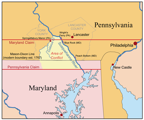
Cresap's War (also known as the Conojocular War, from the Conejohela Valley where it was mainly located along the south bank) was a border conflict between Pennsylvania and Maryland fought in the 1730s. Hostilities erupted in 1730 with a series of violent incidents prompted by disputes over property rights and law enforcement. The conflict escalated through the first half of the decade, culminating in the deployment of military forces by Maryland in 1736 and by Pennsylvania in 1737. The armed phase of the conflict ended in May 1738 with the intervention of King George II, who compelled the negotiation of a ceasefire. A final settlement was not achieved until 1767 when the Mason–Dixon line was recognized as the permanent boundary between the two colonies.
Pennsylvania's Charter (1681) specified that the colony was bounded "on the South by a Circle drawne at twelve miles [19 km] distance from New Castle Northward and Westward unto the beginning of the fortieth degree of Northern Latitude, and then by a streight Line Westward...." Later surveys established that the town of New Castle in fact lay a full 25 miles (40 km) south of the fortieth parallel, setting the stage for a boundary dispute. Maryland insisted that the boundary be drawn at the fortieth parallel as specified in the Charter, while Pennsylvania proposed that it be drawn by an elaborate method which purported to compensate for the geographic misunderstanding on which the Charter had been based. This proposal placed the boundary near 39 36', creating a 28-mile (45 km) wide strip of disputed territory.
Because the fortieth parallel lay north of the city of Philadelphia, Maryland pressed its claim most seriously in the sparsely inhabited lands west of the Susquehanna River. By the late 1710s, rumors had begun to reach the Pennsylvania Assembly that Maryland was planning to establish settlements in the disputed area near the river. In response, Pennsylvania attempted to bolster its claim to the territory by organizing a proprietorial manor along the Codorus Creek, just west of the river, in 1722. This action prompted a crisis in relations between the two colonies, leading to a royal proclamation in 1724 which prohibited both colonies from establishing new settlements in the area until a boundary had been surveyed. However, the two sides failed to reach agreement on the location of the boundary, and unauthorized settlement recommenced within a short time.
In 1726, the English-born Quaker leader John Wright and two associates with their families settled near the river. They had been coming to the birding swarms along the Conejohela Flats since 1724 and had made friends and converted an appreciable number of Indians, most by working their way through the marshy shallows on the opposite (west or right) bank of the Susquehanna. Sometime after building a house and planting a farm, probably with the help of their Indian friends in the second year there, Wright ended up building two medium-to-large dugout canoes kept and tied off on either bank, creating the seeds of an ad hoc passenger ferry business for those desiring to cross. A few settlers moved across, settling mainly a few miles to the north along Codorus Creek and Kreutz Creek, but traffic grew sufficient to officially apply for a ferry license in 1730.[citation needed]
Settlement picked up significantly that year, probably due to the promise of regular ferry service across the Susquehanna, greatly easing transportation difficulties, but the inflow alarmed Lord Baltimore with respect to his ability to assert control and collect incomes from the disputed area. By midsummer of 1730, a number of Pennsylvania Dutch settler families had crossed the river and taken up residence. Determined to counter this development, a Marylander, Thomas Cresap, opened a second ferry service at Blue Rock, about four miles (6 km) south of Wright's Ferry near current day Washington Boro, Pennsylvania.[citation needed]
Owing to the royal proclamation of 1724, the Pennsylvania settlers did not have clear title to the lands that they occupied. Apparently in defiance of the proclamation, Maryland granted Cresap title to 500 acres (2 km2) along the west bank of the river, much of which was already inhabited. Cresap began to act as a land agent, persuading many Pennsylvania Dutch to purchase their farms from him, thus obtaining title under Maryland law, and began collecting quit-rents (an early form of property tax) for Maryland. In response, Pennsylvania authorities at Wright's Ferry began to issue "tickets" to new settlers which, while not granting immediate title, promised to award title as soon as the area was officially opened to settlement.
Sometime in late October, 1730, Cresap was attacked on his ferry boat by two Pennsylvanians. According to Cresap's Maryland deposition, Cresap and one of his workmen were hailed by the Pennsylvanians and began rowing the two men from the east to the west. Sixty yards into the trip, the Pennsylvanians turned their guns on the Marylanders and a fight ensued with Cresap attempting to use the oars to defend himself. After a short struggle, both Marylanders ended up in the water, holding on to the boat to keep from drowning. The Pennsylvanians tried to force Cresap to let go of the boat, and when Cresap asked if they intended to murder him, one swore that he did. Cresap eventually escaped when the boat drifted to shallow water near a large rock where Cresap was stranded for several hours until rescued by a friendly Indian.
It would become clear in later testimony that the target of the attack was actually Cresap's workman who was wanted by a Lancaster county landowner for reasons not entirely clear (possibly debts). This workman was captured by the Pennsylvanians and carried forcibly away.
Hub AI
Cresap's War AI simulator
(@Cresap's War_simulator)
Cresap's War
Cresap's War (also known as the Conojocular War, from the Conejohela Valley where it was mainly located along the south bank) was a border conflict between Pennsylvania and Maryland fought in the 1730s. Hostilities erupted in 1730 with a series of violent incidents prompted by disputes over property rights and law enforcement. The conflict escalated through the first half of the decade, culminating in the deployment of military forces by Maryland in 1736 and by Pennsylvania in 1737. The armed phase of the conflict ended in May 1738 with the intervention of King George II, who compelled the negotiation of a ceasefire. A final settlement was not achieved until 1767 when the Mason–Dixon line was recognized as the permanent boundary between the two colonies.
Pennsylvania's Charter (1681) specified that the colony was bounded "on the South by a Circle drawne at twelve miles [19 km] distance from New Castle Northward and Westward unto the beginning of the fortieth degree of Northern Latitude, and then by a streight Line Westward...." Later surveys established that the town of New Castle in fact lay a full 25 miles (40 km) south of the fortieth parallel, setting the stage for a boundary dispute. Maryland insisted that the boundary be drawn at the fortieth parallel as specified in the Charter, while Pennsylvania proposed that it be drawn by an elaborate method which purported to compensate for the geographic misunderstanding on which the Charter had been based. This proposal placed the boundary near 39 36', creating a 28-mile (45 km) wide strip of disputed territory.
Because the fortieth parallel lay north of the city of Philadelphia, Maryland pressed its claim most seriously in the sparsely inhabited lands west of the Susquehanna River. By the late 1710s, rumors had begun to reach the Pennsylvania Assembly that Maryland was planning to establish settlements in the disputed area near the river. In response, Pennsylvania attempted to bolster its claim to the territory by organizing a proprietorial manor along the Codorus Creek, just west of the river, in 1722. This action prompted a crisis in relations between the two colonies, leading to a royal proclamation in 1724 which prohibited both colonies from establishing new settlements in the area until a boundary had been surveyed. However, the two sides failed to reach agreement on the location of the boundary, and unauthorized settlement recommenced within a short time.
In 1726, the English-born Quaker leader John Wright and two associates with their families settled near the river. They had been coming to the birding swarms along the Conejohela Flats since 1724 and had made friends and converted an appreciable number of Indians, most by working their way through the marshy shallows on the opposite (west or right) bank of the Susquehanna. Sometime after building a house and planting a farm, probably with the help of their Indian friends in the second year there, Wright ended up building two medium-to-large dugout canoes kept and tied off on either bank, creating the seeds of an ad hoc passenger ferry business for those desiring to cross. A few settlers moved across, settling mainly a few miles to the north along Codorus Creek and Kreutz Creek, but traffic grew sufficient to officially apply for a ferry license in 1730.[citation needed]
Settlement picked up significantly that year, probably due to the promise of regular ferry service across the Susquehanna, greatly easing transportation difficulties, but the inflow alarmed Lord Baltimore with respect to his ability to assert control and collect incomes from the disputed area. By midsummer of 1730, a number of Pennsylvania Dutch settler families had crossed the river and taken up residence. Determined to counter this development, a Marylander, Thomas Cresap, opened a second ferry service at Blue Rock, about four miles (6 km) south of Wright's Ferry near current day Washington Boro, Pennsylvania.[citation needed]
Owing to the royal proclamation of 1724, the Pennsylvania settlers did not have clear title to the lands that they occupied. Apparently in defiance of the proclamation, Maryland granted Cresap title to 500 acres (2 km2) along the west bank of the river, much of which was already inhabited. Cresap began to act as a land agent, persuading many Pennsylvania Dutch to purchase their farms from him, thus obtaining title under Maryland law, and began collecting quit-rents (an early form of property tax) for Maryland. In response, Pennsylvania authorities at Wright's Ferry began to issue "tickets" to new settlers which, while not granting immediate title, promised to award title as soon as the area was officially opened to settlement.
Sometime in late October, 1730, Cresap was attacked on his ferry boat by two Pennsylvanians. According to Cresap's Maryland deposition, Cresap and one of his workmen were hailed by the Pennsylvanians and began rowing the two men from the east to the west. Sixty yards into the trip, the Pennsylvanians turned their guns on the Marylanders and a fight ensued with Cresap attempting to use the oars to defend himself. After a short struggle, both Marylanders ended up in the water, holding on to the boat to keep from drowning. The Pennsylvanians tried to force Cresap to let go of the boat, and when Cresap asked if they intended to murder him, one swore that he did. Cresap eventually escaped when the boat drifted to shallow water near a large rock where Cresap was stranded for several hours until rescued by a friendly Indian.
It would become clear in later testimony that the target of the attack was actually Cresap's workman who was wanted by a Lancaster county landowner for reasons not entirely clear (possibly debts). This workman was captured by the Pennsylvanians and carried forcibly away.