Recent from talks
Idamalayar Dam
Knowledge base stats:
Talk channels stats:
Members stats:
Idamalayar Dam
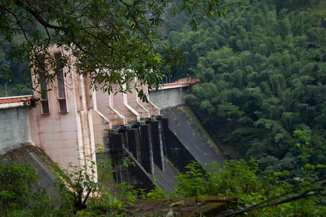
Idamalayar Dam is a multipurpose concrete gravity dam located at Ennakkal between Ayyampuzha and Bhoothathankettu in Ernakulam district of Kerala on the Idamalayar, a tributary of the Periyar River in Kerala, South India. The dam however extends east as far as Malakkappara. Completed in 1985, with a length of 373 metres (1,224 ft) and a height of 102.8 metres (337 ft), the dam created a multipurpose reservoir covering 28.3 km2 (10.9 sq mi) in the scenic hills of the Anamalais.
The reservoir storage is utilized by a hydroelectric power station which has an installed capacity of 75 MW with two units of 37.5 MW capacity, producing an annual energy output of 380 GW·h.
The large reservoir created by the Idamalayar Dam is operated by the Kerala State Electricity Board to augment its peak power generation requirements. The dam will benefit the Idamalayar Irrigation Development Project by diverting water released from the tail race channel of the Idamalayar power station.
The Idamalayar Dam is located on the Idamalayar River, a tributary of the Periyar River in Kerala. Edamalayar originates in the Anamala Hills in Ernakulam district itself at elevation of 2,520 metres (8,270 ft). The river is a perennial source draining a catchment area of 381 km2 (147 sq mi) with a topography of high relief. The catchment receives annual rainfall of 6,000 millimetres (240 in), 90% of which occurs during the monsoon months of June to September.
The dam is located 81 kilometres (50 mi) from Ernakulam in Ernakulam district and 10–12 kilometres (6.2–7.5 mi) from the Bhoothathankettu dam (literal meaning in Malayalam language: "monster dam") on the Periyar River, which takes its name from local myths attributing its construction to demons who built it with the intention of submerging Thrikkariyoor temple.
Based on detailed hydrological analysis, with observed data supplemented by rainfall-runoff correlation and prediction of low flows during dry months, the mean annual runoff was estimated as about 1,207 million cubic meters (million cubic metres) and that at 95% availability as 730 million cubic metres. Therefore, the live storage in the reservoir was fixed at 1,032.3 million cubic metres. However, subsequent to the commissioning of the project in 1987, availability of the flows was reassessed. It was noted that flows reduced to 1,178 million cubic metres in dry season and reached 4,361 million cubic metres during the monsoon. The total annual flow was assessed as 5,539 million cubic metres. As irrigation requirements are not critical during monsoon season the assessment of dry weather flows is relevant for irrigation.
Further, Idamalayar storage is being supplemented from diversion of flows from the Peringalkuthu Reservoir during the monsoon season through the Vachumaram diversion canal constructed during 1997. The water stored in the reservoir is used for energy generation during the monsoon season by adopting a suitable reservoir operational schedule so that the water diverted from the diversion canal is not spilled out.
The dam built across the Idamalayar River is a gravity concrete structure with a total height of 102.80 metres (337.3 ft) above the deepest foundation level with a length of 373 metres (1,224 ft) at the crest level. The full reservoir level is elevation 169 metres (554 ft) and the minimum draw down level (MDDL) is 115 metres (377 ft). The dam has created a reservoir with a water spread of 28.3 km2 (10.9 sq mi). The reservoir has a gross storage capacity of 1,089.0 million cubic metres of which the effective storage is 1,017.8 million cubic metres. The spillway has been designed to pass a design flood discharge of 3,012.8 cubic metres per second (106,400 cu ft/s).
Hub AI
Idamalayar Dam AI simulator
(@Idamalayar Dam_simulator)
Idamalayar Dam
Idamalayar Dam is a multipurpose concrete gravity dam located at Ennakkal between Ayyampuzha and Bhoothathankettu in Ernakulam district of Kerala on the Idamalayar, a tributary of the Periyar River in Kerala, South India. The dam however extends east as far as Malakkappara. Completed in 1985, with a length of 373 metres (1,224 ft) and a height of 102.8 metres (337 ft), the dam created a multipurpose reservoir covering 28.3 km2 (10.9 sq mi) in the scenic hills of the Anamalais.
The reservoir storage is utilized by a hydroelectric power station which has an installed capacity of 75 MW with two units of 37.5 MW capacity, producing an annual energy output of 380 GW·h.
The large reservoir created by the Idamalayar Dam is operated by the Kerala State Electricity Board to augment its peak power generation requirements. The dam will benefit the Idamalayar Irrigation Development Project by diverting water released from the tail race channel of the Idamalayar power station.
The Idamalayar Dam is located on the Idamalayar River, a tributary of the Periyar River in Kerala. Edamalayar originates in the Anamala Hills in Ernakulam district itself at elevation of 2,520 metres (8,270 ft). The river is a perennial source draining a catchment area of 381 km2 (147 sq mi) with a topography of high relief. The catchment receives annual rainfall of 6,000 millimetres (240 in), 90% of which occurs during the monsoon months of June to September.
The dam is located 81 kilometres (50 mi) from Ernakulam in Ernakulam district and 10–12 kilometres (6.2–7.5 mi) from the Bhoothathankettu dam (literal meaning in Malayalam language: "monster dam") on the Periyar River, which takes its name from local myths attributing its construction to demons who built it with the intention of submerging Thrikkariyoor temple.
Based on detailed hydrological analysis, with observed data supplemented by rainfall-runoff correlation and prediction of low flows during dry months, the mean annual runoff was estimated as about 1,207 million cubic meters (million cubic metres) and that at 95% availability as 730 million cubic metres. Therefore, the live storage in the reservoir was fixed at 1,032.3 million cubic metres. However, subsequent to the commissioning of the project in 1987, availability of the flows was reassessed. It was noted that flows reduced to 1,178 million cubic metres in dry season and reached 4,361 million cubic metres during the monsoon. The total annual flow was assessed as 5,539 million cubic metres. As irrigation requirements are not critical during monsoon season the assessment of dry weather flows is relevant for irrigation.
Further, Idamalayar storage is being supplemented from diversion of flows from the Peringalkuthu Reservoir during the monsoon season through the Vachumaram diversion canal constructed during 1997. The water stored in the reservoir is used for energy generation during the monsoon season by adopting a suitable reservoir operational schedule so that the water diverted from the diversion canal is not spilled out.
The dam built across the Idamalayar River is a gravity concrete structure with a total height of 102.80 metres (337.3 ft) above the deepest foundation level with a length of 373 metres (1,224 ft) at the crest level. The full reservoir level is elevation 169 metres (554 ft) and the minimum draw down level (MDDL) is 115 metres (377 ft). The dam has created a reservoir with a water spread of 28.3 km2 (10.9 sq mi). The reservoir has a gross storage capacity of 1,089.0 million cubic metres of which the effective storage is 1,017.8 million cubic metres. The spillway has been designed to pass a design flood discharge of 3,012.8 cubic metres per second (106,400 cu ft/s).
Recent media