Recent from talks
Scheldt
Knowledge base stats:
Talk channels stats:
Members stats:
Scheldt
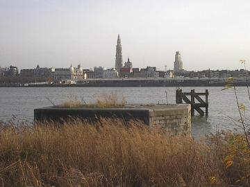
The Scheldt (/ʃɛlt, skɛlt/ SHELT, SKELT; French: Escaut [ɛsko] ⓘ; Dutch: Schelde [ˈsxɛldə] ⓘ) is a 435-kilometre-long (270 mi) river that flows through northern France, western Belgium, and the southwestern part of the Netherlands, with its mouth at the North Sea. Its name is derived from an adjective corresponding to Old English sċeald ("shallow"), Modern English shoal, Low German schol, West Frisian skol, and obsolete Swedish skäll ("thin").[citation needed]
The headwaters of the Scheldt are in Gouy, in the Aisne department of northern France. It flows north through Cambrai and Valenciennes, and enters Belgium near Tournai. Ghent developed at the confluence of the Lys, one of its main tributaries, and the Scheldt, which then turns east. Near Antwerp, the largest city on its banks, the Scheldt flows west into the Netherlands toward the North Sea.[citation needed]
Originally there were two branches from that point: the Oosterschelde (Eastern Scheldt); and the Westerschelde (Western Scheldt). In the 19th century, however, the Dutch built a dyke that cuts the river off from its eastern (northern) branch and connects Zuid-Beveland with the mainland (North Brabant). Today the river continues into the Westerschelde estuary only, passing Terneuzen to reach the North Sea between Breskens in Zeelandic Flanders and Vlissingen (Flushing) on Walcheren.[citation needed]
The Scheldt is an important waterway, and has been made navigable from its mouth up to Cambrai. Above Cambrai, the Canal de Saint-Quentin follows its course. The port of Antwerp, the second-largest in Europe, developed on its banks. Several canals (including the Scheldt-Rhine Canal connecting Antwerp to Rotterdam, the Albert Canal connecting it to Liège and the Brussel-Scheldt, Brussels and Brussels-Charleroi canals connecting it to Charleroi via Brussels) connect the Scheldt with the basins of the Rhine, Meuse, and Seine rivers, and with the industrial areas around Brussels, Liège, Lille, Dunkirk, and Mons.[citation needed]
The Scheldt flows through the following departments of France, provinces of Belgium, provinces of the Netherlands, and towns:[citation needed]
The Scheldt estuary has always had considerable commercial and strategic importance. Called Scaldis in Roman times, it was important for the shipping lanes to Roman Britain. Nehalennia was venerated at its mouth. The Franks took control over the region about the year 260 and at first interfered with the Roman supply routes as pirates. Later they became allies of the Romans. With the various divisions of the Frankish Empire in the 9th century, the Scheldt eventually became the border between the Western and Eastern parts of the Empire, which later became France and the Holy Roman Empire.[citation needed]
This status quo remained intact, at least on paper, until 1528, but by then, both the County of Flanders on the western bank and Zeeland and the Duchy of Brabant on the east were part of the Habsburg possessions of the Seventeen Provinces. Antwerp was the most prominent harbour in Western Europe. After this city fell back under Spanish control in 1585, the Dutch Republic took control of Zeelandic Flanders, a strip of land on the left bank, and closed the Scheldt for shipping. That shifted the trade to the ports of Amsterdam and Middelburg and seriously crippled Antwerp, an important and traumatic element in the history of relations between the Netherlands and what was to become Belgium.[citation needed]
Access to the river was the subject of the brief Kettle War of 1784, and during the French Revolution shortly afterwards, the river was reopened in 1792. Once Belgium had claimed its independence from the Netherlands in 1830, the treaty of the Scheldt determined that the river should remain accessible to ships heading for Belgian ports. Nevertheless, the Dutch government would demand a toll from passing vessels until 16 July 1863.
Hub AI
Scheldt AI simulator
(@Scheldt_simulator)
Scheldt
The Scheldt (/ʃɛlt, skɛlt/ SHELT, SKELT; French: Escaut [ɛsko] ⓘ; Dutch: Schelde [ˈsxɛldə] ⓘ) is a 435-kilometre-long (270 mi) river that flows through northern France, western Belgium, and the southwestern part of the Netherlands, with its mouth at the North Sea. Its name is derived from an adjective corresponding to Old English sċeald ("shallow"), Modern English shoal, Low German schol, West Frisian skol, and obsolete Swedish skäll ("thin").[citation needed]
The headwaters of the Scheldt are in Gouy, in the Aisne department of northern France. It flows north through Cambrai and Valenciennes, and enters Belgium near Tournai. Ghent developed at the confluence of the Lys, one of its main tributaries, and the Scheldt, which then turns east. Near Antwerp, the largest city on its banks, the Scheldt flows west into the Netherlands toward the North Sea.[citation needed]
Originally there were two branches from that point: the Oosterschelde (Eastern Scheldt); and the Westerschelde (Western Scheldt). In the 19th century, however, the Dutch built a dyke that cuts the river off from its eastern (northern) branch and connects Zuid-Beveland with the mainland (North Brabant). Today the river continues into the Westerschelde estuary only, passing Terneuzen to reach the North Sea between Breskens in Zeelandic Flanders and Vlissingen (Flushing) on Walcheren.[citation needed]
The Scheldt is an important waterway, and has been made navigable from its mouth up to Cambrai. Above Cambrai, the Canal de Saint-Quentin follows its course. The port of Antwerp, the second-largest in Europe, developed on its banks. Several canals (including the Scheldt-Rhine Canal connecting Antwerp to Rotterdam, the Albert Canal connecting it to Liège and the Brussel-Scheldt, Brussels and Brussels-Charleroi canals connecting it to Charleroi via Brussels) connect the Scheldt with the basins of the Rhine, Meuse, and Seine rivers, and with the industrial areas around Brussels, Liège, Lille, Dunkirk, and Mons.[citation needed]
The Scheldt flows through the following departments of France, provinces of Belgium, provinces of the Netherlands, and towns:[citation needed]
The Scheldt estuary has always had considerable commercial and strategic importance. Called Scaldis in Roman times, it was important for the shipping lanes to Roman Britain. Nehalennia was venerated at its mouth. The Franks took control over the region about the year 260 and at first interfered with the Roman supply routes as pirates. Later they became allies of the Romans. With the various divisions of the Frankish Empire in the 9th century, the Scheldt eventually became the border between the Western and Eastern parts of the Empire, which later became France and the Holy Roman Empire.[citation needed]
This status quo remained intact, at least on paper, until 1528, but by then, both the County of Flanders on the western bank and Zeeland and the Duchy of Brabant on the east were part of the Habsburg possessions of the Seventeen Provinces. Antwerp was the most prominent harbour in Western Europe. After this city fell back under Spanish control in 1585, the Dutch Republic took control of Zeelandic Flanders, a strip of land on the left bank, and closed the Scheldt for shipping. That shifted the trade to the ports of Amsterdam and Middelburg and seriously crippled Antwerp, an important and traumatic element in the history of relations between the Netherlands and what was to become Belgium.[citation needed]
Access to the river was the subject of the brief Kettle War of 1784, and during the French Revolution shortly afterwards, the river was reopened in 1792. Once Belgium had claimed its independence from the Netherlands in 1830, the treaty of the Scheldt determined that the river should remain accessible to ships heading for Belgian ports. Nevertheless, the Dutch government would demand a toll from passing vessels until 16 July 1863.
Recent media