Hubbry Logo
search
logo
1987462

Solomon Sea

logo
Community Hub0 Subscribers
Read side by side
from Wikipedia

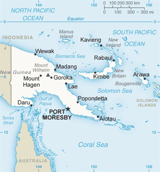
The Solomon Sea is a sea located within the Pacific Ocean. It lies between Papua New Guinea and Solomon Islands. Many major battles were fought there during World War II.

Key Information

Extent

[edit]

The International Hydrographic Organization defines the limits of the Solomon Sea as follows:[1]

On the Northwest. By the Southeast limit of Bismarck Sea [A line from the Southern point of New Ireland along the parallel of 4°50' South to the coast of New Britain, along its Northern coast and thence a line from its Western extreme through the Northern point of Umboi Island to Teliata Point, New Guinea (5°55′S 147°24′E / 5.917°S 147.400°E / -5.917; 147.400)].

On the Northeast. By a line from the Southern point of New Ireland to the North point of Buka Island, through this island to the Northwest point of Bougainville Island, along the Southern coasts of Bougainville, Choisel [Choiseul], Ysabel [Santa Isabel], Malaita and San Cristobal [Makira] Islands.

On the South. The Northern limit of the Coral Sea between San Cristobal Island, the Solomon Islands, and Gado-Gadoa Island, off the Southeast extreme of New Guinea [Gado-Gadoa Island near its Southeastern extreme (10°38′S 150°34′E / 10.633°S 150.567°E / -10.633; 150.567), down this meridian to the 100-fathom [600 ft; 183 m] line and thence along the Southern edges of Uluma (Suckling) Reef and those extending to the Eastward as far as the Southeast point of Lawik Reef (11°43.5′S 153°56.5′E / 11.7250°S 153.9417°E / -11.7250; 153.9417) off Tagula Island [Vanatinai], thence a line to the Southern extreme of Rennell Island and from its Eastern point to Cape Surville, the Eastern extreme of San Cristobal Island].

On the Southwest. By the coast of New Guinea and a line from its Southeasternmost point through the Louisiade Archipelago to Rossel Island.

Etymology

[edit]

The Solomon Sea is named after the Solomon Islands. These islands received their name "Islas Salomón" from the legend of the biblical land of Ophir — fabled as the source of King Solomon's wealth which was hoped to be discovered, in the first 1568 voyage by their discoverer Spanish navigator Álvaro de Mendaña de Neira. They were so named after his voyage when it was mapped.[2]

Deepest point

[edit]

The Solomon Sea roughly corresponds with the Solomon Sea Plate, a tectonic feature,[3] and includes the New Britain Trench, in the New Britain subduction zone, which reaches its maximum depth at 29,988 feet (9,140 m) below sea level in the Planet Deep.[4]

References

[edit]
[edit]
Revisions and contributorsEdit on WikipediaRead on Wikipedia
from Grokipedia
The Solomon Sea is a semi-enclosed marginal sea of the southwestern tropical Pacific Ocean, positioned at the western boundary of the equatorial Southwest Pacific between Papua New Guinea to the west and the Solomon Islands to the east.[1] It spans a surface area of 720,000 square kilometers (7.2 × 10¹¹ m²) and features complex topography with numerous islands, archipelagos, and straits that define its boundaries, including the Vitiaz Strait to the northwest, Solomon Strait and St. George's Channel to the east, and a southern opening toward the Coral Sea.[1] According to International Hydrographic Organization (IHO) limits, the sea extends from approximately 11°53'S to 4°50'S latitude and 146°57'E to 162°21'E longitude, encompassing key features such as the Louisiade Archipelago, New Britain, New Ireland, Bougainville, and the Trobriand Islands.[2] The Solomon Sea plays a critical role in regional ocean circulation as a conduit for the South Pacific low-latitude western boundary currents, including the New Guinea Coastal Undercurrent, which transports subtropical waters equatorward through its straits and basins at depths from the surface to over 1,400 meters.[1] Its waters exhibit high mesoscale eddy activity and variability influenced by El Niño-Southern Oscillation (ENSO) cycles, with transport volumes fluctuating significantly—reaching up to 20–30 Sverdrups during El Niño events—contributing to the broader Pacific warm pool dynamics.[3] Ecologically, the sea is part of the Coral Triangle and supports diverse marine biodiversity, including coral reefs and pelagic species, though it faces pressures from climate change, overfishing, and pollution in its coastal zones.[1][4] Historically, the Solomon Sea gained prominence during World War II as a pivotal battleground in the Allied campaign against Japanese forces, particularly through the Guadalcanal Campaign (1942–1943), which marked the first major U.S. offensive in the Pacific theater and involved intense naval engagements across its waters and surrounding islands.[5] These operations, including amphibious landings on Guadalcanal and Tulagi, resulted in significant naval losses and shifted momentum toward the Allies, securing vital sea lanes in the South Pacific.[5] Today, the region remains strategically important for international shipping routes connecting Australia, New Zealand, and Asia, while ongoing oceanographic research highlights its role in global climate regulation.[3]

Geography

Location and Extent

The Solomon Sea is a semi-enclosed sea situated at the western boundary of the equatorial Southwest Pacific Ocean, positioned between Papua New Guinea and the Solomon Islands.[1] It forms part of the broader South Pacific Ocean and is recognized as a distinct IHO sea area.[2] The sea's boundaries are precisely defined by the International Hydrographic Organization. To the northwest, it is delimited by the southeastern limit of the Bismarck Sea. The northeastern boundary follows a line from the southern point of New Ireland to the northern point of Buka Island, continuing through Buka to the northwest point of Bougainville Island, and then along the southern coasts of Bougainville, Choiseul, Ysabel, Malaita, and San Cristobal Islands. To the south, it aligns with the northern limit of the Coral Sea between San Cristobal Island and Gado-Gadoa Island off the southeast coast of New Guinea. The southwestern boundary traces the coast of New Guinea and extends from its southeasternmost point through the Louisiade Archipelago to Rossel Island.[6] The Solomon Sea covers a roughly rectangular expanse with coordinates extending from approximately 4°50'S to 11°53'S latitude and 147°E to 162°E longitude.[2] This positioning encompasses or borders several significant landforms, including the islands of New Britain and New Ireland to the northwest, Bougainville to the northeast, and Choiseul and New Georgia (part of the Ysabel group) within the central and southern reaches.[6]

Bathymetry and Geology

The Solomon Sea features a varied bathymetry characterized by deep basins and pronounced trenches. The general basin depths average around 4,000 meters (13,000 feet), with the central Solomon Sea Basin exhibiting depths typically between 3,000 and 5,000 meters. Sub-basins, such as the New Britain Basin in the north, maintain similar depths exceeding 4,000 meters, while shallower areas near the surrounding islands and platforms, like the Trobriand Platform, drop to less than 1,000 meters. The deepest point in the sea is the Planet Deep in the New Britain Trench, located in the northern part and reaching 9,140 meters (29,986 feet).[7][8][9] Geologically, the Solomon Sea is situated within the tectonically active Pacific Ring of Fire, where the convergence of the Pacific, Australian, and Solomon Sea plates drives significant deformation. The region is marked by active subduction zones, including the New Britain Trench to the northwest, where the Solomon Sea Plate subducts beneath the Pacific Plate at rates of 9.2–12.5 cm per year, and the Trobriand Trough to the south, exhibiting recent tectonic uplift and deformed sediments. This setting fosters frequent earthquakes, with the subduction zones responsible for numerous seismic events, including magnitude 8+ quakes that have triggered tsunamis. Volcanic activity is prominent, giving rise to island arcs such as the Solomon Islands chain, formed from magma generated by subducting slabs.[10][11][7][12] The seafloor composition reflects this dynamic tectonic environment, comprising a mix of deep oceanic trenches, sediment-filled basins, and elevated coral platforms. The basins feature oceanic crust with pillow basalts, hyaloclastites, and manganese-iron crusts up to 7 mm thick, overlain by hemipelagic calcareous muds and ash layers from 4–7 km thick Pliocene–Recent sediments. Trenches like the New Britain show minimal sediment accumulation except in western segments, while shallower platforms support coral growth on volcanic and sedimentary substrates influenced by the Solomon Sea Plate's collage of terrains, including Cretaceous basaltic elements from the Ontong Java Plateau.[7][11]

History

Etymology and Naming

The name "Solomon Sea" derives directly from the adjacent Solomon Islands, reflecting the historical nomenclature applied to the surrounding waters during European exploration. The Solomon Islands themselves were named "Islas Salomón" in 1568 by Spanish explorer Álvaro de Mendaña de Neira during his voyage from Peru, as he anticipated discovering vast riches comparable to the biblical King Solomon's legendary mines, inspired by traces of gold observed on Guadalcanal.[13] The first European references to these waters appeared in 16th-century Spanish charts and narratives associated with Mendaña's expedition, where the sea was encompassed within the broader designation of the "Islas Salomón" archipelago and its maritime approaches. Hernando Gallego, the expedition's pilot, produced a coastal chart in 1568 that documented the islands and adjacent seas, marking an early cartographic record of the region under this name. These Spanish documents established the foundational European toponymy for the area, emphasizing its perceived wealth and biblical associations.[14] By the 19th century, the term "Solomon Sea" had been adopted into English-language hydrographic nomenclature, facilitated by British surveys and international mapping efforts as European powers expanded influence in the Pacific. This evolution aligned with the formalization of the region in Admiralty charts and exploratory accounts, standardizing the name for the sea bounded by New Guinea, New Britain, and the Solomon Islands.[15]

Exploration and Early History

Human settlement in the Solomon Sea region dates back to the late Pleistocene, with archaeological evidence indicating that people reached the Solomon Islands around 32,000 years before present (BP), likely via land bridges or short sea crossings during lower sea levels associated with ice age conditions.[16] These early inhabitants, ancestors of modern Melanesians, established coastal and inland communities across the islands, relying on hunting, gathering, and rudimentary seafaring to navigate the intervisible archipelago from New Guinea eastward.[16] Around 3,500 to 2,500 years ago (corresponding to 1500–500 BCE), the Lapita people, bearers of an Austronesian cultural complex, migrated into the Solomon Islands from the Bismarck Archipelago to the northwest, introducing advanced pottery, domesticated plants and animals, and outrigger canoe technology that facilitated further Pacific expansion.[17] Archaeological sites in the region, including those with distinctive dentate-stamped ceramics and obsidian tools, attest to their settlement of coastal areas, marking a significant cultural shift through intermarriage and exchange with preexisting populations.[17] This Lapita dispersal not only populated the Solomon Sea's islands but also laid the foundations for diverse linguistic and social structures still evident today. European contact with the Solomon Sea began in 1568, when Spanish explorer Álvaro de Mendaña y Neira, sailing from Peru, sighted and charted several islands in the archipelago during an expedition seeking the fabled southern continent and riches akin to King Solomon's biblical wealth.[18] Mendaña's fleet explored Guadalcanal, Malaita, and nearby atolls, establishing brief camps but facing hostile encounters and supply shortages that prevented lasting settlement.[18] A follow-up voyage in 1595, led by Mendaña with Pedro Fernandes de Quirós as chief pilot, aimed to colonize the Santa Cruz Islands but ended disastrously after two months due to disease, internal strife, and conflicts with local communities, resulting in Mendaña's death and the expedition's abandonment.[18] In the 18th century, British navigator Philip Carteret rediscovered the Solomon Islands in 1767 during a circumnavigation, sailing through the sea's passages near Santa Cruz and Malaita while mapping uncharted reefs and islands amid challenging weather.[19] French explorer Jules Sébastien César Dumont d'Urville further contributed to mapping in the 1830s, visiting Vanikoro in 1827 aboard the Astrolabe to investigate the wreck of La Pérouse's ships and documenting navigational hazards in the Solomon Sea.[19] By the mid-19th century, European whalers and sandalwood traders established temporary posts along coastal sites, exchanging goods for provisions and fueling early maritime traffic through the sea's routes.[20] Late 19th-century colonial divisions reshaped sea routes in the region, as Germany declared a protectorate over the northern Solomons (including Bougainville) in 1885 to secure trading interests, while Britain proclaimed the southern islands a protectorate in 1893 to regulate labor recruitment and curb inter-island conflicts.[19] The 1899 Anglo-German agreement transferred German holdings south of Bougainville to Britain, consolidating control over key passages and promoting safer commercial navigation for copra and plantation exports.[19] These protectorates facilitated the growth of European steamship lanes across the Solomon Sea, linking the islands to global trade networks while imposing administrative oversight on indigenous seafaring traditions.[19]

World War II Role

The Solomon Islands campaign, spanning from 1942 to 1945, represented a pivotal Allied offensive in the Pacific theater of World War II, aimed at dislodging Japanese forces from the region encompassing the Solomon Sea. This extended series of operations marked the first major U.S.-led counteroffensive against Japanese expansion, shifting the strategic momentum from defense to initiative following the attacks on Pearl Harbor and Midway. The campaign focused on securing the Solomon Islands archipelago, including key areas around the Solomon Sea, to protect Allied supply lines to Australia and New Zealand while denying Japan bases for further southward advances. Local Solomon Islanders, particularly coastwatchers, played a vital role by relaying intelligence on Japanese positions, aiding Allied operations.[21][22][23][24] Central to the campaign were several key naval and amphibious engagements in and around the Solomon Sea. The U.S. landings on Guadalcanal began on August 7, 1942, when Marine and Army forces established a beachhead to capture a vital Japanese airfield, initiating the first large-scale Allied amphibious assault in the Pacific. This was swiftly followed by the Battle of the Eastern Solomons on August 24–25, 1942, a carrier-based clash where U.S. aircraft from the USS Enterprise inflicted damage on Japanese carriers, preventing reinforcements from reaching Guadalcanal despite losses on both sides. Throughout the campaign, the "Battle of the Slot" encompassed a series of nighttime naval skirmishes along the narrow waterways of the New Georgia Sound—known as "The Slot"—where Allied destroyers and cruisers repeatedly intercepted Japanese "Tokyo Express" runs, disrupting enemy logistics and troop movements across the sea.[5][25] The Solomon Sea's strategic value lay in its position astride critical sea lanes, enabling control over supply routes essential for sustaining Allied operations in the South Pacific and blocking Japanese threats to Australia. By securing the region, the Allies halted Japan's drive toward Port Moresby and beyond, marking a turning point that foreshadowed subsequent island-hopping advances toward Japan. The Guadalcanal phase alone resulted in approximately 7,100 Allied and 31,000 Japanese casualties, while the broader campaign caused over 50,000 total casualties across both sides.[24][26][27] Its enduring legacy includes numerous shipwrecks scattered across the sea floor—such as those from the Guadalcanal naval battles in Ironbottom Sound—and unexploded ordnance that continues to pose hazards to navigation and local communities.[22][24][28]

Oceanography

Currents and Circulation

The Solomon Sea serves as a critical conduit for the Low Latitude Western Boundary Currents (LLWBCs) in the western Pacific, primarily influenced by the New Guinea Coastal Undercurrent (NGCU), which transports subtropical waters equatorward along the northern Papua New Guinea coast. The NGCU features a core velocity of 40–70 cm/s at depths of 200–1000 m, with surface flows occasionally reversing above 100 m due to wind-driven effects. These currents form part of the broader South Pacific subtropical cell, carrying waters from the Coral Sea northward into the equatorial Pacific, with a mean transport estimated at approximately 30 Sverdrups (Sv) above 1300 m depth.[29][1][30] The semi-enclosed nature of the Solomon Sea fosters gyre-like circulation patterns, where waters primarily enter from the south through the Solomon Strait and Gulf of Papua, then bifurcate around New Britain, with the bulk exiting northwestward via the Vitiaz Strait to join the Equatorial Undercurrent. This configuration results in intense mesoscale eddies (~100 km scale) superimposed on the boundary currents, enhancing vertical mixing and connecting the sea to the broader equatorial Pacific dynamics. The Vitiaz Strait, as the primary deep-water outlet, facilitates the northward advection of thermocline waters, while shallower branches exit through St. Georges Channel and the eastern Solomon Strait, influencing regional heat distribution and contributing to the modulation of local climate through equatorward heat transport.[30][31][32] Seasonal variations in circulation are driven by the Australian monsoon, with the strongest equatorward LLWBC flows occurring from June to September during the southeasterly trade winds, reaching peak intensities in the NGCU. In contrast, during the northwest monsoon phase from January to March, surface currents weaken, cyclonic eddies intensify, and coastal upwelling along the northern New Guinea coast brings cooler, saltier waters to the surface, altering sea surface temperatures by up to 1–2°C and influencing regional precipitation patterns. These monsoon-induced shifts affect overall water flow, with reduced boundary current strength and enhanced interior recirculation promoting localized climate variability, such as delayed onset of wet seasons in adjacent land areas.[30][1][33] Circulation patterns have been quantified using multiple observational methods, including satellite-tracked Lagrangian drifters that map surface velocities and reveal mean equatorward flows paralleling New Britain at 20–40 cm/s. Shipboard Acoustic Doppler Current Profilers (SADCPs) from over 94 cruises provide high-resolution profiles of subsurface currents, while moored arrays and autonomous gliders measure time-series transports with uncertainties of ±5 Sv. Numerical models, such as those assimilating altimetry data, further estimate full-depth flows and validate the gyre-like structure against in situ observations.[31][30][32]

Chemical and Physical Properties

The waters of the Solomon Sea exhibit a tropical temperature profile characteristic of its equatorial location, with sea surface temperatures (SSTs) ranging from 28°C to 29.5°C on an annual mean basis, remaining consistently warm year-round due to the region's high solar insolation and minimal seasonal variation. SSTs are typically above 29°C during austral summer (e.g., March) and cooler around 27°C during austral winter (July–August), influenced by horizontal advection from surrounding Pacific waters. The thermocline develops at depths of approximately 100–200 m, marking a sharp transition from warm surface layers to cooler subsurface waters, with high humidity levels exceeding 80% contributing to stable atmospheric conditions over the sea.[33] Salinity in the Solomon Sea averages 34.5–35 practical salinity units (psu) at the surface, with ranges of 34.25–34.6 psu observed across the basin and seasonal peaks up to 34.7 psu during drier periods in July–August. These levels are modulated by heavy rainfall, which averages 0.1–0.6 m per month and promotes freshwater dilution, particularly in coastal zones. River inflows from Papua New Guinea, such as the Sepik River with peak discharges of about 3.5 × 10³ m³/s in March–April, further lower surface salinity by introducing low-salinity freshwater, creating gradients that decrease northward. Subsurface salinity maxima exceed 35.8 psu around 200 m depth, associated with South Pacific Tropical Water.[33] Nutrient levels in the Solomon Sea reflect moderate upwelling and water mass mixing, with elevated silicate concentrations exceeding 100 μmol kg⁻¹ below the σθ ≈ 27 density surface in Upper Circumpolar Deep Water, and surface phosphate generally above 0.08 μmol L⁻¹, indicating non-limiting conditions for primary production. Nitrate concentrations surpass 30 μmol kg⁻¹ in deeper nutrient-rich layers, sourced from limited upwelling enhanced by topographic interactions and low-latitude western boundary currents, though strong stratification restricts vertical nutrient supply to the surface. Geochemically, the sea's pH averages 8.06–8.09 at the surface, with evidence of anthropogenic CO₂ absorption leading to a pH decrease of approximately 0.1 units at 200 m depth, highlighting its role in regional carbon cycling. Dissolved oxygen concentrations are generally high in surface waters, supporting aerobic conditions typical of oxygenated tropical seas, though specific surface values are modulated by air-sea gas exchange and seasonal circulation. In intermediate depths around 800 m, oxygen reaches 150–200 μmol kg⁻¹ in Antarctic Intermediate Water, while deeper Upper Circumpolar Deep Water exhibits lower levels around 130 μmol kg⁻¹ at 2000 m, associated with high nutrient utilization. Emerging pollution indicators include trace metals like mercury (total Hg 0.55–1.69 pM) and methylmercury (0.01–0.42 pM), with low overall enrichment but potential increases from land-based runoff via rivers and coastal erosion.[34]

Ecology and Biodiversity

Marine Ecosystems

The Solomon Sea, as part of the Coral Triangle, hosts a diverse array of marine habitats that contribute significantly to regional biodiversity. These include extensive coral reef systems, seagrass beds, and mangrove forests along coastal fringes, alongside deep-sea basins featuring seamounts, trenches, and abyssal plains that support chemosynthetic communities around hydrothermal vents.[35][36][37] Habitat zonation in the Solomon Sea is pronounced, with fringing reefs closely hugging island shorelines, barrier reefs forming offshore structures around subsiding volcanic islands, and pelagic zones dominating the open waters. The region's island arc geology, characterized by tectonic subsidence and volcanic activity, has shaped these habitats by creating steep drop-offs and narrow reef platforms that transition rapidly to deep basins exceeding 8,000 meters.[38][36][37] Ecosystem processes in the Solomon Sea are driven by high productivity in reef and seamount areas, enhanced by localized upwelling that introduces nutrients to surface waters, supporting robust primary production. These dynamics facilitate larval dispersal across habitats, with ocean currents aiding the transport of planktonic larvae to sustain regional fisheries.[36][37] The Solomon Sea exhibits strong ecological connectivity with adjacent waters, such as the Bismarck Sea to the northwest and the Coral Sea to the southeast, through current-driven migration pathways that enable species exchange and larval connectivity among reef systems.[39]

Flora and Fauna

The Solomon Sea, as part of the Coral Triangle, supports a rich diversity of marine flora, dominated by scleractinian corals that form extensive reef systems. Over 485 species of hard corals from 76 genera have been documented in the region's waters, representing a significant portion of global coral biodiversity.[35] Dominant genera include Acropora and Porites, which often account for more than 40% of coral cover on surveyed reefs, with Acropora species exhibiting high structural complexity that supports associated communities.[37] In November 2024, the world's largest known coral colony—a single specimen of Pavona clavus spanning over 100 meters—was discovered in the Solomon Islands, underscoring the region's exceptional coral biodiversity.[40] Endemism rates for marine invertebrates in the area remain low overall.[41] The fauna of the Solomon Sea encompasses more than 1,000 species of reef-associated fishes, including migratory pelagic species like skipjack, yellowfin, and bigeye tuna that traverse the region as part of their western Pacific spawning and feeding migrations.[35][42] These reefs also host diverse invertebrate assemblages, such as mollusks, echinoderms, and crustaceans, though no endemic mollusk species are currently known from Solomon Islands waters.[35] Sharks and rays are prominent, with at least 50 species recorded, including scalloped hammerhead (Sphyrna lewini), silky shark (Carcharhinus falciformis), and blacktip reef shark (Carcharhinus melanopterus), which utilize reefs and channels for foraging and nursery grounds.[43] Endemism among reef fishes remains low at approximately 8% for the broader Coral Triangle, though deeper waters harbor unique taxa like the ghost shark (Chimaera sp.), sighted at depths exceeding 1,600 meters near the Solomon Islands.[44] Marine mammals in the Solomon Sea include several cetacean species, such as bottlenose dolphins (Tursiops truncatus), striped dolphins (Stenella coeruleoalba), and rough-toothed dolphins (Steno bredanensis), which form resident populations in coastal and lagoon habitats.[45] Humpback whales (Megaptera novaeangliae) occasionally migrate through the area during their breeding season, contributing to regional cetacean diversity.[41] Reptilian fauna features sea turtles, notably green turtles (Chelonia mydas) and hawksbill turtles (Eretmochelys imbricata), which nest on islands fringed by the sea; the Arnavon Islands host one of the largest hawksbill rookeries in the South Pacific, with thousands of nests annually.[46] These species rely on the sea's coral and seagrass habitats for foraging, underscoring the interconnected biodiversity supported by the region's ecosystems.[47]

Threats and Conservation

The Solomon Sea faces significant environmental threats, primarily from overfishing, which has depleted fish stocks and disrupted marine food webs in the region. Climate change exacerbates these pressures through coral bleaching events and ocean acidification, which have led to widespread degradation of reef ecosystems vital to the sea's biodiversity. Plastic pollution, accumulating in coastal and pelagic waters, poses risks to marine life via ingestion and entanglement, while sedimentation from upstream logging activities smothers coral habitats and reduces water clarity.[48][49] Emerging issues include the potential impacts of deep-sea mining, though the Solomon Islands government announced a moratorium on such activities in June 2025 to protect ocean health amid growing international concerns.[50] Ocean warming, a component of broader climate change, is intensifying sea surface temperatures and altering species distributions across the Solomon Sea. Conservation efforts in the Solomon Sea include the establishment of marine protected areas, such as the Arnavon Community Marine Conservation Area, which safeguards approximately 157 km² of reefs, lagoons, and mangroves around the Arnavon Islands since its declaration in 1995.[51] The World Wildlife Fund (WWF) supports initiatives in the Western Province seascape, focusing on sustainable management of marine habitats to preserve biodiversity.[52] The Critical Ecosystem Partnership Fund (CEPF) has funded community training and legal support for protected areas like Arnavon to enhance enforcement and local stewardship.[53] Nationally, the Solomon Islands' National Biodiversity Strategy and Action Plan (2016–2020), currently under review as of 2025 to align with the Kunming-Montreal Global Biodiversity Framework, outlines priorities for habitat protection and sustainable resource use to address these threats.[54][55] In the international context, the Solomon Sea lies within the East Melanesian Islands biodiversity hotspot, recognized for its exceptional endemism and targeted for conservation investments by organizations like CEPF.[56] The Solomon Islands aligns with global commitments under the Convention on Biological Diversity to protect at least 30% of marine areas by 2030, integrating these goals into regional efforts to mitigate threats.[57]

Human Aspects

Economic Importance

The Solomon Sea supports one of the world's most productive tuna fisheries, primarily targeting skipjack, yellowfin, and bigeye species within the Western and Central Pacific Ocean region. Annual catches in the Solomon Islands' exclusive economic zone (EEZ), which encompasses much of the sea, reached an estimated 116,616 metric tons in 2024, dominated by skipjack tuna at over 102,000 tons.[58] In Papua New Guinea, which borders the sea to the west, tuna catches hit a record 265,246 metric tons in 2024, underscoring the sea's role in sustaining high-volume industrial purse seine and longline operations.[59] These fisheries generate substantial export revenues, with processed fish comprising a key export for both nations—valued at $78.3 million from the Solomon Islands in 2023 alone.[60] The tuna sector plays a vital role in the economies of bordering countries, contributing to government revenues through access fees, licenses, and processing activities. In the Solomon Islands, fisheries accounted for an average of 6.8% of GDP from 2000 to 2008, serving as the second-largest export earner after forestry.[61] For Papua New Guinea, the sector's contribution to GDP averaged around 2.3% during the early 2000s, with tuna exports forming over 80% of the nation's fish product shipments in recent years.[62] In 2025, Papua New Guinea announced plans to ban exports of raw tuna, requiring all catches in its waters to be processed locally to enhance value addition and create jobs.[63] This economic reliance highlights the sea's importance for employment in coastal communities and national development, though sustainable management remains essential to maintain stock health. Resource extraction in the Solomon Sea holds untapped potential, particularly for seabed minerals like cobalt-rich ferromanganese crusts and polymetallic nodules rich in manganese, nickel, and cobalt, which are prevalent in the Pacific Islands region's deep waters. Exploration interests have grown since the 1970s, but commercial mining has not advanced due to environmental concerns and technological challenges. Additionally, oil and gas prospects exist in adjacent sedimentary basins, such as the Papuan Basin near the sea's western edge, where recent seismic surveys have identified promising structures for hydrocarbon exploration.[64] Tourism in the Solomon Sea leverages its vibrant coral reefs and marine biodiversity for dive sites and eco-tourism, drawing visitors to areas like the Solomon Islands' outer reefs and WWII wrecks. The sector is a primary economic driver, with dive tourism in locations such as Munda generating up to S$13,000 per visitor in local spending, supporting jobs and infrastructure in remote communities.[65] Overall, reef-related tourism contributes to regional growth, aligning with broader Pacific efforts to promote sustainable nature-based experiences.[66] As a critical maritime corridor, the Solomon Sea facilitates trade for island nations, serving as a conduit for exports of timber and palm oil from the Solomon Islands and Papua New Guinea. In 2023, Solomon Islands rough wood exports totaled $275 million, while palm oil reached $25.7 million, primarily shipped via sea routes through the region to markets in Asia and Europe.[60] These commodities underpin export-driven growth, with logging alone contributing 11% to the Solomon Islands' GDP in recent assessments.[67] The Solomon Sea serves as a vital maritime corridor in the southwestern Pacific, facilitating international and domestic shipping routes that connect the Coral Sea to the Bismarck Sea and beyond. Primary pathways include the western route through Bougainville Strait, the central route via the Russell Islands and Indefatigable Strait, and the eastern route passing east of Guadalcanal and Malaita, which link Australia and New Zealand to East Asia and Japan.[68] These routes support the transport of key exports such as timber and fish, with major ports like Honiara on Guadalcanal, Gizo, and Noro handling cargo, passenger ferries, and inter-island traffic essential to the archipelago's economy.[69] The sea's strategic position also enables commercial fishing within Solomon Islands' exclusive economic zone, underscoring its role in regional trade networks.[69] Navigational challenges in the Solomon Sea arise from its complex geography, including over 900 islands, extensive coral reefs, lagoons, and dynamic hazards like shoals and vigias. Outdated hydrographic charts, some dating to the 1940s or earlier, combined with limited modern surveys—only 13% of waters shallower than 200 meters are adequately mapped—pose significant risks to safe passage.[68] Seismic and volcanic activity frequently alters seabed depths, while tropical cyclones disrupt operations, necessitating reliance on external surveys from organizations like the South Pacific Applied Geoscience Commission (SOPAC) and adherence to International Maritime Organization standards for safety.[68] Despite these issues, the Solomon Islands Hydrographic Unit continues efforts to update data using portable multibeam echo sounders, prioritizing areas like Honiara and Choiseul Bay.[68] Culturally, the Solomon Sea holds profound significance for indigenous Melanesian and Polynesian communities, embodying connections to ancestry, spirituality, and sustenance through traditional maritime practices. In regions like the Duff Islands (Taumako), navigators maintain ancient Polynesian wayfinding techniques, using star compasses, wind patterns, and ocean swells to traverse vast distances without modern instruments, a knowledge system passed down orally across generations.[70] These methods, integral to voyaging in double-hulled canoes (vaka), facilitated historical migrations and inter-island trade, reinforcing communal identities tied to the sea as a life-giving entity in myths and rituals.[71] For over 70 ethnic groups in the Solomon Islands, the sea remains central to fishing, storytelling, and environmental stewardship, with customary marine tenure systems recognizing indigenous rights to coastal and oceanic resources under national laws.[52] This cultural heritage underscores the sea's role in preserving biodiversity and resilience amid modern threats.[72]

References

User Avatar
No comments yet.