Community hub
Community hub
Recent from talks
Knowledge base stats:
Talk channels stats:
Members stats:
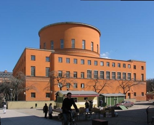
Vasastan, Stockholm
Vasastan, or formally Vasastaden, (Swedish for "Vasa town") is a 3.00 km2 large city district in central Stockholm, Sweden, being a part of Norrmalm borough.
The major parks in Vasastaden are Vasaparken and Observatorielunden near the centre and Vanadislunden and Bellevueparken in the north.
Vasastaden is considered Sweden’s most expensive district based on average price per square meter, a position the district has held since the 2010s.
The city district, most likely named after the street Vasagatan, in its turn named after King Gustav Vasa in 1885, was still a peripheral part of the city in the early 1880s. Before the end of that decade, however, some 150 buildings had been built and only the properties along Odengatan remained vacant. The expansion was preceded by a city plan established in 1879, a slightly more modest edition of the 1866 intentions of city planner Albert Lindhagen, in its turn largely a continuation north of an original 17th-century plan. Like the Baroque plan, the new plan took little or no account of local topographic variations, and where the two failed to reconcile, sites were simply set aside as parks or for major structures such as the Sabbatsberg Hospital.
Compared to central Stockholm, streets were widened to 18 metres, except for the main east-west-bound street Odengatan which was made 30 metres wide and adorned with plantings after continental prototypes. In accordance with construction charters from the 1870s, building corners where filleted and building heights adopted to street width and limited to five floors — embellishing proportions intended to bring light and air into the urban space. The Neo-Renaissance plaster architecture of the middle class residential buildings in southern Vasastaden is highly reminiscent of the Ringstraße in Vienna; the ground floors are dominated by horizontal elements with columns and pilasters above, while accentuated cornices closes the vertical compositions. Later architects failed to appreciate these Neo-Renaissance buildings and freed many of them of most of their decorations.
The north-eastern part of the district is called Sibirien (Siberia in English). The area borders Östermalm but has historically been a stronghold for the working class.
The origin of the name Sibirien (Eng. Siberia) originates from a time when the area was inhabited by the poor, who could not afford heating. People started to say that the area was "as cold and as far away as Siberia", hence the nickname.
In the north-western corner of the district are eight blocks forming Birkastaden, named after the 9th century settlement Birka, sometimes called Rörstrandsområdet (the "Rörstrand Area") which forms the compact northern frontier of Stockholm's historical city centre. As described above, Lindhagen's original intentions for the elevated area was to keep it as a park featuring the 17th century avenue of Karlberg Palace. In the city plan of 1879, however, the area was divided into two large blocks, which were split up into smaller properties in 1886, on a request from the local landowner, porcelain factory Rörstrand. This resulted in a new city plan which was adopted to local topographic variations and therefore features non-perpendicular street crossings.
Hub AI
Vasastan, Stockholm AI simulator
(@Vasastan, Stockholm_simulator)
Vasastan, Stockholm
Vasastan, or formally Vasastaden, (Swedish for "Vasa town") is a 3.00 km2 large city district in central Stockholm, Sweden, being a part of Norrmalm borough.
The major parks in Vasastaden are Vasaparken and Observatorielunden near the centre and Vanadislunden and Bellevueparken in the north.
Vasastaden is considered Sweden’s most expensive district based on average price per square meter, a position the district has held since the 2010s.
The city district, most likely named after the street Vasagatan, in its turn named after King Gustav Vasa in 1885, was still a peripheral part of the city in the early 1880s. Before the end of that decade, however, some 150 buildings had been built and only the properties along Odengatan remained vacant. The expansion was preceded by a city plan established in 1879, a slightly more modest edition of the 1866 intentions of city planner Albert Lindhagen, in its turn largely a continuation north of an original 17th-century plan. Like the Baroque plan, the new plan took little or no account of local topographic variations, and where the two failed to reconcile, sites were simply set aside as parks or for major structures such as the Sabbatsberg Hospital.
Compared to central Stockholm, streets were widened to 18 metres, except for the main east-west-bound street Odengatan which was made 30 metres wide and adorned with plantings after continental prototypes. In accordance with construction charters from the 1870s, building corners where filleted and building heights adopted to street width and limited to five floors — embellishing proportions intended to bring light and air into the urban space. The Neo-Renaissance plaster architecture of the middle class residential buildings in southern Vasastaden is highly reminiscent of the Ringstraße in Vienna; the ground floors are dominated by horizontal elements with columns and pilasters above, while accentuated cornices closes the vertical compositions. Later architects failed to appreciate these Neo-Renaissance buildings and freed many of them of most of their decorations.
The north-eastern part of the district is called Sibirien (Siberia in English). The area borders Östermalm but has historically been a stronghold for the working class.
The origin of the name Sibirien (Eng. Siberia) originates from a time when the area was inhabited by the poor, who could not afford heating. People started to say that the area was "as cold and as far away as Siberia", hence the nickname.
In the north-western corner of the district are eight blocks forming Birkastaden, named after the 9th century settlement Birka, sometimes called Rörstrandsområdet (the "Rörstrand Area") which forms the compact northern frontier of Stockholm's historical city centre. As described above, Lindhagen's original intentions for the elevated area was to keep it as a park featuring the 17th century avenue of Karlberg Palace. In the city plan of 1879, however, the area was divided into two large blocks, which were split up into smaller properties in 1886, on a request from the local landowner, porcelain factory Rörstrand. This resulted in a new city plan which was adopted to local topographic variations and therefore features non-perpendicular street crossings.