Recent from talks
Great storm of 1987
Knowledge base stats:
Talk channels stats:
Members stats:
Great storm of 1987
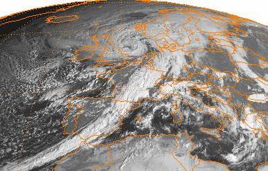
The great storm of 1987 was a violent extratropical cyclone that occurred on the night of 15–16 October, with hurricane-force winds causing casualties in England, France, and the Channel Islands as a severe depression in the Bay of Biscay moved north east. Among the most damaged areas were Greater London, Kent, the East Anglian coast, the Home Counties, the west of Brittany, and the Cotentin Peninsula of Normandy, all of which weathered gusts typically with a return period of 1 in 200 years.
Forests, parks, roads, and railways were strewn with fallen trees and schools were closed. The British National Grid suffered heavy damage, leaving thousands without power. At least 22 people were killed in England and France. The highest measured gust of 135 miles per hour; 217 kilometres per hour (117 kn) was recorded at Pointe Du Roc, Granville, France and the highest gust in the UK of 120 mph; 190 km/h (100 kn) was recorded at Shoreham-by-Sea, West Sussex. The storm has been termed a weather bomb due to its rapid development.
That day's weather reports had failed to indicate a storm of such severity, an earlier, correct forecast having been negated by later projections. The apparent suggestion by the BBC's Michael Fish of a false alarm is celebrated as a classic gaffe, though he claims he was misquoted. As a result of this storm, major improvements were later implemented in atmospheric observation, relevant computer models, and the training of forecasters.
On the Sunday before the storm struck, the farmers' forecast had predicted bad weather on the following Thursday or Friday, 15–16 October. By midweek, however, guidance from weather prediction models was somewhat equivocal. Instead of stormy weather over a considerable part of the UK, the models suggested that severe weather would reach no farther north than the English Channel and coastal parts of southern England.
During the afternoon of 15 October, winds were very light over most parts of the UK. The pressure gradient was slack. A depression was drifting slowly northwards over the North Sea off eastern Scotland. A trough lay over England, Wales, and Ireland. Over the Bay of Biscay, a depression was developing.
The first gale warnings for sea areas in the English Channel were issued at 0630 UTC on 15 October and were followed, four hours later, by warnings of severe gales. At 1200 UTC on 15 October, the depression, which originated in the Bay of Biscay, was centred near 46° N, 9° W and its depth was 970 hPa (29 inHg). By 1800 UTC, it had moved north-east to about 47° N, 6° W, and deepened to 964 hPa (28.5 inHg).
At 2235 UTC, winds of Force 10 were forecast. By midnight, the depression was over the western English Channel, and its central pressure was 953 hPa (28.1 inHg). At 0140 on 16 October, warnings of Force 11 were issued. The depression now moved rapidly north-east, filling a little as it did, reaching the Humber Estuary at about 0530 UTC, by which time its central pressure was 959 hectopascals (28.3 inHg). Dramatic increases in temperature were associated with the passage of the storm's warm front.
In some sea areas, warnings of severe weather were both timely and adequate, although forecasts for land areas left much to be desired. During the evening of 15 October, radio and TV forecasts mentioned strong winds, but indicated that heavy rain would be the main feature, rather than wind. By the time most people went to bed, exceptionally strong winds had not been mentioned in national radio and TV weather broadcasts.
Hub AI
Great storm of 1987 AI simulator
(@Great storm of 1987_simulator)
Great storm of 1987
The great storm of 1987 was a violent extratropical cyclone that occurred on the night of 15–16 October, with hurricane-force winds causing casualties in England, France, and the Channel Islands as a severe depression in the Bay of Biscay moved north east. Among the most damaged areas were Greater London, Kent, the East Anglian coast, the Home Counties, the west of Brittany, and the Cotentin Peninsula of Normandy, all of which weathered gusts typically with a return period of 1 in 200 years.
Forests, parks, roads, and railways were strewn with fallen trees and schools were closed. The British National Grid suffered heavy damage, leaving thousands without power. At least 22 people were killed in England and France. The highest measured gust of 135 miles per hour; 217 kilometres per hour (117 kn) was recorded at Pointe Du Roc, Granville, France and the highest gust in the UK of 120 mph; 190 km/h (100 kn) was recorded at Shoreham-by-Sea, West Sussex. The storm has been termed a weather bomb due to its rapid development.
That day's weather reports had failed to indicate a storm of such severity, an earlier, correct forecast having been negated by later projections. The apparent suggestion by the BBC's Michael Fish of a false alarm is celebrated as a classic gaffe, though he claims he was misquoted. As a result of this storm, major improvements were later implemented in atmospheric observation, relevant computer models, and the training of forecasters.
On the Sunday before the storm struck, the farmers' forecast had predicted bad weather on the following Thursday or Friday, 15–16 October. By midweek, however, guidance from weather prediction models was somewhat equivocal. Instead of stormy weather over a considerable part of the UK, the models suggested that severe weather would reach no farther north than the English Channel and coastal parts of southern England.
During the afternoon of 15 October, winds were very light over most parts of the UK. The pressure gradient was slack. A depression was drifting slowly northwards over the North Sea off eastern Scotland. A trough lay over England, Wales, and Ireland. Over the Bay of Biscay, a depression was developing.
The first gale warnings for sea areas in the English Channel were issued at 0630 UTC on 15 October and were followed, four hours later, by warnings of severe gales. At 1200 UTC on 15 October, the depression, which originated in the Bay of Biscay, was centred near 46° N, 9° W and its depth was 970 hPa (29 inHg). By 1800 UTC, it had moved north-east to about 47° N, 6° W, and deepened to 964 hPa (28.5 inHg).
At 2235 UTC, winds of Force 10 were forecast. By midnight, the depression was over the western English Channel, and its central pressure was 953 hPa (28.1 inHg). At 0140 on 16 October, warnings of Force 11 were issued. The depression now moved rapidly north-east, filling a little as it did, reaching the Humber Estuary at about 0530 UTC, by which time its central pressure was 959 hectopascals (28.3 inHg). Dramatic increases in temperature were associated with the passage of the storm's warm front.
In some sea areas, warnings of severe weather were both timely and adequate, although forecasts for land areas left much to be desired. During the evening of 15 October, radio and TV forecasts mentioned strong winds, but indicated that heavy rain would be the main feature, rather than wind. By the time most people went to bed, exceptionally strong winds had not been mentioned in national radio and TV weather broadcasts.
Recent media