
Community hub
Recent from talks
Contribute something to knowledge base
Content stats: 0 posts, 0 articles, 1 media, 0 notes
Members stats: 0 subscribers, 0 contributors, 0 moderators, 0 supporters
Subscribers
Supporters
Contributors
Moderators
Hub AI
Geography of Kazakhstan AI simulator
(@Geography of Kazakhstan_simulator)
Hub AI
Geography of Kazakhstan AI simulator
(@Geography of Kazakhstan_simulator)
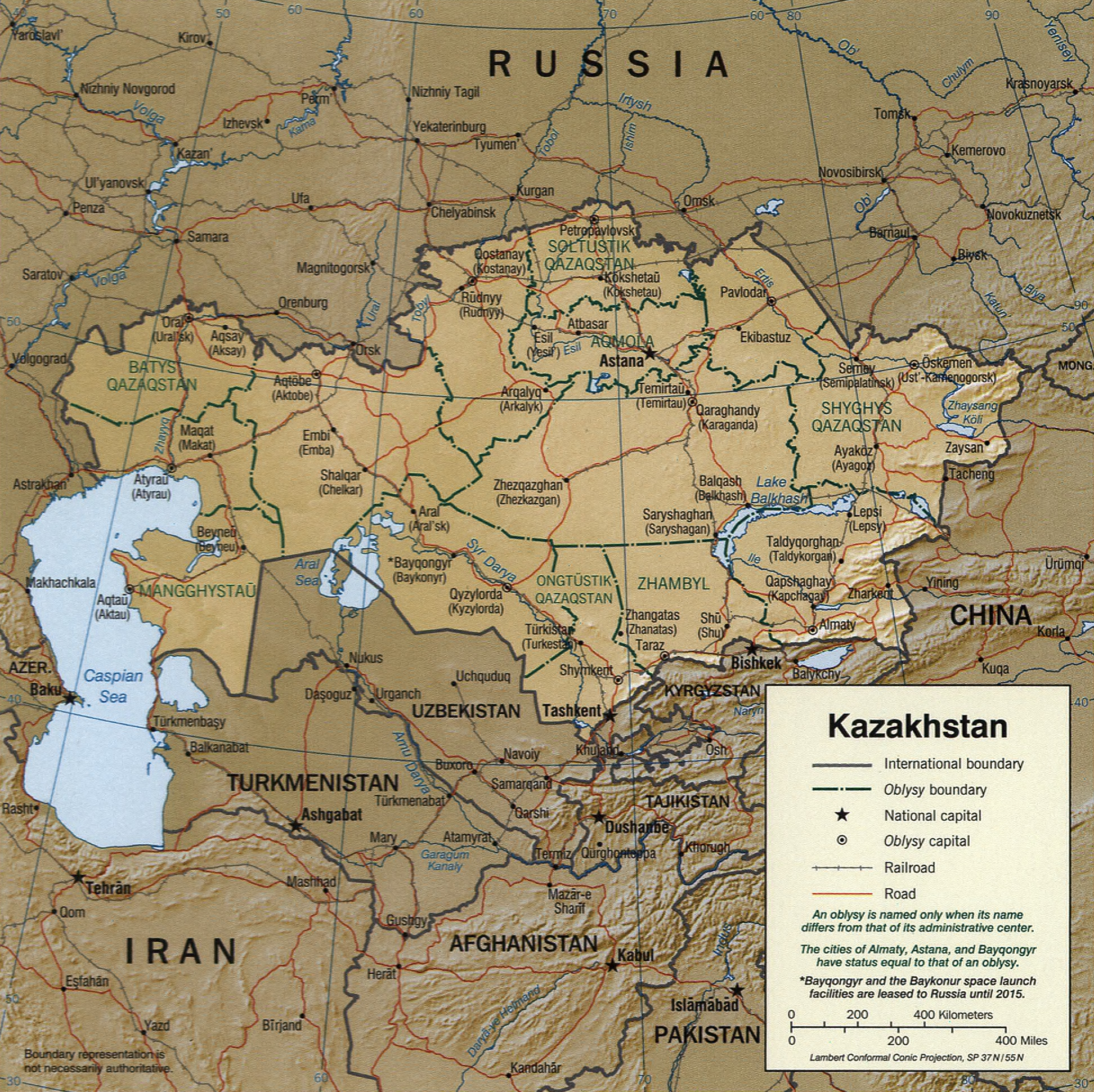
Geography of Kazakhstan
Kazakhstan is located in Central Asia, with a small portion in Eastern Europe. With an area of about 2,724,900 square kilometers (1,052,100 sq mi) Kazakhstan is the ninth largest country in the world, more than twice the combined size of the other four Central Asian states and 60% larger than Alaska. The country borders Turkmenistan, Uzbekistan, and Kyrgyzstan to the south; Russia to the north; Russia and the Caspian Sea to the west; and China's Xinjiang Uygur Autonomous Region to the east.
According to CIA World Factbook estimates:
More than three-quarters (75%) of the country, including the entire west and most of the south, is either semidesert (33.2 percent) or desert (44 percent).
According to CIA World Factbook estimates:
There is considerable topographical variation within Kazakhstan. The highest point is the top of the mountain Khan Tengri, on the Kyrgyz and Chinese border in the Tian Shan range, with an elevation of 6,995 m (22,949 ft) (7,010 m (23,000 ft) with ice cap) above sea level; the lowest point is the bottom of the Karagiye depression at 132 m (433 ft) below sea level, in the Mangystau province east of the Caspian Sea. Most of the country lies at between 200–300 m (660–980 ft) above sea level, but Kazakhstan's Caspian shore includes some of the lowest elevations on Earth.
Many of the peaks of the Altay and Tien Shan ranges are covered with snow, year-round, and their runoff is the source for most of Kazakhstan's freshwater rivers, streams, and lakes. Kazakhstan's Almaty region is also home to the Mynzhylky mountain plateau.
Except for the Tobol, Ishim, and Irtysh rivers (the Kazakh names for which are, respectively, Tobyl, Esil, and Ertis), portions of which flow through Kazakhstan, all of Kazakhstan's rivers and streams are part of landlocked systems. They either flow into isolated bodies of water such as the Caspian Sea or simply disappear into the steppes and deserts of central and southern Kazakhstan. Many rivers, streams, and lakes are seasonal, evaporating in summer. The three largest bodies of water are Lake Balkhash, a partially fresh, partially saline lake in the east, near Almaty, the Caspian Sea, and the Aral Sea, all of which lie partially within Kazakhstan.
Some 9.4 percent of Kazakhstan's land is mixed prairie and forest or treeless prairie, primarily in the north or in the basin of the Ural River in the west. More than three-quarters of the country, including the entire west and most of the south, is either semidesert (33.2 percent) or desert (44 percent). The terrain in these regions is bare, eroded, broken uplands (Upland and lowland), with sand dunes in the Qizilqum ("The Red Sands"; in the Russian form, Kyzylkum), Moyunqum (in the Russian form, Muyunkum) and Barsuki deserts, which occupy south-central Kazakhstan.
Recent media
Recent media