
Community hub
0 subscribers8 pages, 0 posts
Recent from talks
All channels
Be the first to start a discussion here.
Be the first to start a discussion here.
Be the first to start a discussion here.
Be the first to start a discussion here.
Contribute something
Welcome to the community hub built to collect knowledge and have discussions related to Districts of Vantaa.
Nothing was collected or created yet.
Districts of Vantaa
View on Wikipediafrom Wikipedia

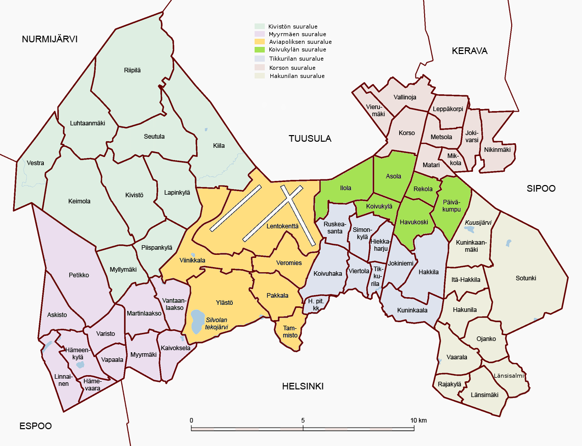
The city of Vantaa, Finland, incorporated in 1972 is divided into 60 districts. Key attractions in the city are the Church of St. Lauri (1492), the Parish of Helsinki Museum, and the Finnish Aviation Museum. Vantaa is connected with Helsinki and Lahti by motorways and railways. Helsinki-Vantaa airport is located in Vantaa. The city is also an important manufacturing centre. These districts are grouped among seven major regions.
List of districts
[edit]This is a list of the 60 districts of Vantaa, grouped among their respective major regions and ordered alphabetically.[1]
Aviapolis area
[edit]- Lentokenttä (Swedish: Flygfältet)
- Pakkala (Swedish: Backas)
- Tammisto (Swedish: Rosendal)
- Veromies (Swedish: Skattmans)
- Viinikkala (Swedish: Vinikby)
- Ylästö (Swedish: Övitsböle)
Hakunila (Håkansböle) area
[edit]- Hakunila (Swedish: Håkansböle)
- Itä-Hakkila (Swedish: Östra-Haxböle)
- Kuninkaanmäki (Swedish: Kungsbacka)
- Länsimäki (Swedish: Västerkulla)
- Länsisalmi (Swedish: Västersundom)
- Ojanko (Swedish: Gjutan)
- Rajakylä (Swedish: Råby)
- Sotunki (Swedish: Sottungsby)
- Vaarala (Swedish: Fagersta)
Kivistö area
[edit]- Keimola (Swedish: Käinby)
- Kiila (Swedish: Kila)
- Kivistö
- Lapinkylä (Swedish: Lappböle)
- Luhtaanmäki (Swedish: Luhtabacka)
- Myllymäki (Swedish: Kvarnbacka)
- Piispankylä (Swedish: Biskopsböle)
- Riipilä (Swedish: Ripuby)
- Seutula (Swedish: Sjöskog)
- Vestra (Swedish: Västra)
Koivukylä (Björkby) area
[edit]- Asola
- Havukoski
- Ilola (Swedish: Gladas)
- Koivukylä (Swedish: Björkby)
- Päiväkumpu (Swedish: Lövkulla)
- Rekola (Vantaa) (Swedish: Räckhals)
Korso area
[edit]- Jokivarsi
- Korso
- Leppäkorpi (Swedish: Alkärr)
- Matari (Swedish: Matar)
- Metsola (Swedish: Skogsbrinken)
- Mikkola
- Nikinmäki (Swedish: Nissbacka)
- Vallinoja (Swedish: Fallbäcken)
- Vierumäki
Myyrmäki (Myrbacka) area
[edit]- Askisto (Swedish: Askis)
- Hämeenkylä (Swedish: Tavastby)
- Hämevaara (Swedish: Tavasteberga)
- Kaivoksela (Swedish: Gruvsta)
- Linnainen (Swedish: Linnais)
- Martinlaakso (Swedish: Mårtensdal)
- Myyrmäki (Swedish: Myrbacka)
- Petikko
- Vantaanlaakso (Swedish: Vandadalen)
- Vapaala (Swedish: Friherrs)
- Varisto (Swedish: Varistorna)
Tikkurila (Dickursby) area
[edit]- Hakkila (Swedish: Haxböle)
- Helsingin pitäjän kirkonkylä (Swedish: Helsinge kyrkoby)
- Hiekkaharju (Swedish: Sandkulla)
- Jokiniemi (Swedish: Ånas)
- Koivuhaka (Swedish: Björkhagen)
- Kuninkaala (Swedish: Fastböle)
- Ruskeasanta (Swedish: Rödsand)
- Simonkylä (Swedish: Simonsböle)
- Tikkurila (Swedish: Dickursby)
- Viertola (Swedish: Bäckby)
References
[edit]- ^ "Archived copy" (PDF). Archived from the original (PDF) on 2013-06-19. Retrieved 2015-02-02.
{{cite web}}: CS1 maint: archived copy as title (link)