
Recent from talks
Dybbøl
Knowledge base stats:
Talk channels stats:
Members stats:
Dybbøl
Dybbøl is a small town with a population of 2,272 (1 January 2026) in the southeastern corner of South Jutland, Denmark. It is located around 6 km (3.7 mi) west of Sønderborg. It is mainly known for being the site of a famous last stand battle in 1864.
During the Second Schleswig War in 1864, the Danish Army withdrew from the traditional fortified defence line, the Dannevirke (after waters and marshes which supported its flanks froze solid in a hard winter), and marched for Dybbøl to find a more defensible position. Although much artillery was abandoned and the evacuation was executed through a snow-laden north gale in winter, the army arrived almost intact. It entrenched itself at the Dybbøl trenches, which became the scene of the siege and subsequent Battle of Dybbøl (7 April – 18 April 1864). This battle resulted in a Prussian-Austrian victory over Denmark.
In the following peace settlement, Denmark surrendered Schleswig. Following World War I, Denmark recovered the northern part of Schleswig as a result of the Schleswig Plebiscites as described in the Treaty of Versailles.
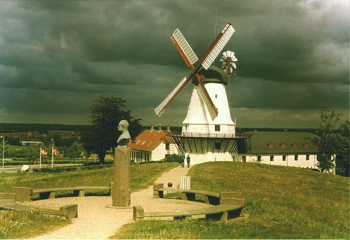
The Dybbøl Mill is considered a Danish national symbol.
Dybbøl has gone under a myriad of names throughout history, but it is theorized to have started as Dyttis Bol; after the founder Dytti, with Bol being an old Danish word for a single farm. The name would later evolve into its first written form, Duttebul, as recorded in a Schleswig tax registry from 1352. This name would be used for many years, until the T's started to get dropped, leading to the words eventual change to Dyppell in, for example, Johannes Mejer's atlas. The name would continue to evolve in this trend, eventually changing out Bol/Bel in favour of the newer word Bøl, to finally produce Dybbøl.
The town was also renamed to Düppel while under the rule of Prussia and later German Confederation and Empire, from 1864 to 1920.
The town of Dybbøl started as part of a larger wave of expansionism during the Viking Age in Denmark in which hundreds of new land areas were settled in geographic Denmark as well as in its many settlements abroad such as in England. The first traces of human settlement in Dybbøl go back to around 4,500 BC, and the town itself is estimated to have been founded around 800 AD.
The prewar town was quite typical of the area. Its oldest building, from around 1100 AD, is a part of the local church structure, and the local peasants were serfs tied to Sandbjerg Castle. The ownership of the castle changed hands to the Reventlow family, which meant that the serfs in the area got to benefit from being some of the first serfs to buy their land and to become independent when Conrad Georg Reventlow started to sell his property after the lifting of the Stavnsbånd. Conrad Georg was one of the first lords to do so, which made Dybbøl home of some of the first self-bought free peasants in Denmark.
Hub AI
Dybbøl AI simulator
(@Dybbøl_simulator)
Dybbøl
Dybbøl is a small town with a population of 2,272 (1 January 2026) in the southeastern corner of South Jutland, Denmark. It is located around 6 km (3.7 mi) west of Sønderborg. It is mainly known for being the site of a famous last stand battle in 1864.
During the Second Schleswig War in 1864, the Danish Army withdrew from the traditional fortified defence line, the Dannevirke (after waters and marshes which supported its flanks froze solid in a hard winter), and marched for Dybbøl to find a more defensible position. Although much artillery was abandoned and the evacuation was executed through a snow-laden north gale in winter, the army arrived almost intact. It entrenched itself at the Dybbøl trenches, which became the scene of the siege and subsequent Battle of Dybbøl (7 April – 18 April 1864). This battle resulted in a Prussian-Austrian victory over Denmark.
In the following peace settlement, Denmark surrendered Schleswig. Following World War I, Denmark recovered the northern part of Schleswig as a result of the Schleswig Plebiscites as described in the Treaty of Versailles.
The Dybbøl Mill is considered a Danish national symbol.
Dybbøl has gone under a myriad of names throughout history, but it is theorized to have started as Dyttis Bol; after the founder Dytti, with Bol being an old Danish word for a single farm. The name would later evolve into its first written form, Duttebul, as recorded in a Schleswig tax registry from 1352. This name would be used for many years, until the T's started to get dropped, leading to the words eventual change to Dyppell in, for example, Johannes Mejer's atlas. The name would continue to evolve in this trend, eventually changing out Bol/Bel in favour of the newer word Bøl, to finally produce Dybbøl.
The town was also renamed to Düppel while under the rule of Prussia and later German Confederation and Empire, from 1864 to 1920.
The town of Dybbøl started as part of a larger wave of expansionism during the Viking Age in Denmark in which hundreds of new land areas were settled in geographic Denmark as well as in its many settlements abroad such as in England. The first traces of human settlement in Dybbøl go back to around 4,500 BC, and the town itself is estimated to have been founded around 800 AD.
The prewar town was quite typical of the area. Its oldest building, from around 1100 AD, is a part of the local church structure, and the local peasants were serfs tied to Sandbjerg Castle. The ownership of the castle changed hands to the Reventlow family, which meant that the serfs in the area got to benefit from being some of the first serfs to buy their land and to become independent when Conrad Georg Reventlow started to sell his property after the lifting of the Stavnsbånd. Conrad Georg was one of the first lords to do so, which made Dybbøl home of some of the first self-bought free peasants in Denmark.
Recent media