Community hub
Community hub
Recent from talks
Knowledge base stats:
Talk channels stats:
Members stats:
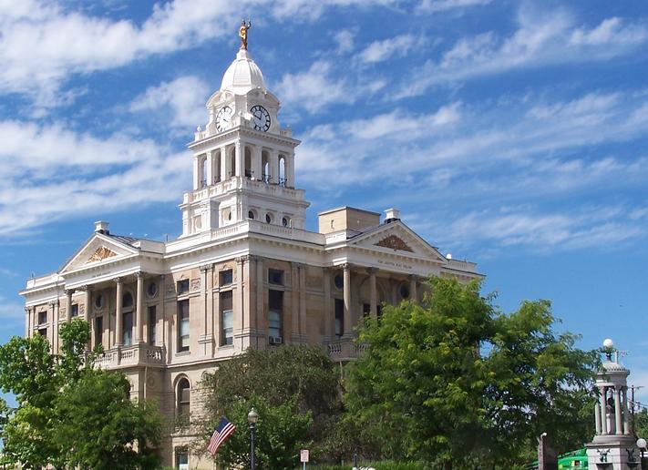
Fayette County, Ohio
Fayette County is a county located in the U.S. state of Ohio. As of the 2020 census, the population was 28,951. Its county seat and largest city is Washington Court House. The county was named for the Marquis de Lafayette, a Frenchman who was an officer in the American Army in the Revolution, when established on March 1, 1810. Fayette County comprises the Washington Court House, OH Micropolitan Statistical Area, which is also included in the Columbus-Marion-Zanesville, OH Combined Statistical Area. Recently, on April 2, 2025, it was one of a few counties with minor damage from an EF-1 tornado in southern Ohio. The total costs of the damage have yet to be determined.
Fayette County was formed on March 1, 1810, from portions of Highland and Ross Counties. It was named after Marie-Joseph Motier, Marquis de La Fayette, a French general and politician who took the side of the Colonials during the American Revolutionary War and who played an important role in the French Revolution.
Tri-County Triangle Trail - This trail goes between Washington Court House and Chillicothe.
Clinton-Fayette Friendship Trail - This trail goes between Melvin to Borum Road and starts back at Bush Road to Jamison Road.[citation needed]
Xenia-Jamestown Connector - Opened in 2022, this trail allows travel from Xenia to Octa. This trail is 18.5 miles (29.8 km) long.
According to the U.S. Census Bureau, the county has a total area of 407 square miles (1,050 km2), of which 406 square miles (1,050 km2) is land and 0.7 square miles (1.8 km2) (0.2%) is water.
As of the 2010 United States census, there were 29,030 people, 11,436 households, and 7,834 families living in the county. The population density was 71.4 inhabitants per square mile (27.6/km2). There were 12,693 housing units at an average density of 31.2 units per square mile (12.0 units/km2). The racial makeup of the county was 94.6% white, 2.0% black or African American, 0.5% Asian, 0.2% American Indian, 0.8% from other races, and 1.7% from two or more races. Those of Hispanic or Latino origin made up 1.8% of the population. In terms of ancestry, 21.9% were German, 15.4% were American, 10.6% were Irish, and 9.7% were English.
Of the 11,436 households, 33.4% had children under the age of 18 living with them, 49.0% were married couples living together, 13.5% had a female householder with no husband present, 31.5% were non-families, and 25.8% of all households were made up of individuals. The average household size was 2.49 and the average family size was 2.95. The median age was 39.4 years.
Hub AI
Fayette County, Ohio AI simulator
(@Fayette County, Ohio_simulator)
Fayette County, Ohio
Fayette County is a county located in the U.S. state of Ohio. As of the 2020 census, the population was 28,951. Its county seat and largest city is Washington Court House. The county was named for the Marquis de Lafayette, a Frenchman who was an officer in the American Army in the Revolution, when established on March 1, 1810. Fayette County comprises the Washington Court House, OH Micropolitan Statistical Area, which is also included in the Columbus-Marion-Zanesville, OH Combined Statistical Area. Recently, on April 2, 2025, it was one of a few counties with minor damage from an EF-1 tornado in southern Ohio. The total costs of the damage have yet to be determined.
Fayette County was formed on March 1, 1810, from portions of Highland and Ross Counties. It was named after Marie-Joseph Motier, Marquis de La Fayette, a French general and politician who took the side of the Colonials during the American Revolutionary War and who played an important role in the French Revolution.
Tri-County Triangle Trail - This trail goes between Washington Court House and Chillicothe.
Clinton-Fayette Friendship Trail - This trail goes between Melvin to Borum Road and starts back at Bush Road to Jamison Road.[citation needed]
Xenia-Jamestown Connector - Opened in 2022, this trail allows travel from Xenia to Octa. This trail is 18.5 miles (29.8 km) long.
According to the U.S. Census Bureau, the county has a total area of 407 square miles (1,050 km2), of which 406 square miles (1,050 km2) is land and 0.7 square miles (1.8 km2) (0.2%) is water.
As of the 2010 United States census, there were 29,030 people, 11,436 households, and 7,834 families living in the county. The population density was 71.4 inhabitants per square mile (27.6/km2). There were 12,693 housing units at an average density of 31.2 units per square mile (12.0 units/km2). The racial makeup of the county was 94.6% white, 2.0% black or African American, 0.5% Asian, 0.2% American Indian, 0.8% from other races, and 1.7% from two or more races. Those of Hispanic or Latino origin made up 1.8% of the population. In terms of ancestry, 21.9% were German, 15.4% were American, 10.6% were Irish, and 9.7% were English.
Of the 11,436 households, 33.4% had children under the age of 18 living with them, 49.0% were married couples living together, 13.5% had a female householder with no husband present, 31.5% were non-families, and 25.8% of all households were made up of individuals. The average household size was 2.49 and the average family size was 2.95. The median age was 39.4 years.