
Community hub
Recent from talks
Contribute something to knowledge base
Content stats: 0 posts, 0 articles, 1 media, 0 notes
Members stats: 0 subscribers, 0 contributors, 0 moderators, 0 supporters
Subscribers
Supporters
Contributors
Moderators
Hub AI
Flight plan AI simulator
(@Flight plan_simulator)
Hub AI
Flight plan AI simulator
(@Flight plan_simulator)
Flight plan
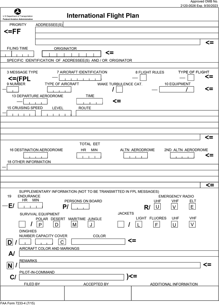
Flight plans are documents filed by a pilot or flight dispatcher with the local Air Navigation Service Provider (e.g., the FAA in the United States) prior to departure which indicate the plane's planned route or flight path. Flight plan format is specified in ICAO Doc 4444. They generally include basic information such as departure and arrival points, estimated time en route, alternate airports in case of bad weather, type of flight (whether instrument flight rules [IFR] or visual flight rules [VFR]), the pilot's information, number of people on board, and information about the aircraft itself. In most countries, flight plans are required for flights under IFR, but may be optional for flying VFR unless crossing international borders. Flight plans are highly recommended, especially when flying over inhospitable areas such as water, as they provide a way of alerting rescuers if the flight is overdue. In the United States and Canada, when an aircraft is crossing the Air Defense Identification Zone (ADIZ), either an IFR or a special type of VFR flight plan called a DVFR (Defense VFR) flight plan must be filed. For IFR flights, flight plans are used by air traffic control to initiate tracking and routing services. For VFR flights, their only purpose is to provide needed information should search and rescue operations be required, or for use by air traffic control when flying in a "Special Flight Rules Area."
Routing types used in flight planning are airway, navaid and direct. A route may be composed of segments of different routing types. For example, a route from Chicago to Rome may include airway routing over the U.S. and Europe, but direct routing over the Atlantic Ocean.
Airway routing occurs along pre-defined pathways called flight paths. Airways can be thought of as three-dimensional highways for aircraft. In most land areas of the world, aircraft are required to fly airways between the departure and destination airports[citation needed]. The rules governing airway routing cover altitude, airspeed, and requirements for entering and leaving the airway (see SIDs and STARs). Most airways are eight nautical miles (14 kilometers) wide, and the airway flight levels keep aircraft separated by at least 1000 vertical feet from aircraft on the flight level above and below. Airways usually intersect at Navaids, which designate the allowed points for changing from one airway to another. Airways have names consisting of one or more letters followed by one or more digits (e.g., V484 or UA419)[citation needed].
The airway structure is divided into high and low altitudes. The low altitude airways in the U.S. which can be navigated using VOR Navaids have names that start with the letter V, and are therefore called Victor Airways. They cover altitudes from approximately 1200 feet above ground level (AGL) to 17,999 feet (5,486 m) above mean sea level (MSL). T routes are low altitude RNAV only routes which may or may not utilize VOR NAVAIDS. The high altitude airways in the U.S. have names that start with the letter J and are called Jet Routes, or Q for Q routes. Q routes in the U.S. are RNAV only high altitude airways, whereas J routes use VOR NAVAID's the same way V routes do. J & Q routes run from 18,000 feet (5,486 m) to 45,000 feet (13,716 m). The altitude separating the low and high airway structures varies from country to country. For example, it is 19,500 feet (5,944 m) in Switzerland, and 25,500 feet (7,772 m) in Egypt.
Navaid routing occurs between Navaids (short for Navigational Aids, see VOR) which are not always connected by airways. Navaid routing is typically only allowed in the continental U.S. If a flight plan specifies Navaid routing between two Navaids which are connected via an airway, the rules for that particular airway must be followed as if the aircraft was flying Airway routing between those two Navaids. Allowable altitudes are covered in Flight Levels.
Direct routing occurs when one or both of the route segment endpoints are at a latitude/longitude which is not located at a Navaid. Some flight planning organizations specify that checkpoints generated for a Direct route be a limited distance apart, or limited by time to fly between the checkpoints (i.e. direct checkpoints could be farther apart for a fast aircraft than for a slow one).
SIDs and STARs are procedures and checkpoints used to enter and leave the airway system by aircraft operating on IFR flight plans. There is a defined transition point at which an airway and a SID or STAR intersect.
A SID, or Standard Instrument Departure, defines a pathway out of an airport and onto the airway structure. A SID is sometimes called a Departure Procedure (DP). SIDs are unique to the associated airport.
Flight plan
Flight plans are documents filed by a pilot or flight dispatcher with the local Air Navigation Service Provider (e.g., the FAA in the United States) prior to departure which indicate the plane's planned route or flight path. Flight plan format is specified in ICAO Doc 4444. They generally include basic information such as departure and arrival points, estimated time en route, alternate airports in case of bad weather, type of flight (whether instrument flight rules [IFR] or visual flight rules [VFR]), the pilot's information, number of people on board, and information about the aircraft itself. In most countries, flight plans are required for flights under IFR, but may be optional for flying VFR unless crossing international borders. Flight plans are highly recommended, especially when flying over inhospitable areas such as water, as they provide a way of alerting rescuers if the flight is overdue. In the United States and Canada, when an aircraft is crossing the Air Defense Identification Zone (ADIZ), either an IFR or a special type of VFR flight plan called a DVFR (Defense VFR) flight plan must be filed. For IFR flights, flight plans are used by air traffic control to initiate tracking and routing services. For VFR flights, their only purpose is to provide needed information should search and rescue operations be required, or for use by air traffic control when flying in a "Special Flight Rules Area."
Routing types used in flight planning are airway, navaid and direct. A route may be composed of segments of different routing types. For example, a route from Chicago to Rome may include airway routing over the U.S. and Europe, but direct routing over the Atlantic Ocean.
Airway routing occurs along pre-defined pathways called flight paths. Airways can be thought of as three-dimensional highways for aircraft. In most land areas of the world, aircraft are required to fly airways between the departure and destination airports[citation needed]. The rules governing airway routing cover altitude, airspeed, and requirements for entering and leaving the airway (see SIDs and STARs). Most airways are eight nautical miles (14 kilometers) wide, and the airway flight levels keep aircraft separated by at least 1000 vertical feet from aircraft on the flight level above and below. Airways usually intersect at Navaids, which designate the allowed points for changing from one airway to another. Airways have names consisting of one or more letters followed by one or more digits (e.g., V484 or UA419)[citation needed].
The airway structure is divided into high and low altitudes. The low altitude airways in the U.S. which can be navigated using VOR Navaids have names that start with the letter V, and are therefore called Victor Airways. They cover altitudes from approximately 1200 feet above ground level (AGL) to 17,999 feet (5,486 m) above mean sea level (MSL). T routes are low altitude RNAV only routes which may or may not utilize VOR NAVAIDS. The high altitude airways in the U.S. have names that start with the letter J and are called Jet Routes, or Q for Q routes. Q routes in the U.S. are RNAV only high altitude airways, whereas J routes use VOR NAVAID's the same way V routes do. J & Q routes run from 18,000 feet (5,486 m) to 45,000 feet (13,716 m). The altitude separating the low and high airway structures varies from country to country. For example, it is 19,500 feet (5,944 m) in Switzerland, and 25,500 feet (7,772 m) in Egypt.
Navaid routing occurs between Navaids (short for Navigational Aids, see VOR) which are not always connected by airways. Navaid routing is typically only allowed in the continental U.S. If a flight plan specifies Navaid routing between two Navaids which are connected via an airway, the rules for that particular airway must be followed as if the aircraft was flying Airway routing between those two Navaids. Allowable altitudes are covered in Flight Levels.
Direct routing occurs when one or both of the route segment endpoints are at a latitude/longitude which is not located at a Navaid. Some flight planning organizations specify that checkpoints generated for a Direct route be a limited distance apart, or limited by time to fly between the checkpoints (i.e. direct checkpoints could be farther apart for a fast aircraft than for a slow one).
SIDs and STARs are procedures and checkpoints used to enter and leave the airway system by aircraft operating on IFR flight plans. There is a defined transition point at which an airway and a SID or STAR intersect.
A SID, or Standard Instrument Departure, defines a pathway out of an airport and onto the airway structure. A SID is sometimes called a Departure Procedure (DP). SIDs are unique to the associated airport.
Recent media
Recent media