The Frying Pan Shoals are a shifting area of shoals off Cape Fear in North Carolina, United States. Formed by silt from the Cape Fear River, the shoals are over 28 miles long and resemble a frying pan in shape.[1] They provide fishing.[2][3]
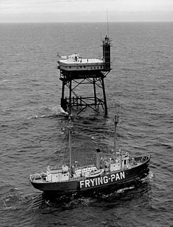
The shoals are known for the high number of shipwrecks found in the region and are deemed part of the Graveyard of the Atlantic.[4] From May 1994 to August 2008 over 130 new shipwreck locations were discovered in the area. Known since the beginning of European exploration, the shoals were marked on a map in 1738. The southern edge of the shoals has been marked by nine lightships including the Frying Pan, a light tower, and a weather buoy. The Bald Head Light and the Oak Island lighthouse have also provided warning to mariners.