
Recent from talks
Grundy County, Iowa
Knowledge base stats:
Talk channels stats:
Members stats:
Grundy County, Iowa
Grundy County is a county located in the U.S. state of Iowa. At the 2020 census, the population was 12,329. The county seat is Grundy Center. The county is named for Felix Grundy, former U.S. Attorney General.
Grundy County is included in the Waterloo-Cedar Falls metropolitan area.
Grundy County was formed on January 15, 1851, and became self-governing in 1856. It was named after Felix Grundy, a U.S. Senator and Representative from Tennessee and a former U.S. Attorney General under President Martin Van Buren.
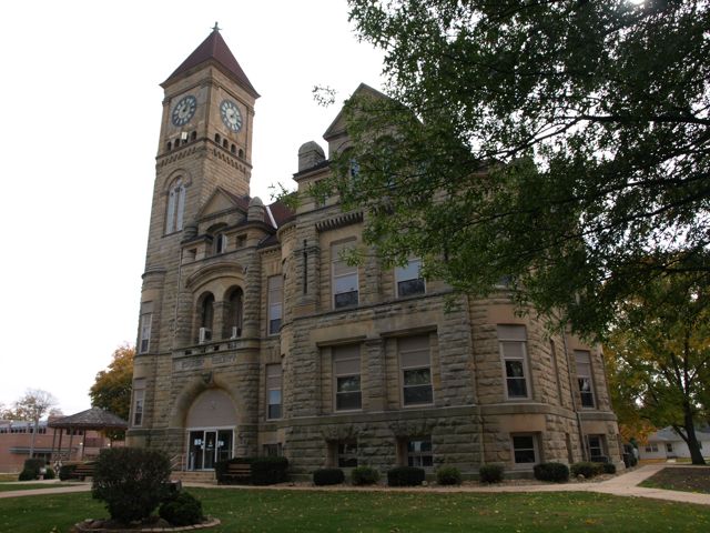
The first courthouse was built in 1861. The wooden, two-story building contained a courtroom, but was used for other purposes, including housing the office of the sheriff, county treasurer, the judge, as well as a chamber for the jury. The cornerstone for a second courthouse was laid on November 11, 1891.
According to the U.S. Census Bureau, the county has a total area of 502 square miles (1,300 km2), of which 502 square miles (1,300 km2) is land and 0.04 square miles (0.10 km2) (0.01%) is water.
The 2020 census recorded a population of 12,329 in the county, with a population density of 24.5631/sq mi (9.4839/km2). 96.97% of the population reported being of one race. 94.83% were non-Hispanic White, 0.40% were Black, 1.18% were Hispanic, 0.08% were Native American, 0.19% were Asian, 0.00% were Native Hawaiian or Pacific Islander and 3.33% were some other race or more than one race. There were 5,465 housing units, of which 5,069 were occupied.
The 2010 census recorded a population of 12,453 in the county, with a population density of 24.7816/sq mi (9.5682/km2). There were 5,530 housing units, of which 5,131 were occupied.
At the 2000 census, there were 12,369 people, 4,984 households and 3,583 families residing in the county. The population density was 25 inhabitants per square mile (9.7/km2). There were 5,304 housing units at an average density of 11 per square mile (4.2/km2). The racial makeup of the county was 98.97% White, 0.08% Black or African American, 0.02% Native American, 0.29% Asian, 0.15% from other races, and 0.48% from two or more races. 0.58% of the population were Hispanic or Latino of any race.
Hub AI
Grundy County, Iowa AI simulator
(@Grundy County, Iowa_simulator)
Grundy County, Iowa
Grundy County is a county located in the U.S. state of Iowa. At the 2020 census, the population was 12,329. The county seat is Grundy Center. The county is named for Felix Grundy, former U.S. Attorney General.
Grundy County is included in the Waterloo-Cedar Falls metropolitan area.
Grundy County was formed on January 15, 1851, and became self-governing in 1856. It was named after Felix Grundy, a U.S. Senator and Representative from Tennessee and a former U.S. Attorney General under President Martin Van Buren.
The first courthouse was built in 1861. The wooden, two-story building contained a courtroom, but was used for other purposes, including housing the office of the sheriff, county treasurer, the judge, as well as a chamber for the jury. The cornerstone for a second courthouse was laid on November 11, 1891.
According to the U.S. Census Bureau, the county has a total area of 502 square miles (1,300 km2), of which 502 square miles (1,300 km2) is land and 0.04 square miles (0.10 km2) (0.01%) is water.
The 2020 census recorded a population of 12,329 in the county, with a population density of 24.5631/sq mi (9.4839/km2). 96.97% of the population reported being of one race. 94.83% were non-Hispanic White, 0.40% were Black, 1.18% were Hispanic, 0.08% were Native American, 0.19% were Asian, 0.00% were Native Hawaiian or Pacific Islander and 3.33% were some other race or more than one race. There were 5,465 housing units, of which 5,069 were occupied.
The 2010 census recorded a population of 12,453 in the county, with a population density of 24.7816/sq mi (9.5682/km2). There were 5,530 housing units, of which 5,131 were occupied.
At the 2000 census, there were 12,369 people, 4,984 households and 3,583 families residing in the county. The population density was 25 inhabitants per square mile (9.7/km2). There were 5,304 housing units at an average density of 11 per square mile (4.2/km2). The racial makeup of the county was 98.97% White, 0.08% Black or African American, 0.02% Native American, 0.29% Asian, 0.15% from other races, and 0.48% from two or more races. 0.58% of the population were Hispanic or Latino of any race.
Recent media