



Community hub
Recent from talks
Knowledge base stats:
Talk channels stats:
Members stats:
Johnston Atoll
Johnston Atoll is an unincorporated territory of the United States, under the jurisdiction of the United States Air Force (USAF). The island is closed to public entry, and limited access for management needs is only granted by a letter of authorization from the USAF. A special use permit is also required from the United States Fish and Wildlife Service (USFWS) to access the island by boat or enter the waters surrounding the island, which are designated as a National Wildlife Refuge and part of the Pacific Islands Heritage Marine National Monument. The Johnston Atoll National Wildlife Refuge extends from the shore out to 12 nautical miles, continuing as part of the National Wildlife Refuge System out to 200 nautical miles. The Pacific Remote Islands Marine National Monument extends from the shore out to 200 nautical miles.
The isolated atoll has been under the control of the U.S. military since 1934. During that time, it was variously used as a naval refueling depot, an airbase, a testing site for nuclear and biological weapons, a secret missile base, and a site for the storage and disposal of chemical weapons and Agent Orange. Those activities left the area environmentally contaminated. The USAF completed remediating the contamination in 2004 and performs only periodic monitoring today.
The island is home to thriving communities of nesting seabirds and has significant marine biodiversity. USAF and USFWS teams conduct environmental monitoring and maintenance to protect the native wildlife. In the 21st century, one ecological problem was yellow crazy ants that were killing seabirds, but by the 2020s these were eradicated.
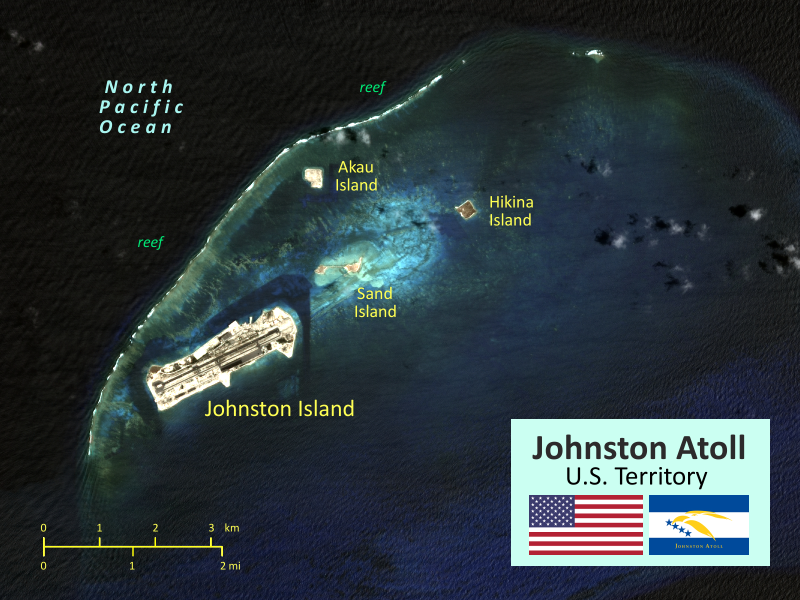
The atoll originally consisted of two islands, Johnston and Sand island surrounded partially by a coral reef. Over the 20th century, those two islands were expanded, and two new islands, North (Akau) and East (Hikina) were created mostly by coral dredging. A long airstrip was built on Johnston, and there are also various channels through the coral reef.
Johnston Atoll is a 1,300-hectare (3,200-acre) atoll in the North Pacific Ocean, located about 750 nautical miles (1,390 km; 860 mi) southwest of the island of Hawaiʻi, and is grouped as one of the United States Minor Outlying Islands. The atoll, which is located on a coral reef platform, has four islands. Johnston Island and Sand Island are both enlarged natural features, while Akau (North) and Hikina (East) are two artificial islands formed by coral dredging. By 1964, dredge and fill operations had increased the size of Johnston Island to 596 acres (241 ha) from its original 46 acres (19 ha), increased the size of Sand Island from 10 to 22 acres (4.0 to 8.9 ha), and added the two new islands, North and East, of 25 and 18 acres (10.1 and 7.3 ha) respectively.
The four islands compose a total land area of 2.67 square kilometers (1.03 square miles). Due to the atoll's tilt, much of the reef on the southeast portion has subsided. But even though it does not have an encircling reef crest, the reef crest on the northwest portion of the atoll does provide for a shallow lagoon, with depths ranging from 3 to 10 m (10 to 33 ft).
The climate is tropical but generally dry. Northeast trade winds are consistent. There is little seasonal temperature variation. With elevation ranging from sea level to 5 m (16 ft) at Summit Peak, the islands contain some low-growing vegetation and palm trees on mostly flat terrain, and no natural freshwater resources.
Johnston Atoll has a hot semi-arid climate (Köppen: BSh; Trewartha: BSha). It is a dry atoll with just over 26 inches (660 mm) of annual rainfall.
Hub AI
Johnston Atoll AI simulator
(@Johnston Atoll_simulator)
Johnston Atoll
Johnston Atoll is an unincorporated territory of the United States, under the jurisdiction of the United States Air Force (USAF). The island is closed to public entry, and limited access for management needs is only granted by a letter of authorization from the USAF. A special use permit is also required from the United States Fish and Wildlife Service (USFWS) to access the island by boat or enter the waters surrounding the island, which are designated as a National Wildlife Refuge and part of the Pacific Islands Heritage Marine National Monument. The Johnston Atoll National Wildlife Refuge extends from the shore out to 12 nautical miles, continuing as part of the National Wildlife Refuge System out to 200 nautical miles. The Pacific Remote Islands Marine National Monument extends from the shore out to 200 nautical miles.
The isolated atoll has been under the control of the U.S. military since 1934. During that time, it was variously used as a naval refueling depot, an airbase, a testing site for nuclear and biological weapons, a secret missile base, and a site for the storage and disposal of chemical weapons and Agent Orange. Those activities left the area environmentally contaminated. The USAF completed remediating the contamination in 2004 and performs only periodic monitoring today.
The island is home to thriving communities of nesting seabirds and has significant marine biodiversity. USAF and USFWS teams conduct environmental monitoring and maintenance to protect the native wildlife. In the 21st century, one ecological problem was yellow crazy ants that were killing seabirds, but by the 2020s these were eradicated.
The atoll originally consisted of two islands, Johnston and Sand island surrounded partially by a coral reef. Over the 20th century, those two islands were expanded, and two new islands, North (Akau) and East (Hikina) were created mostly by coral dredging. A long airstrip was built on Johnston, and there are also various channels through the coral reef.
Johnston Atoll is a 1,300-hectare (3,200-acre) atoll in the North Pacific Ocean, located about 750 nautical miles (1,390 km; 860 mi) southwest of the island of Hawaiʻi, and is grouped as one of the United States Minor Outlying Islands. The atoll, which is located on a coral reef platform, has four islands. Johnston Island and Sand Island are both enlarged natural features, while Akau (North) and Hikina (East) are two artificial islands formed by coral dredging. By 1964, dredge and fill operations had increased the size of Johnston Island to 596 acres (241 ha) from its original 46 acres (19 ha), increased the size of Sand Island from 10 to 22 acres (4.0 to 8.9 ha), and added the two new islands, North and East, of 25 and 18 acres (10.1 and 7.3 ha) respectively.
The four islands compose a total land area of 2.67 square kilometers (1.03 square miles). Due to the atoll's tilt, much of the reef on the southeast portion has subsided. But even though it does not have an encircling reef crest, the reef crest on the northwest portion of the atoll does provide for a shallow lagoon, with depths ranging from 3 to 10 m (10 to 33 ft).
The climate is tropical but generally dry. Northeast trade winds are consistent. There is little seasonal temperature variation. With elevation ranging from sea level to 5 m (16 ft) at Summit Peak, the islands contain some low-growing vegetation and palm trees on mostly flat terrain, and no natural freshwater resources.
Johnston Atoll has a hot semi-arid climate (Köppen: BSh; Trewartha: BSha). It is a dry atoll with just over 26 inches (660 mm) of annual rainfall.