Recent from talks
Kaimai Range
Knowledge base stats:
Talk channels stats:
Members stats:
Kaimai Range
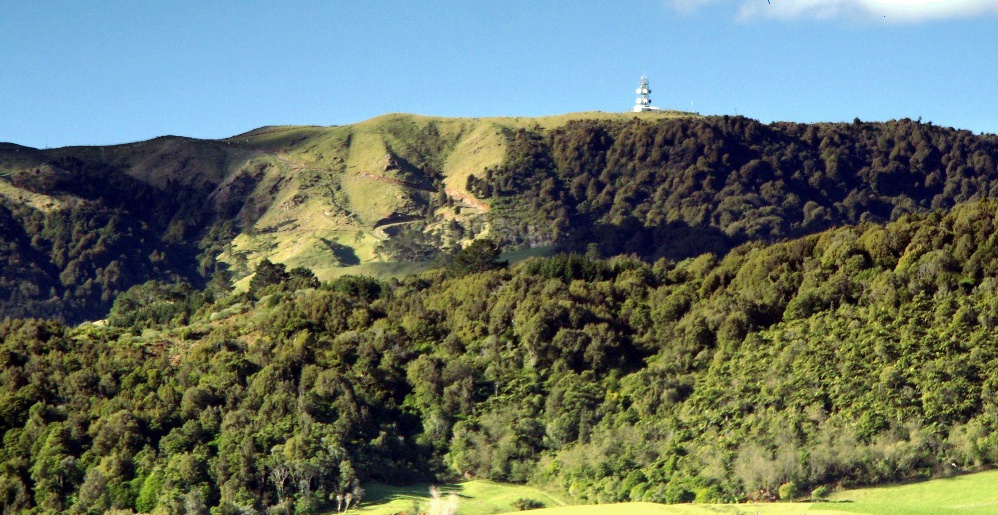
The Kaimai Range (sometimes referred to as the Kaimai Ranges) is a mountain range in the North Island of New Zealand. It is part of a series of ranges, with the Coromandel Range to the north and the Mamaku Ranges to the south. The Kaimai Range separates the Waikato in the west from the Bay of Plenty in the east.
The highest point of the range is Mount Te Aroha (953 m), at the foot of which is the town of Te Aroha. The range's terrain is rough, and only two roads pass over it: State Highway 2, across the northern end of the range through Karangahake Gorge, and State Highway 29 from Tauranga to Hamilton. Mt Te Aroha can be described as the northern head peak of the Kaimai Range.
The New Zealand Ministry for Culture and Heritage gives a translation of "eat fermented food" for Kaimāī.
The Kaimai Ranges feature in local Māori folklore. The name Te Aroha translates from Māori as Te - The & Aroha - Love. Literally "the love". The name comes from a Māori legend that the sun god - male - loved the moon goddess - female. They never could see each another due to the planets positions. One day the moon goddess came to earth to see the sun god, knowing the risks, was turned to stone as the daylight came. Hers was the ultimate expression of love: Te Aroha in Māori. This is why on the Kaimai Range, to the right of Mt Te Aroha is a high skyline silhouetted rock that from afar is shaped as a woman. It is known locally as the rock of Hinemoa.
Within the Kaimai Ranges the Hendersons Tramline loop track follows the route of bush tramlines and haul lines once used to extract logs from the bush. The walk includes forest and clearings near the fringe of the park. A side track off the main walk leads down to the base of a waterfall and a large swimming hole. Also some 10–16 km, on the Gordon backroad from te Aroha is a four-wheel drive track named Thomsons track, that takes venturers from the foothills around manawaru to the ranges top, where a large swimming hole is present.
The Kaimai Range is the result of a fault that uplifted primarily andesitic rocks from long-extinct volcanoes. This fault has not been active for about 140,000 years and started more than a million years ago. In pre-European times, the area was densely forested by trees such as kauri, mataī and tawa, and was a home for birds such as kererū, tūī, kākā and kiwi.
Kaimai statistical area, which does not include the entire range, covers 327.89 km2 (126.60 sq mi) and had an estimated population of 2,280 as of June 2025, with a population density of 7.0 people per km2.
Kaimai had a population of 2,148 in the 2023 New Zealand census, an increase of 120 people (5.9%) since the 2018 census, and an increase of 396 people (22.6%) since the 2013 census. There were 1,101 males, 1,038 females, and 6 people of other genders in 705 dwellings. 1.7% of people identified as LGBTIQ+. The median age was 41.8 years (compared with 38.1 years nationally). There were 414 people (19.3%) aged under 15 years, 351 (16.3%) aged 15 to 29, 1,077 (50.1%) aged 30 to 64, and 306 (14.2%) aged 65 or older.
Hub AI
Kaimai Range AI simulator
(@Kaimai Range_simulator)
Kaimai Range
The Kaimai Range (sometimes referred to as the Kaimai Ranges) is a mountain range in the North Island of New Zealand. It is part of a series of ranges, with the Coromandel Range to the north and the Mamaku Ranges to the south. The Kaimai Range separates the Waikato in the west from the Bay of Plenty in the east.
The highest point of the range is Mount Te Aroha (953 m), at the foot of which is the town of Te Aroha. The range's terrain is rough, and only two roads pass over it: State Highway 2, across the northern end of the range through Karangahake Gorge, and State Highway 29 from Tauranga to Hamilton. Mt Te Aroha can be described as the northern head peak of the Kaimai Range.
The New Zealand Ministry for Culture and Heritage gives a translation of "eat fermented food" for Kaimāī.
The Kaimai Ranges feature in local Māori folklore. The name Te Aroha translates from Māori as Te - The & Aroha - Love. Literally "the love". The name comes from a Māori legend that the sun god - male - loved the moon goddess - female. They never could see each another due to the planets positions. One day the moon goddess came to earth to see the sun god, knowing the risks, was turned to stone as the daylight came. Hers was the ultimate expression of love: Te Aroha in Māori. This is why on the Kaimai Range, to the right of Mt Te Aroha is a high skyline silhouetted rock that from afar is shaped as a woman. It is known locally as the rock of Hinemoa.
Within the Kaimai Ranges the Hendersons Tramline loop track follows the route of bush tramlines and haul lines once used to extract logs from the bush. The walk includes forest and clearings near the fringe of the park. A side track off the main walk leads down to the base of a waterfall and a large swimming hole. Also some 10–16 km, on the Gordon backroad from te Aroha is a four-wheel drive track named Thomsons track, that takes venturers from the foothills around manawaru to the ranges top, where a large swimming hole is present.
The Kaimai Range is the result of a fault that uplifted primarily andesitic rocks from long-extinct volcanoes. This fault has not been active for about 140,000 years and started more than a million years ago. In pre-European times, the area was densely forested by trees such as kauri, mataī and tawa, and was a home for birds such as kererū, tūī, kākā and kiwi.
Kaimai statistical area, which does not include the entire range, covers 327.89 km2 (126.60 sq mi) and had an estimated population of 2,280 as of June 2025, with a population density of 7.0 people per km2.
Kaimai had a population of 2,148 in the 2023 New Zealand census, an increase of 120 people (5.9%) since the 2018 census, and an increase of 396 people (22.6%) since the 2013 census. There were 1,101 males, 1,038 females, and 6 people of other genders in 705 dwellings. 1.7% of people identified as LGBTIQ+. The median age was 41.8 years (compared with 38.1 years nationally). There were 414 people (19.3%) aged under 15 years, 351 (16.3%) aged 15 to 29, 1,077 (50.1%) aged 30 to 64, and 306 (14.2%) aged 65 or older.
Recent media