
Recent from talks
Kirkmichael, Perth and Kinross
Knowledge base stats:
Talk channels stats:
Members stats:
Kirkmichael, Perth and Kinross
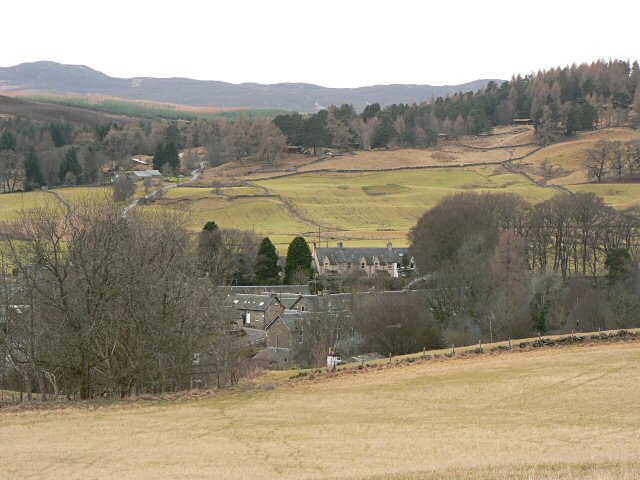
Kirkmichael is a village located in Strathardle, Perth and Kinross, Scotland. It is 13 miles (21 kilometres) north-northwest of Blairgowrie and 12 miles (19 kilometres) east-northeast of Pitlochry on the A924 Bridge of Cally to Pitlochry road, and is linked to the A93 Perth to Aberdeen road by the B950. The village is centred around Kirkmichael Bridge over the River Ardle.
The name Kirkmichael means church of (Saint) Michael; the Gaelic name is Cill Mhìcheil. The village dates back over a thousand years and was at one time an important market in the cattle trade between the Highlands and Lowlands with various drove roads converging on the village. The holding pens were on the rough ground known as the Market Moor near Whitefield and the market itself was on the grass area of Williamston, once common ground but now privately owned. Money traditionally had to be exchanged over running water and this was done at the nearby Sillerburn.
The area became popular as a holiday resort following Queen Victoria's building of Balmoral Castle in nearby Deeside and many of the local shooting lodges, or "big houses" as they are known, were built at that time. Traditionally they were occupied for "the season" of August and September, which included the all-important Glorious Twelfth, when grouse shooting started.
The village is split into two by the River Ardle. On the north side is the A924 (Main Street) with Kirkmichael parish church and graveyard, Session House community centre, Kirkmichael Hotel, shop, garage and traditional properties including the former police station and old dairy dating from the 19th century. On the south side are the primary school, Bannerfield, the fire station, the original part of the village known as Williamston, the village hall, the derelict Free Kirk, more recent properties in Sillerburn Road and Whitefield View, Sillerburn Cemetery, Balnald and Balnakilly. The population is approximately 150.
The original village, known as Williamston, sits above the school on the old road from Blairgowrie to Blair Atholl, which entered the village past the Hall and Old Kirk and exited by the road to Balnakilly. The original inn sat here at the School Corner on the village green which is now private property. The old road now forms part of the Cateran Trail long-distance trail, a circular route taking in Blairgowrie, Bridge of Cally, Kirkmichael, Enochdhu, Spittal of Glenshee, Kirkton of Glenisla and Alyth, which takes around five days to walk.
Kirkmichael Primary School sits on the south side of the bridge. It was built in 1850 but enlarged in 1877 by James C. Walker and again by Blairgowrie architect Lake Falconer in 1912. The school's catchment area currently incorporates Strathardle, Kirkmichael, Glenshee, Blacklunans, Bridge of Cally and Enochdhu. Until the latter part of the 20th century the catchment area also had schools at Straloch, Ballintuim, Strone of Cally, Blackwater and Glenshee but these are all closed with pupils bussed to Kirkmichael. Pupils continue their secondary school education at Blairgowrie High School. Over its lifetime, the school has been extended from a single-storey to a two-storey building, and in 2007 the new nursery and the primary 1-3 building were added. The grounds contain an all-weather sports court, which is available for public use outwith school hours.
The Church of Scotland parish kirk dates back to the 1791 and is built on a site used for worship for over one thousand years. It is surrounded by the original graveyard which contains graves dating back many centuries. The east end of the graveyard, which does not have headstones or individual graves, is the site of a mass burial plot for the victims of the Black Death plague of 1348 and has never been reopened. Sillerburn Cemetery, on Balnald Road, was opened in the 1950s and, as of 2022, contains around fifty graves. Kirkmichael parish was first linked with Straloch, then with Glenshee/Bridge of Cally and finally with Rattray, with the minister now using Rattray manse. The original manse, opposite the church, was sold in the 1970s and was replaced first by a bungalow in Glenshee then in the 1980s by another bungalow on the Balnald road.
The disused Free Kirk, known as the Duff Memorial Church, was built in 1890 by the breakaway Free Church of Scotland to replace their original church built on the same site in 1856. No one now knows why a replacement was built so soon. In 1928 the Free Kirk amalgamated back into the Church of Scotland, with the two churches being used on alternate Sundays until the Duff Memorial finally closed in the 1950s. It was then used as an agricultural building and in the late 1990s the Village Hall committee had an agreement to acquire the building, restore it to its former glory and provide the village with a 21st-century Community Hall as part of the National Lottery Millenium Hall Scheme to mark the 21st century. However it was put on the open market and sold to a property developer who then found his plan for conversion to a house was impossible, so the old kirk still sits empty and disused and is rapidly deteriorating. The Free Kirk manse became a SYHA youth hostel which for 30 years was very popular with cyclists and hikers until it was sold in the 1950s as a private house. Opposite the Old Manse is a cottage which was originally the parish poorhouse.
Hub AI
Kirkmichael, Perth and Kinross AI simulator
(@Kirkmichael, Perth and Kinross_simulator)
Kirkmichael, Perth and Kinross
Kirkmichael is a village located in Strathardle, Perth and Kinross, Scotland. It is 13 miles (21 kilometres) north-northwest of Blairgowrie and 12 miles (19 kilometres) east-northeast of Pitlochry on the A924 Bridge of Cally to Pitlochry road, and is linked to the A93 Perth to Aberdeen road by the B950. The village is centred around Kirkmichael Bridge over the River Ardle.
The name Kirkmichael means church of (Saint) Michael; the Gaelic name is Cill Mhìcheil. The village dates back over a thousand years and was at one time an important market in the cattle trade between the Highlands and Lowlands with various drove roads converging on the village. The holding pens were on the rough ground known as the Market Moor near Whitefield and the market itself was on the grass area of Williamston, once common ground but now privately owned. Money traditionally had to be exchanged over running water and this was done at the nearby Sillerburn.
The area became popular as a holiday resort following Queen Victoria's building of Balmoral Castle in nearby Deeside and many of the local shooting lodges, or "big houses" as they are known, were built at that time. Traditionally they were occupied for "the season" of August and September, which included the all-important Glorious Twelfth, when grouse shooting started.
The village is split into two by the River Ardle. On the north side is the A924 (Main Street) with Kirkmichael parish church and graveyard, Session House community centre, Kirkmichael Hotel, shop, garage and traditional properties including the former police station and old dairy dating from the 19th century. On the south side are the primary school, Bannerfield, the fire station, the original part of the village known as Williamston, the village hall, the derelict Free Kirk, more recent properties in Sillerburn Road and Whitefield View, Sillerburn Cemetery, Balnald and Balnakilly. The population is approximately 150.
The original village, known as Williamston, sits above the school on the old road from Blairgowrie to Blair Atholl, which entered the village past the Hall and Old Kirk and exited by the road to Balnakilly. The original inn sat here at the School Corner on the village green which is now private property. The old road now forms part of the Cateran Trail long-distance trail, a circular route taking in Blairgowrie, Bridge of Cally, Kirkmichael, Enochdhu, Spittal of Glenshee, Kirkton of Glenisla and Alyth, which takes around five days to walk.
Kirkmichael Primary School sits on the south side of the bridge. It was built in 1850 but enlarged in 1877 by James C. Walker and again by Blairgowrie architect Lake Falconer in 1912. The school's catchment area currently incorporates Strathardle, Kirkmichael, Glenshee, Blacklunans, Bridge of Cally and Enochdhu. Until the latter part of the 20th century the catchment area also had schools at Straloch, Ballintuim, Strone of Cally, Blackwater and Glenshee but these are all closed with pupils bussed to Kirkmichael. Pupils continue their secondary school education at Blairgowrie High School. Over its lifetime, the school has been extended from a single-storey to a two-storey building, and in 2007 the new nursery and the primary 1-3 building were added. The grounds contain an all-weather sports court, which is available for public use outwith school hours.
The Church of Scotland parish kirk dates back to the 1791 and is built on a site used for worship for over one thousand years. It is surrounded by the original graveyard which contains graves dating back many centuries. The east end of the graveyard, which does not have headstones or individual graves, is the site of a mass burial plot for the victims of the Black Death plague of 1348 and has never been reopened. Sillerburn Cemetery, on Balnald Road, was opened in the 1950s and, as of 2022, contains around fifty graves. Kirkmichael parish was first linked with Straloch, then with Glenshee/Bridge of Cally and finally with Rattray, with the minister now using Rattray manse. The original manse, opposite the church, was sold in the 1970s and was replaced first by a bungalow in Glenshee then in the 1980s by another bungalow on the Balnald road.
The disused Free Kirk, known as the Duff Memorial Church, was built in 1890 by the breakaway Free Church of Scotland to replace their original church built on the same site in 1856. No one now knows why a replacement was built so soon. In 1928 the Free Kirk amalgamated back into the Church of Scotland, with the two churches being used on alternate Sundays until the Duff Memorial finally closed in the 1950s. It was then used as an agricultural building and in the late 1990s the Village Hall committee had an agreement to acquire the building, restore it to its former glory and provide the village with a 21st-century Community Hall as part of the National Lottery Millenium Hall Scheme to mark the 21st century. However it was put on the open market and sold to a property developer who then found his plan for conversion to a house was impossible, so the old kirk still sits empty and disused and is rapidly deteriorating. The Free Kirk manse became a SYHA youth hostel which for 30 years was very popular with cyclists and hikers until it was sold in the 1950s as a private house. Opposite the Old Manse is a cottage which was originally the parish poorhouse.
Recent media