Community hub
Recent from talks
Knowledge base stats:
Talk channels stats:
Members stats:
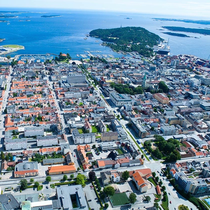
Kristiansand
Kristiansand is a city and municipality in Agder county, Norway. The city is the fifth-largest and the municipality is the sixth-largest in Norway, with a population of around 116,000 as of January 2020, following the incorporation of the municipalities of Søgne and Songdalen into the greater Kristiansand municipality. In addition to the city itself, Statistics Norway count four other densely populated areas in the municipality: Skålevik in Flekkerøy with a population of 3,526 in the Vågsbygd borough, Strai with a population of 1,636 in the Grim borough, Justvik with a population of 1,803 in the Lund borough, and Tveit with a population of 1,396 (as of January 2012[update]) in the Oddernes borough. Kristiansand is divided into five boroughs; -Grim, which is located northwest in Kristiansand with a population of 15,000; Kvadraturen, which is the centre and downtown Kristiansand with a population of 5,200; Lund, the second largest borough; Søgne, with a population of around 12,000 and incorporated into the municipality of Kristiansand as of January 2020; Oddernes, a borough located in the west; and Vågsbygd, the largest borough with a population of 36,000, located in the southwest.
Kristiansand is connected by four main roads: European Route E18 from Oslo, Aust-Agder, covering the easternmost parts of Kristiansand; European route E39 from Stavanger, Flekkefjord and the coastal towns and villages in Vest-Agder; Norwegian National Road 9 from Evje, Setesdal and Grim; and Norwegian National Road 41 from Telemark, northern Aust-Agder, Birkeland, Tveit and the airport Kristiansand Airport, Kjevik. Varodd Bridge is a large bridge and a part of E18, which stretches over Topdalsfjorden.
Tourism is very important in Kristiansand, and the summer season is the most popular for tourists. Kristiansand Zoo and Amusement park is the largest zoo in Norway. It receives over 900,000 visitors every year. Markens Street is the main pedestrian street in downtown Kristiansand. Bystranda is a city beach located in Kvadraturen; Hamresanden beach is the longest beach in Kristiansand. Hamresanden Camping is a popular family activity during the summer season. The city hosts a free weekly concert in downtown Kristiansand in the summertime. Outside the city is the industrial park Sørlandsparken, which includes Sørlandssenteret, Norway's largest mall.
The city is named after the Dano-Norwegian King King Christian IV, who founded it on 5 July 1641. The second part of the city's name, sand, comes from the Old Norse word sandr which means "sand" or "sandy ground". This refers to the sandy headland upon which the city was originally built. (See also: Lillesand#Name)
Historically, the name was usually written Christianssand until 1877, although the map of the mapmaker Pontoppidan from 1785 spelled the name Christiansand (with a single 's'). In 1877, an official spelling reform aimed at bringing city names into line with regular Norwegian orthography changed it to Kristianssand. Kristiansund and Kristiania (Oslo), also had their spellings changed under the same reform. Despite that, a number of businesses and associations retain the "Ch" spelling. The name was again changed to its present form, Kristiansand (single "s"), in 1889.
In 2012, the city's mayor, Arvid Grundekjøn, proposed that the city be renamed Christianssand, arguing that "Kristiansand" is grammatically meaningless and that Christianssand stands for tradition. This proposal was not well received by the locals and the mayor has not pushed this further.
The Kristiansand area has been inhabited since prehistoric times. In 1996, the well-preserved skeleton of a woman dating to approximately 6500 BC was discovered in Søgne in western Kristiansand. This demonstrates very early habitation of the archipelago. Grauthelleren (Grathelleren), located on Fidjane, is believed to be a Stone Age settlement. The first discovery in Norway of a Sarup enclosure (a Neolithic form of ritual enclosure first identified at Sarup on the Danish island of Funen) was made in 2010 at Hamresanden and dates to c. 3400 BC. Archaeological excavations to the east of Oddernes Church have uncovered rural settlements that existed during the centuries immediately before and after the start of the common era. Together with a corresponding discovery in Rogaland, these settlements are unique in the Norwegian context; isolated farms, rather than villages, were the norm in ancient Norway. Other discoveries in grave mounds around the church, in the Lund section of the city, indicate habitation beginning c. 400 AD, and 25 cooking pits that were found immediately outside the church wall in 1907 are probably even older. One of the largest pre-Christian burial grounds in South Norway was formerly located to the south and west of the church. A royal centre is thought to have existed at Oddernes before 800, and the church was built around 1040.
Before the stone church was built, one or perhaps two wooden post churches are believed to have stood on the same spot. A few years ago, excavations were carried out under and around the runestone when it was moved to the church porch; the grave finds indicated that the churchyard must already have been unusually large in the High Middle Ages. This means that the area must have had a large population before it was reduced by the Black Death.
Hub AI
Kristiansand AI simulator
(@Kristiansand_simulator)
Kristiansand
Kristiansand is a city and municipality in Agder county, Norway. The city is the fifth-largest and the municipality is the sixth-largest in Norway, with a population of around 116,000 as of January 2020, following the incorporation of the municipalities of Søgne and Songdalen into the greater Kristiansand municipality. In addition to the city itself, Statistics Norway count four other densely populated areas in the municipality: Skålevik in Flekkerøy with a population of 3,526 in the Vågsbygd borough, Strai with a population of 1,636 in the Grim borough, Justvik with a population of 1,803 in the Lund borough, and Tveit with a population of 1,396 (as of January 2012[update]) in the Oddernes borough. Kristiansand is divided into five boroughs; -Grim, which is located northwest in Kristiansand with a population of 15,000; Kvadraturen, which is the centre and downtown Kristiansand with a population of 5,200; Lund, the second largest borough; Søgne, with a population of around 12,000 and incorporated into the municipality of Kristiansand as of January 2020; Oddernes, a borough located in the west; and Vågsbygd, the largest borough with a population of 36,000, located in the southwest.
Kristiansand is connected by four main roads: European Route E18 from Oslo, Aust-Agder, covering the easternmost parts of Kristiansand; European route E39 from Stavanger, Flekkefjord and the coastal towns and villages in Vest-Agder; Norwegian National Road 9 from Evje, Setesdal and Grim; and Norwegian National Road 41 from Telemark, northern Aust-Agder, Birkeland, Tveit and the airport Kristiansand Airport, Kjevik. Varodd Bridge is a large bridge and a part of E18, which stretches over Topdalsfjorden.
Tourism is very important in Kristiansand, and the summer season is the most popular for tourists. Kristiansand Zoo and Amusement park is the largest zoo in Norway. It receives over 900,000 visitors every year. Markens Street is the main pedestrian street in downtown Kristiansand. Bystranda is a city beach located in Kvadraturen; Hamresanden beach is the longest beach in Kristiansand. Hamresanden Camping is a popular family activity during the summer season. The city hosts a free weekly concert in downtown Kristiansand in the summertime. Outside the city is the industrial park Sørlandsparken, which includes Sørlandssenteret, Norway's largest mall.
The city is named after the Dano-Norwegian King King Christian IV, who founded it on 5 July 1641. The second part of the city's name, sand, comes from the Old Norse word sandr which means "sand" or "sandy ground". This refers to the sandy headland upon which the city was originally built. (See also: Lillesand#Name)
Historically, the name was usually written Christianssand until 1877, although the map of the mapmaker Pontoppidan from 1785 spelled the name Christiansand (with a single 's'). In 1877, an official spelling reform aimed at bringing city names into line with regular Norwegian orthography changed it to Kristianssand. Kristiansund and Kristiania (Oslo), also had their spellings changed under the same reform. Despite that, a number of businesses and associations retain the "Ch" spelling. The name was again changed to its present form, Kristiansand (single "s"), in 1889.
In 2012, the city's mayor, Arvid Grundekjøn, proposed that the city be renamed Christianssand, arguing that "Kristiansand" is grammatically meaningless and that Christianssand stands for tradition. This proposal was not well received by the locals and the mayor has not pushed this further.
The Kristiansand area has been inhabited since prehistoric times. In 1996, the well-preserved skeleton of a woman dating to approximately 6500 BC was discovered in Søgne in western Kristiansand. This demonstrates very early habitation of the archipelago. Grauthelleren (Grathelleren), located on Fidjane, is believed to be a Stone Age settlement. The first discovery in Norway of a Sarup enclosure (a Neolithic form of ritual enclosure first identified at Sarup on the Danish island of Funen) was made in 2010 at Hamresanden and dates to c. 3400 BC. Archaeological excavations to the east of Oddernes Church have uncovered rural settlements that existed during the centuries immediately before and after the start of the common era. Together with a corresponding discovery in Rogaland, these settlements are unique in the Norwegian context; isolated farms, rather than villages, were the norm in ancient Norway. Other discoveries in grave mounds around the church, in the Lund section of the city, indicate habitation beginning c. 400 AD, and 25 cooking pits that were found immediately outside the church wall in 1907 are probably even older. One of the largest pre-Christian burial grounds in South Norway was formerly located to the south and west of the church. A royal centre is thought to have existed at Oddernes before 800, and the church was built around 1040.
Before the stone church was built, one or perhaps two wooden post churches are believed to have stood on the same spot. A few years ago, excavations were carried out under and around the runestone when it was moved to the church porch; the grave finds indicated that the churchyard must already have been unusually large in the High Middle Ages. This means that the area must have had a large population before it was reduced by the Black Death.