
Community hub
Recent from talks
Contribute something to knowledge base
Content stats: 0 posts, 0 articles, 1 media, 0 notes
Members stats: 0 subscribers, 0 contributors, 0 moderators, 0 supporters
Subscribers
Supporters
Contributors
Moderators
Hub AI
Landsat program AI simulator
(@Landsat program_simulator)
Hub AI
Landsat program AI simulator
(@Landsat program_simulator)
Landsat program
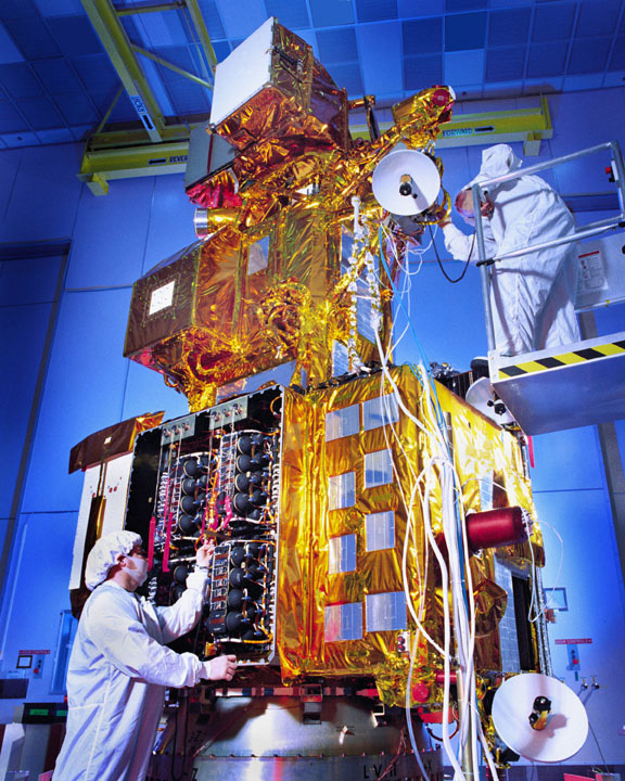
The Landsat program is the longest-running enterprise that has acquired satellite imagery of Earth. It is a joint NASA / USGS program. On 23 July 1972, the Earth Resources Technology Satellite was launched. This was eventually renamed to Landsat 1 in 1975. The most recent, Landsat 9, was launched on 27 September 2021.
The instruments on the Landsat satellites have acquired millions of images. The images, archived in the United States and at Landsat receiving stations around the world, are a unique resource for global change research and applications in agriculture, cartography, geology, forestry, regional planning, surveillance, and education, and can be viewed through the U.S. Geological Survey (USGS) "EarthExplorer" website. Landsat 7 data has eight spectral bands with spatial resolutions ranging from 15 to 60 m (49 to 197 ft); the temporal resolution is 16 days. Landsat images are usually divided into scenes for easy downloading. Each Landsat scene is about 115 miles long and 115 miles wide (or 100 nautical miles long and 100 nautical miles wide, or 185 kilometers long and 185 kilometers wide).
In 1965, William T. Pecora, the then director of the United States Geological Survey (USGS), proposed the idea of a remote sensing satellite program to gather facts about our planet's natural resources. Pecora stated that the program was "conceived in 1966 largely as a direct result of the demonstrated utility of the Mercury and Gemini orbital photography to Earth resource studies."
While weather satellites had been monitoring Earth's atmosphere since 1960 and were largely considered useful, there was no appreciation of terrain data from space until the mid-1960s. So, when Landsat 1 was proposed, it met with intense opposition from the Bureau of Budget and those who argued that high-altitude aircraft would be the fiscally responsible choice for Earth remote sensing. Concurrently, the Department of Defense feared that a civilian program such as Landsat would compromise the secrecy of its reconnaissance missions. Additionally, there were geopolitical concerns about photographing foreign countries without permission. In 1965, NASA began methodical investigations of Earth remote sensing using instruments mounted on planes.
In 1966, the USGS convinced the Secretary of the Interior, Stewart Udall, to announce that the Department of the Interior (DOI) would proceed with its Earth-observing satellite program. This savvy political stunt coerced NASA into expediting the building of Landsat. However, budgetary constraints and sensor disagreements between application agencies (notably the Department of Agriculture and DOI) again stymied the satellite construction process. Finally, by 1970, NASA had a green light to build a satellite. Remarkably, Landsat 1 was launched within only two years, heralding a new age of remote sensing of land from space.
The Hughes Aircraft Company from the Santa Barbara Research Center initiated, designed, and fabricated the first three Multispectral Scanners (MSS) in 1969. The first MSS prototype, designed by Virginia Norwood, was completed within nine months, in the fall of 1970. It was tested by scanning Half Dome at Yosemite National Park. Norwood was called "The Mother of Landsat" for this design work.
Working at NASA's Goddard Space Flight Center, Valerie L. Thomas managed the development of early Landsat image processing software systems and became the resident expert on the Computer Compatible Tapes, or CCTs, that were used to store early Landsat imagery. Thomas was one of the image processing specialists who facilitated the ambitious 'Large Area Crop Inventory Experiment', known as LACIE — a project that showed for the first time that global crop monitoring could be done through remote sensing with Landsat satellite imagery.
The program was initially called the Earth Resources Technology Satellites Program, which was used from 1966 to 1975. In 1975, the name was changed to Landsat. In 1979, Jimmy Carter's Presidential Directive 54 transferred Landsat operations from NASA to the National Oceanic and Atmospheric Administration (NOAA), recommended development of a long-term operational system with four additional satellites beyond Landsat 3, and recommended transition to private sector operation of Landsat. This occurred in 1985 when the Earth Observation Satellite Company (EOSAT), a partnership of Hughes Aircraft Company and RCA, was selected by NOAA to operate the Landsat system with a ten-year contract. EOSAT operated Landsat 4 and Landsat 5, had exclusive rights to market Landsat data, and was to build Landsats 6 and 7.
Landsat program
The Landsat program is the longest-running enterprise that has acquired satellite imagery of Earth. It is a joint NASA / USGS program. On 23 July 1972, the Earth Resources Technology Satellite was launched. This was eventually renamed to Landsat 1 in 1975. The most recent, Landsat 9, was launched on 27 September 2021.
The instruments on the Landsat satellites have acquired millions of images. The images, archived in the United States and at Landsat receiving stations around the world, are a unique resource for global change research and applications in agriculture, cartography, geology, forestry, regional planning, surveillance, and education, and can be viewed through the U.S. Geological Survey (USGS) "EarthExplorer" website. Landsat 7 data has eight spectral bands with spatial resolutions ranging from 15 to 60 m (49 to 197 ft); the temporal resolution is 16 days. Landsat images are usually divided into scenes for easy downloading. Each Landsat scene is about 115 miles long and 115 miles wide (or 100 nautical miles long and 100 nautical miles wide, or 185 kilometers long and 185 kilometers wide).
In 1965, William T. Pecora, the then director of the United States Geological Survey (USGS), proposed the idea of a remote sensing satellite program to gather facts about our planet's natural resources. Pecora stated that the program was "conceived in 1966 largely as a direct result of the demonstrated utility of the Mercury and Gemini orbital photography to Earth resource studies."
While weather satellites had been monitoring Earth's atmosphere since 1960 and were largely considered useful, there was no appreciation of terrain data from space until the mid-1960s. So, when Landsat 1 was proposed, it met with intense opposition from the Bureau of Budget and those who argued that high-altitude aircraft would be the fiscally responsible choice for Earth remote sensing. Concurrently, the Department of Defense feared that a civilian program such as Landsat would compromise the secrecy of its reconnaissance missions. Additionally, there were geopolitical concerns about photographing foreign countries without permission. In 1965, NASA began methodical investigations of Earth remote sensing using instruments mounted on planes.
In 1966, the USGS convinced the Secretary of the Interior, Stewart Udall, to announce that the Department of the Interior (DOI) would proceed with its Earth-observing satellite program. This savvy political stunt coerced NASA into expediting the building of Landsat. However, budgetary constraints and sensor disagreements between application agencies (notably the Department of Agriculture and DOI) again stymied the satellite construction process. Finally, by 1970, NASA had a green light to build a satellite. Remarkably, Landsat 1 was launched within only two years, heralding a new age of remote sensing of land from space.
The Hughes Aircraft Company from the Santa Barbara Research Center initiated, designed, and fabricated the first three Multispectral Scanners (MSS) in 1969. The first MSS prototype, designed by Virginia Norwood, was completed within nine months, in the fall of 1970. It was tested by scanning Half Dome at Yosemite National Park. Norwood was called "The Mother of Landsat" for this design work.
Working at NASA's Goddard Space Flight Center, Valerie L. Thomas managed the development of early Landsat image processing software systems and became the resident expert on the Computer Compatible Tapes, or CCTs, that were used to store early Landsat imagery. Thomas was one of the image processing specialists who facilitated the ambitious 'Large Area Crop Inventory Experiment', known as LACIE — a project that showed for the first time that global crop monitoring could be done through remote sensing with Landsat satellite imagery.
The program was initially called the Earth Resources Technology Satellites Program, which was used from 1966 to 1975. In 1975, the name was changed to Landsat. In 1979, Jimmy Carter's Presidential Directive 54 transferred Landsat operations from NASA to the National Oceanic and Atmospheric Administration (NOAA), recommended development of a long-term operational system with four additional satellites beyond Landsat 3, and recommended transition to private sector operation of Landsat. This occurred in 1985 when the Earth Observation Satellite Company (EOSAT), a partnership of Hughes Aircraft Company and RCA, was selected by NOAA to operate the Landsat system with a ten-year contract. EOSAT operated Landsat 4 and Landsat 5, had exclusive rights to market Landsat data, and was to build Landsats 6 and 7.
Recent media
Recent media