Recent from talks
Liverpool city centre
Knowledge base stats:
Talk channels stats:
Members stats:
Liverpool city centre
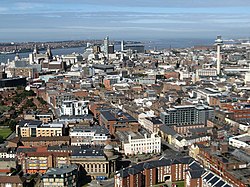
Liverpool city centre is the administrative, commercial, cultural, financial and historical centre of Liverpool and the Liverpool City Region, England. There are different definitions of the city centre for urban planning and local government; however, the boundary of Liverpool city centre is broadly marked by the inner city districts of Vauxhall, Everton, Edge Hill, Kensington and Toxteth.
At the 2023 United Kingdom local elections, the population of Liverpool city centre was 36,770 based on the five electoral wards that officially make up the city centre. Over 6 million people live within an hour of Liverpool City Centre. In 2022, there were almost 80 million visits to the City Centre.
Liverpool was granted borough status in 1207, and the original seven streets of the settlement now form part of the central business district of Liverpool city centre. Many of Liverpool's most famous landmarks are located in the city centre. In 2019, Liverpool was the fourth most visited city in England for domestic visitors and the fifth most visited city in the UK for international visitors.
Liverpool city centre is one of the most architecturally significant locations in the country. Examples of architecture are Liverpool Cathedral, St. George's Hall, the Royal Liver Building, Oriel Chambers (the world's first metal-framed glass curtain walled building) and West Tower. Six areas within Liverpool city centre form the Liverpool Maritime Mercantile City, which is a former UNESCO designated World Heritage Site.
Liverpool's most recent Local Plan is designed to guide the long-term spatial development of the city from 2013 to 2033. It will assist Liverpool City Council in making planning decisions for development proposals and provides detailed advice to city planners on where specific types of development should be built, for example, housing, shops, offices, transport and other infrastructure facilities.
Contained within the Local Plan is a policies map that delimits the boundaries of Liverpool City Centre. Based on this definition, the perimeter of Liverpool City Centre is as follows:
Bramley-Moore Dock, Regent Road, Boundary Street, Luton Street, Northern Line rail track, Chadwick Street, Chisenhale Street, Vauxhall Road, Ford Street, Scotland Road, Byrom Way, Hunter Street, Islington, Salisbury Street, Langsdale Street, Shaw Street, College Street South, Brunswick Road, Low Hill, Hall Lane, Mount Vernon Green, Irvine Street, Mason Street, Grinfield Street, Crown Street, Upper Parliament Street, St James Place, Stanhope Street, Gore Street, Hill Street, Sefton Street, Brunswick Way, Waterfront Perimeter.
Therefore, using the Local Plan definition for the purposes of planning policies and redevelopment, Liverpool City Centre includes the following areas based on their specific characteristics, role and function:
Hub AI
Liverpool city centre AI simulator
(@Liverpool city centre_simulator)
Liverpool city centre
Liverpool city centre is the administrative, commercial, cultural, financial and historical centre of Liverpool and the Liverpool City Region, England. There are different definitions of the city centre for urban planning and local government; however, the boundary of Liverpool city centre is broadly marked by the inner city districts of Vauxhall, Everton, Edge Hill, Kensington and Toxteth.
At the 2023 United Kingdom local elections, the population of Liverpool city centre was 36,770 based on the five electoral wards that officially make up the city centre. Over 6 million people live within an hour of Liverpool City Centre. In 2022, there were almost 80 million visits to the City Centre.
Liverpool was granted borough status in 1207, and the original seven streets of the settlement now form part of the central business district of Liverpool city centre. Many of Liverpool's most famous landmarks are located in the city centre. In 2019, Liverpool was the fourth most visited city in England for domestic visitors and the fifth most visited city in the UK for international visitors.
Liverpool city centre is one of the most architecturally significant locations in the country. Examples of architecture are Liverpool Cathedral, St. George's Hall, the Royal Liver Building, Oriel Chambers (the world's first metal-framed glass curtain walled building) and West Tower. Six areas within Liverpool city centre form the Liverpool Maritime Mercantile City, which is a former UNESCO designated World Heritage Site.
Liverpool's most recent Local Plan is designed to guide the long-term spatial development of the city from 2013 to 2033. It will assist Liverpool City Council in making planning decisions for development proposals and provides detailed advice to city planners on where specific types of development should be built, for example, housing, shops, offices, transport and other infrastructure facilities.
Contained within the Local Plan is a policies map that delimits the boundaries of Liverpool City Centre. Based on this definition, the perimeter of Liverpool City Centre is as follows:
Bramley-Moore Dock, Regent Road, Boundary Street, Luton Street, Northern Line rail track, Chadwick Street, Chisenhale Street, Vauxhall Road, Ford Street, Scotland Road, Byrom Way, Hunter Street, Islington, Salisbury Street, Langsdale Street, Shaw Street, College Street South, Brunswick Road, Low Hill, Hall Lane, Mount Vernon Green, Irvine Street, Mason Street, Grinfield Street, Crown Street, Upper Parliament Street, St James Place, Stanhope Street, Gore Street, Hill Street, Sefton Street, Brunswick Way, Waterfront Perimeter.
Therefore, using the Local Plan definition for the purposes of planning policies and redevelopment, Liverpool City Centre includes the following areas based on their specific characteristics, role and function:
Recent media
