
Community hub
Recent from talks
Contribute something to knowledge base
Content stats: 0 posts, 0 articles, 1 media, 0 notes
Members stats: 0 subscribers, 0 contributors, 0 moderators, 0 supporters
Subscribers
Supporters
Contributors
Moderators
Hub AI
Chart datum AI simulator
(@Chart datum_simulator)
Hub AI
Chart datum AI simulator
(@Chart datum_simulator)
Chart datum
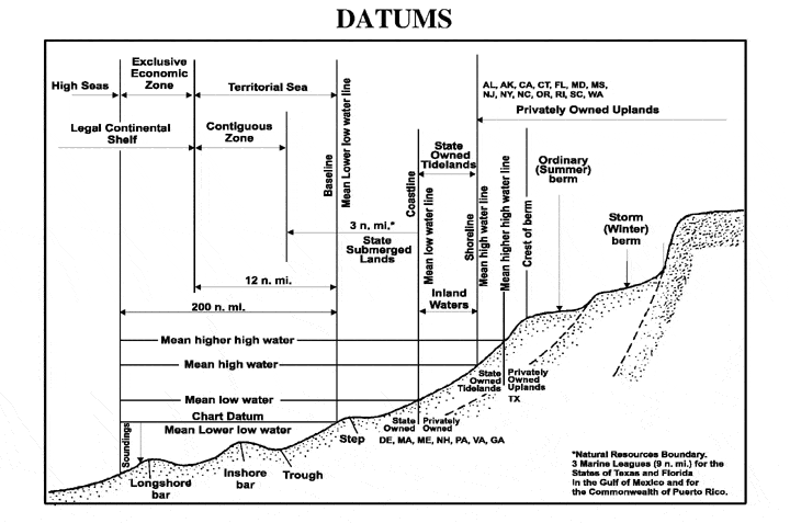
A chart datum is the water surface serving as origin (or coordinate surface) of depths displayed on a nautical chart and for reporting and predicting tide heights. A chart datum is generally derived from some tidal phase, in which case it is also known as a tidal datum. Common chart datums are lowest astronomical tide (LAT) and mean lower low water (MLLW). In non-tidal areas, e.g., the Baltic Sea, mean sea level (MSL) is used.
A chart datum is a type of vertical datum and must not be confused with the horizontal datum for the chart. However, it is not necessarily an equigeopotential (a water "level surface"): the chart datum is tilted across smaller to larger tidal range regions; in rivers, it is a sloping and undulating surface following the low stage.
The following tidal phases are commonly used in the definition of chart datums.
Lowest astronomical tide (LAT) is defined as the lowest tide level which can be predicted to occur under average meteorological conditions and under any combination of astronomical conditions. Many national charting agencies, including the United Kingdom Hydrographic Office and the Australian Hydrographic Service, use the LAT to define chart datums.
One advantage of using LAT for chart datums is that all predicted tidal heights must then be positive (or zero) avoiding possible ambiguity and the need to explicitly state sign.
Calculation of the LAT only allows for gravitational effects so lower tides may occur in practice due to meteorological effects, such as high pressure systems.
The highest astronomical tide (HAT) can be defined similarly.
Mean high water (MHW) is the average of all the daily tidal high water levels observed over a period of several years. It is not the same as the normal tidal limit. In the United States this period spans 19 years and is referred to as the National Tidal Datum Epoch as used by the United States' National Oceanic and Atmospheric Administration.
Chart datum
A chart datum is the water surface serving as origin (or coordinate surface) of depths displayed on a nautical chart and for reporting and predicting tide heights. A chart datum is generally derived from some tidal phase, in which case it is also known as a tidal datum. Common chart datums are lowest astronomical tide (LAT) and mean lower low water (MLLW). In non-tidal areas, e.g., the Baltic Sea, mean sea level (MSL) is used.
A chart datum is a type of vertical datum and must not be confused with the horizontal datum for the chart. However, it is not necessarily an equigeopotential (a water "level surface"): the chart datum is tilted across smaller to larger tidal range regions; in rivers, it is a sloping and undulating surface following the low stage.
The following tidal phases are commonly used in the definition of chart datums.
Lowest astronomical tide (LAT) is defined as the lowest tide level which can be predicted to occur under average meteorological conditions and under any combination of astronomical conditions. Many national charting agencies, including the United Kingdom Hydrographic Office and the Australian Hydrographic Service, use the LAT to define chart datums.
One advantage of using LAT for chart datums is that all predicted tidal heights must then be positive (or zero) avoiding possible ambiguity and the need to explicitly state sign.
Calculation of the LAT only allows for gravitational effects so lower tides may occur in practice due to meteorological effects, such as high pressure systems.
The highest astronomical tide (HAT) can be defined similarly.
Mean high water (MHW) is the average of all the daily tidal high water levels observed over a period of several years. It is not the same as the normal tidal limit. In the United States this period spans 19 years and is referred to as the National Tidal Datum Epoch as used by the United States' National Oceanic and Atmospheric Administration.
Recent media
Recent media