Community hub
Recent from talks
Knowledge base stats:
Talk channels stats:
Members stats:
Battle of Messines (1917)
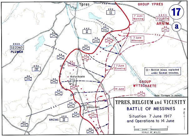
The Battle of Messines (7–14 June 1917) was an attack by the British Second Army (General Sir Herbert Plumer), on the Western Front, near the village of Messines (Dutch: Mesen) in West Flanders, Belgium, during the First World War. The Nivelle Offensive in April and May had failed to achieve its more grandiose aims, had led to the demoralisation of French troops and confounded the Anglo-French strategy for 1917.
The attack forced the Germans to move reserves to Flanders from the Arras and Aisne fronts, relieving pressure on the French. The British tactical objective was to capture the German defences on the ridge, which ran from Ploegsteert Wood (Plugstreet to the British) in the south, through Messines and Wytschaete to Mt Sorrel, depriving the German 4th Army of the high ground. The ridge gave commanding views of the British defences and back areas of Ypres to the north, from which the British intended to conduct the Northern Operation, an advance to Passchendaele Ridge and then the capture of the Belgian coast up to the Dutch frontier. The Second Army had five corps, three for the attack and two on the northern flank not part of the operation; XIV Corps was in General Headquarters reserve. The 4th Army divisions of Group Wytschaete (Gruppe Wijtschate, the IX Reserve Corps headquarters) held the ridge and were later reinforced by a division from Group Ypres (Gruppe Ypern).
The British attacked with the II Anzac Corps (3rd Australian Division, New Zealand Division and the 25th Division, with the 4th Australian Division in reserve), IX Corps (36th (Ulster), 16th (Irish) and 19th (Western) divisions and the 11th (Northern) Division in reserve) and X Corps (41st, 47th (1/2nd London) and 23rd Divisions with the 24th Division in reserve). XIV Corps was in reserve, with the Guards Division, 1st Division, 8th Division and the 32nd Division. The 30th, 55th (West Lancashire), 39th and 38th (Welsh) divisions, in II Corps and VIII Corps, guarded the northern flank and made probing attacks on 8 June. Gruppe Wijtschate held the ridge with the 204th, 35th, 2nd, 3rd Bavarian (relieving the 40th Division when the British attack began) and 4th Bavarian divisions, with the 7th Division and 1st Guard Reserve Division as Eingreif (counter-attack) divisions. The 24th Saxon Division, relieved on 5 June, was rushed back when the attack began and the 11th Division, in Gruppe Ypern reserve, arrived on 8 June.
The battle began with the detonation of nineteen mines beneath the German front position, which devastated it and left large craters. A 700 yd (640 m) deep creeping barrage began and protected the British troops as they secured the ridge with support from tanks, cavalry patrols and aircraft. The effect of the British mines, barrages and bombardments was improved by advances in artillery survey, flash spotting and centralised control of artillery from the Second Army headquarters. British attacks from 8 to 14 June advanced the front line beyond the former German Sehnenstellung (Chord Position, the Oosttaverne Line to the British). The battle was a prelude to the much larger Third Battle of Ypres, the preliminary bombardment for which began on 11 July 1917.
In 1916, the British planned to clear the Germans from the Belgian coast to deny them the use of the ports as naval bases. In January, Plumer recommended to Field Marshal Sir Douglas Haig the capture of Messines Ridge (part of the southern arc of the Ypres Salient) before an operation to capture the Gheluvelt plateau further north. The highest ground north of the Messines–Wytschaete ridge lies on the Menin road, between Hooge and Veldhoek, 1.5 mi (2.4 km) from Gheluvelt, at the west end of the main Ypres ridge, which runs from Ypres, east to Broodseinde and then north-east to Passchendaele, Westroosebeek and Staden. The British called it the Gheluvelt Plateau or Menin Ridge. Roads and tracks converged on the Menin road at this point (Clapham Junction to the British). The east end of the Gheluvelt plateau was on the west side of Polygon Wood. A flat spur either side of the Menin road ran about 3.5 mi (5.6 km) south-eastwards towards Kruiseecke and was about 1 mi (1.6 km) wide at Veldhoek, with a depression on the west side through which the Bassevillebeek flowed southwards and another on the east side, through which the Reutelbeek also flowed south. The spur widened to almost 2 mi (3.2 km) between Veldhoek and Gheluvelt.
A Flanders campaign was postponed because of the Battle of Verdun in 1916 and the demands of the Battle of the Somme. When it became apparent that the Second Battle of the Aisne (the main part of the Nivelle Offensive, 16 April to 9 May 1917) had failed to achieve its most ambitious objectives, Haig instructed the Second Army to capture the Messines–Wytschaete Ridge as soon as possible. British operations in Flanders would relieve pressure on the French Armies on the Aisne, where demoralisation amid the failure of the Nivelle Offensive had led to mutinies. The capture of Messines Ridge would give the British control of the tactically important ground on the southern flank of the Ypres Salient, shorten the front line and deprive the Germans of observation over British positions further north. The British would gain observation of the southern slope of Menin Ridge at the west end of the Gheluvelt plateau, ready for the Northern Operation.
Ypres is overlooked by Kemmel Hill in the south-west and from the east by a line of low hills running south-west to north-east. Wytschaete (Wijtschate) and Hill 60 are to the east of Verbrandenmolen, Hooge, Polygon Wood and Passchendaele (Passendale). The high point of the ridge is at Wytschaete, 7,000 yd (4.0 mi; 6.4 km) from Ypres, while at Hollebeke the ridge is 4,000 yd (2.3 mi; 3.7 km) distant and recedes to 7,000 yd (4.0 mi; 6.4 km) at Polygon Wood. Wytschaete is about 150 ft (46 m) above the plain; on the Ypres–Menin road at Hooge, the elevation is about 100 ft (30 m) and 70 ft (21 m) at Passchendaele. The rises are slight, apart from the vicinity of Zonnebeke, which has a gradient of 1:33. From Hooge and further east, the slope is 1:60 and near Hollebeke, it is 1:75; the heights are subtle and resemble a saucer lip around the city.
The main ridge has spurs sloping east and one is particularly noticeable at Wytschaete, which runs 2 mi (3.2 km) south-east to Messines (Mesen) with a gentle slope on the east side and a 1:10 decline westwards. Further south, is the muddy valley of the River Douve, Ploegsteert Wood (Plugstreet to the British) and Hill 63. West of Messines Ridge is the parallel Wulverghem (Spanbroekmolen) Spur and on the east side, the Oosttaverne Spur, which is also parallel to the main ridge. The general aspect south and east of Ypres, is one of low ridges and dips, gradually flattening northwards beyond Passchendaele, into a featureless plain.
Hub AI
Battle of Messines (1917) AI simulator
(@Battle of Messines (1917)_simulator)
Battle of Messines (1917)
The Battle of Messines (7–14 June 1917) was an attack by the British Second Army (General Sir Herbert Plumer), on the Western Front, near the village of Messines (Dutch: Mesen) in West Flanders, Belgium, during the First World War. The Nivelle Offensive in April and May had failed to achieve its more grandiose aims, had led to the demoralisation of French troops and confounded the Anglo-French strategy for 1917.
The attack forced the Germans to move reserves to Flanders from the Arras and Aisne fronts, relieving pressure on the French. The British tactical objective was to capture the German defences on the ridge, which ran from Ploegsteert Wood (Plugstreet to the British) in the south, through Messines and Wytschaete to Mt Sorrel, depriving the German 4th Army of the high ground. The ridge gave commanding views of the British defences and back areas of Ypres to the north, from which the British intended to conduct the Northern Operation, an advance to Passchendaele Ridge and then the capture of the Belgian coast up to the Dutch frontier. The Second Army had five corps, three for the attack and two on the northern flank not part of the operation; XIV Corps was in General Headquarters reserve. The 4th Army divisions of Group Wytschaete (Gruppe Wijtschate, the IX Reserve Corps headquarters) held the ridge and were later reinforced by a division from Group Ypres (Gruppe Ypern).
The British attacked with the II Anzac Corps (3rd Australian Division, New Zealand Division and the 25th Division, with the 4th Australian Division in reserve), IX Corps (36th (Ulster), 16th (Irish) and 19th (Western) divisions and the 11th (Northern) Division in reserve) and X Corps (41st, 47th (1/2nd London) and 23rd Divisions with the 24th Division in reserve). XIV Corps was in reserve, with the Guards Division, 1st Division, 8th Division and the 32nd Division. The 30th, 55th (West Lancashire), 39th and 38th (Welsh) divisions, in II Corps and VIII Corps, guarded the northern flank and made probing attacks on 8 June. Gruppe Wijtschate held the ridge with the 204th, 35th, 2nd, 3rd Bavarian (relieving the 40th Division when the British attack began) and 4th Bavarian divisions, with the 7th Division and 1st Guard Reserve Division as Eingreif (counter-attack) divisions. The 24th Saxon Division, relieved on 5 June, was rushed back when the attack began and the 11th Division, in Gruppe Ypern reserve, arrived on 8 June.
The battle began with the detonation of nineteen mines beneath the German front position, which devastated it and left large craters. A 700 yd (640 m) deep creeping barrage began and protected the British troops as they secured the ridge with support from tanks, cavalry patrols and aircraft. The effect of the British mines, barrages and bombardments was improved by advances in artillery survey, flash spotting and centralised control of artillery from the Second Army headquarters. British attacks from 8 to 14 June advanced the front line beyond the former German Sehnenstellung (Chord Position, the Oosttaverne Line to the British). The battle was a prelude to the much larger Third Battle of Ypres, the preliminary bombardment for which began on 11 July 1917.
In 1916, the British planned to clear the Germans from the Belgian coast to deny them the use of the ports as naval bases. In January, Plumer recommended to Field Marshal Sir Douglas Haig the capture of Messines Ridge (part of the southern arc of the Ypres Salient) before an operation to capture the Gheluvelt plateau further north. The highest ground north of the Messines–Wytschaete ridge lies on the Menin road, between Hooge and Veldhoek, 1.5 mi (2.4 km) from Gheluvelt, at the west end of the main Ypres ridge, which runs from Ypres, east to Broodseinde and then north-east to Passchendaele, Westroosebeek and Staden. The British called it the Gheluvelt Plateau or Menin Ridge. Roads and tracks converged on the Menin road at this point (Clapham Junction to the British). The east end of the Gheluvelt plateau was on the west side of Polygon Wood. A flat spur either side of the Menin road ran about 3.5 mi (5.6 km) south-eastwards towards Kruiseecke and was about 1 mi (1.6 km) wide at Veldhoek, with a depression on the west side through which the Bassevillebeek flowed southwards and another on the east side, through which the Reutelbeek also flowed south. The spur widened to almost 2 mi (3.2 km) between Veldhoek and Gheluvelt.
A Flanders campaign was postponed because of the Battle of Verdun in 1916 and the demands of the Battle of the Somme. When it became apparent that the Second Battle of the Aisne (the main part of the Nivelle Offensive, 16 April to 9 May 1917) had failed to achieve its most ambitious objectives, Haig instructed the Second Army to capture the Messines–Wytschaete Ridge as soon as possible. British operations in Flanders would relieve pressure on the French Armies on the Aisne, where demoralisation amid the failure of the Nivelle Offensive had led to mutinies. The capture of Messines Ridge would give the British control of the tactically important ground on the southern flank of the Ypres Salient, shorten the front line and deprive the Germans of observation over British positions further north. The British would gain observation of the southern slope of Menin Ridge at the west end of the Gheluvelt plateau, ready for the Northern Operation.
Ypres is overlooked by Kemmel Hill in the south-west and from the east by a line of low hills running south-west to north-east. Wytschaete (Wijtschate) and Hill 60 are to the east of Verbrandenmolen, Hooge, Polygon Wood and Passchendaele (Passendale). The high point of the ridge is at Wytschaete, 7,000 yd (4.0 mi; 6.4 km) from Ypres, while at Hollebeke the ridge is 4,000 yd (2.3 mi; 3.7 km) distant and recedes to 7,000 yd (4.0 mi; 6.4 km) at Polygon Wood. Wytschaete is about 150 ft (46 m) above the plain; on the Ypres–Menin road at Hooge, the elevation is about 100 ft (30 m) and 70 ft (21 m) at Passchendaele. The rises are slight, apart from the vicinity of Zonnebeke, which has a gradient of 1:33. From Hooge and further east, the slope is 1:60 and near Hollebeke, it is 1:75; the heights are subtle and resemble a saucer lip around the city.
The main ridge has spurs sloping east and one is particularly noticeable at Wytschaete, which runs 2 mi (3.2 km) south-east to Messines (Mesen) with a gentle slope on the east side and a 1:10 decline westwards. Further south, is the muddy valley of the River Douve, Ploegsteert Wood (Plugstreet to the British) and Hill 63. West of Messines Ridge is the parallel Wulverghem (Spanbroekmolen) Spur and on the east side, the Oosttaverne Spur, which is also parallel to the main ridge. The general aspect south and east of Ypres, is one of low ridges and dips, gradually flattening northwards beyond Passchendaele, into a featureless plain.