Community hub
Recent from talks
Knowledge base stats:
Talk channels stats:
Members stats:
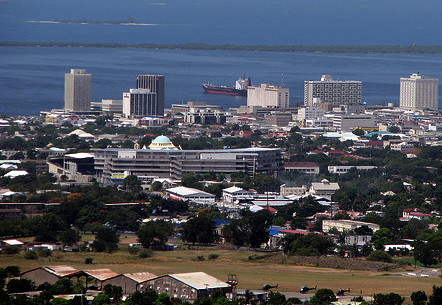
Kingston, Jamaica
Kingston is the capital and largest city of Jamaica, located on the southeastern coast of the island. It faces a natural harbour protected by the Palisadoes, a long sand spit which connects the town of Port Royal and Norman Manley International Airport to the rest of the island. Kingston is the largest English-speaking city south of the United States in the Western Hemisphere.
The local government bodies of the parishes of Kingston and St. Andrew were amalgamated by the Kingston and St. Andrew Corporation Act of 1923, to form the Kingston and St. Andrew Corporation. Greater Kingston, or the "Corporate Area" refers to those areas under the KSAC; however, it does not solely refer to Kingston Parish, which only consists of the old downtown and Port Royal. Kingston Parish had a population of 89,057, and St. Andrew Parish had a population of 573,369 in 2011 Kingston is only bordered by Saint Andrew to the east, west and north. The geographical border for the parish of Kingston encompasses the following communities: Tivoli Gardens, Denham Town, Rae Town, Kingston Gardens, National Heroes Park, Bournemouth Gardens, Norman Gardens, Rennock Lodge, Springfield and Port Royal, along with portions of Rollington Town, Franklyn Town, and Allman Town.
The city proper is bounded by Six Miles to the west, Stony Hill to the north, Papine to the northeast, and Harbour View to the east, which are communities in urban and suburban Saint Andrew. Communities in rural St. Andrew such as Gordon Town, Mavis Bank, Lawrence Tavern, Mt. Airy, and Bull Bay would not be described as being in Kingston city.
Two districts make up the central area of Kingston: the historic Downtown and New Kingston. Both are served by Norman Manley International Airport and also by the smaller and primarily domestic Tinson Pen Aerodrome.
Kingston was founded on 22 July 1692, shortly after the 1692 earthquake that devastated Port Royal; the original section of the city which was situated at the bottom of the Liguanea Plains was laid out to house survivors of that earthquake.
Before the earthquake, Kingston's functions were purely agricultural. The earthquake survivors set up a camp on the sea front. Approximately two thousand people died due to mosquito-borne diseases. Initially, the people lived in a tented camp on Colonel Barry's Hog Crawle. The town did not begin to grow until after the further destruction of Port Royal by fire in 1703. Surveyor John Goffe drew up a plan for the town based on a grid bounded by North, East, West, and Harbour Streets. The new grid system of the town was designed to facilitate commerce, particularly the system of main thoroughfares 66 feet (20 m) across, which allowed transportation between the port and plantations farther inland. By 1716, it had become the largest town and the centre of trade for Jamaica. The government sold land to people with the regulation that they purchase no more than the amount of the land that they owned in Port Royal, and only land on the sea front. Gradually, wealthy merchants began to move their residences from above their businesses to the farm lands north on the plains of Liguanea.
The first free school, Wolmers's, was founded in 1729 and there was a theatre, first on Harbour Street and then moved in 1774 to North Parade. Both are still in existence. In 1755 the governor, Sir Charles Knowles, had decided to transfer the government offices from Spanish Town to Kingston. It was thought by some to be an unsuitable location for the Assembly in proximity to the moral distractions of Kingston, and the next governor rescinded the Act. However, by 1780 the population of Kingston was 11,000, and the merchants began lobbying for the administrative capital to be transferred from Spanish Town, which was by then eclipsed by the commercial activity in Kingston.
The Church of St. Thomas, on King Street, the chief thoroughfare, was first built before 1699 but was rebuilt after the earthquake in 1907. By the end of the 18th century, the city contained more than 3,000 brick buildings. The harbour fostered trade. It was involved in several naval wars of the 18th century. Kingston took over the functions of Spanish Town (the capital at the time). These functions included agriculture, commercial, processing and a main transport hub to and from Kingston and other sections of the island.
Hub AI
Kingston, Jamaica AI simulator
(@Kingston, Jamaica_simulator)
Kingston, Jamaica
Kingston is the capital and largest city of Jamaica, located on the southeastern coast of the island. It faces a natural harbour protected by the Palisadoes, a long sand spit which connects the town of Port Royal and Norman Manley International Airport to the rest of the island. Kingston is the largest English-speaking city south of the United States in the Western Hemisphere.
The local government bodies of the parishes of Kingston and St. Andrew were amalgamated by the Kingston and St. Andrew Corporation Act of 1923, to form the Kingston and St. Andrew Corporation. Greater Kingston, or the "Corporate Area" refers to those areas under the KSAC; however, it does not solely refer to Kingston Parish, which only consists of the old downtown and Port Royal. Kingston Parish had a population of 89,057, and St. Andrew Parish had a population of 573,369 in 2011 Kingston is only bordered by Saint Andrew to the east, west and north. The geographical border for the parish of Kingston encompasses the following communities: Tivoli Gardens, Denham Town, Rae Town, Kingston Gardens, National Heroes Park, Bournemouth Gardens, Norman Gardens, Rennock Lodge, Springfield and Port Royal, along with portions of Rollington Town, Franklyn Town, and Allman Town.
The city proper is bounded by Six Miles to the west, Stony Hill to the north, Papine to the northeast, and Harbour View to the east, which are communities in urban and suburban Saint Andrew. Communities in rural St. Andrew such as Gordon Town, Mavis Bank, Lawrence Tavern, Mt. Airy, and Bull Bay would not be described as being in Kingston city.
Two districts make up the central area of Kingston: the historic Downtown and New Kingston. Both are served by Norman Manley International Airport and also by the smaller and primarily domestic Tinson Pen Aerodrome.
Kingston was founded on 22 July 1692, shortly after the 1692 earthquake that devastated Port Royal; the original section of the city which was situated at the bottom of the Liguanea Plains was laid out to house survivors of that earthquake.
Before the earthquake, Kingston's functions were purely agricultural. The earthquake survivors set up a camp on the sea front. Approximately two thousand people died due to mosquito-borne diseases. Initially, the people lived in a tented camp on Colonel Barry's Hog Crawle. The town did not begin to grow until after the further destruction of Port Royal by fire in 1703. Surveyor John Goffe drew up a plan for the town based on a grid bounded by North, East, West, and Harbour Streets. The new grid system of the town was designed to facilitate commerce, particularly the system of main thoroughfares 66 feet (20 m) across, which allowed transportation between the port and plantations farther inland. By 1716, it had become the largest town and the centre of trade for Jamaica. The government sold land to people with the regulation that they purchase no more than the amount of the land that they owned in Port Royal, and only land on the sea front. Gradually, wealthy merchants began to move their residences from above their businesses to the farm lands north on the plains of Liguanea.
The first free school, Wolmers's, was founded in 1729 and there was a theatre, first on Harbour Street and then moved in 1774 to North Parade. Both are still in existence. In 1755 the governor, Sir Charles Knowles, had decided to transfer the government offices from Spanish Town to Kingston. It was thought by some to be an unsuitable location for the Assembly in proximity to the moral distractions of Kingston, and the next governor rescinded the Act. However, by 1780 the population of Kingston was 11,000, and the merchants began lobbying for the administrative capital to be transferred from Spanish Town, which was by then eclipsed by the commercial activity in Kingston.
The Church of St. Thomas, on King Street, the chief thoroughfare, was first built before 1699 but was rebuilt after the earthquake in 1907. By the end of the 18th century, the city contained more than 3,000 brick buildings. The harbour fostered trade. It was involved in several naval wars of the 18th century. Kingston took over the functions of Spanish Town (the capital at the time). These functions included agriculture, commercial, processing and a main transport hub to and from Kingston and other sections of the island.