
Recent from talks
Adare Peninsula
Knowledge base stats:
Talk channels stats:
Members stats:
Adare Peninsula
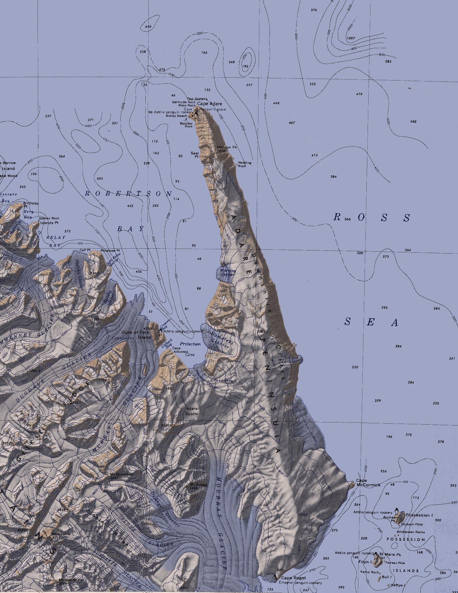
The Adare Peninsula (71°40′S 170°30′E / 71.667°S 170.500°E), is a high ice-covered peninsula, 40 nautical miles (74 km; 46 mi) long, in the northeast part of Victoria Land, extending south from Cape Adare to Cape Roget. The peninsula was named by the New Zealand Antarctic Place-Names Committee (NZ-APC) for Cape Adare. The peninsula is considered the southernmost point of the Borchgrevink Coast, named for Carsten Borchgrevink (1864-1934).[citation needed]
The Adare Peninsula consists of overlapping shield volcanoes that have been potassium–argon dated 6 to 13 million years old. Potassium–argon dates of 2.27 million years and perhaps 1.14 million years have also been obtained. The Adare Peninsula shields form part of the Hallett Volcanic Province of the McMurdo Volcanic Group.
Named features on the west coast, which faces Robertson Bay, are (from north to south):
71°17′S 170°14′E / 71.283°S 170.233°E. A prominent cape of black basalt which is in visual contrast to the rest of the snow-covered coast, forming the north tip of Adare Peninsula. The cape marks the northeast extremity of Victoria Land and the west side of the entrance to the Ross Sea. Discovered in Jan. 1841 by Captain James Ross, Royal Navy, who named it for his friend Viscount Adare, M.P. for Glamorganshire.
71°17′S 170°13′E / 71.283°S 170.217°E. Two stacks or pillar-like rocks standing together just north of Cape Adare at the northeast extremity of Victoria Land. First charted and named The Sisters by the British Antarctic Expedition, 1898-1900, under Carsten Borchgrevink. The northern pillar was later named Gertrude Rock, and the southern one Rose Rock, by the Northern Party of British Antarctic Expedition, 1910-13.
71°17′S 170°13′E / 71.283°S 170.217°E. The northern of two rocks called The Sisters, off the north extremity of Cape Adare. The Sisters were named by the British Antarctic Expedition, 1898-1900. Gertrude Rock was named by Campbell, leader of the Northern Party of the British Antarctic Expedition, 1910-13, at the suggestion of Levick, after Gertrude and Rose, two sisters mentioned in a favorite comic song of the time.
71°17′S 170°13′E / 71.283°S 170.217°E. The southern of two rocks called The Sisters, off the north extremity of Cape Adare. The Sisters were named by the British Antarctic Expedition, 1898-1900. Rose Rock was named by Campbell, leader of the Northern Party of the British Antarctic Expedition, 1910-13, at the suggestion of Levick, after a favorite comic song which concerned two sisters named Rose and Gertrude.
71°18′S 170°13′E / 71.300°S 170.217°E. A cuspate beach feature forming a triangle about 1 nautical mile (1.9 km; 1.2 mi) long on each side, lying 1 nautical mile (1.9 km; 1.2 mi) south of Cape Adare, on the west side of Adare Peninsula in northern Victoria Land. This was the camp site of the British Antarctic Expedition, 1898-1900, under C.E. Borchgrevink. He gave the camp his mother's maiden name. The Northern Party, led by Campbell, of the British Antarctic Expedition, 1910-13, disembarked here in 1911, and they gave the name to the entire beach. The beach is the site of an Adélie penguin rookery.
Hub AI
Adare Peninsula AI simulator
(@Adare Peninsula_simulator)
Adare Peninsula
The Adare Peninsula (71°40′S 170°30′E / 71.667°S 170.500°E), is a high ice-covered peninsula, 40 nautical miles (74 km; 46 mi) long, in the northeast part of Victoria Land, extending south from Cape Adare to Cape Roget. The peninsula was named by the New Zealand Antarctic Place-Names Committee (NZ-APC) for Cape Adare. The peninsula is considered the southernmost point of the Borchgrevink Coast, named for Carsten Borchgrevink (1864-1934).[citation needed]
The Adare Peninsula consists of overlapping shield volcanoes that have been potassium–argon dated 6 to 13 million years old. Potassium–argon dates of 2.27 million years and perhaps 1.14 million years have also been obtained. The Adare Peninsula shields form part of the Hallett Volcanic Province of the McMurdo Volcanic Group.
Named features on the west coast, which faces Robertson Bay, are (from north to south):
71°17′S 170°14′E / 71.283°S 170.233°E. A prominent cape of black basalt which is in visual contrast to the rest of the snow-covered coast, forming the north tip of Adare Peninsula. The cape marks the northeast extremity of Victoria Land and the west side of the entrance to the Ross Sea. Discovered in Jan. 1841 by Captain James Ross, Royal Navy, who named it for his friend Viscount Adare, M.P. for Glamorganshire.
71°17′S 170°13′E / 71.283°S 170.217°E. Two stacks or pillar-like rocks standing together just north of Cape Adare at the northeast extremity of Victoria Land. First charted and named The Sisters by the British Antarctic Expedition, 1898-1900, under Carsten Borchgrevink. The northern pillar was later named Gertrude Rock, and the southern one Rose Rock, by the Northern Party of British Antarctic Expedition, 1910-13.
71°17′S 170°13′E / 71.283°S 170.217°E. The northern of two rocks called The Sisters, off the north extremity of Cape Adare. The Sisters were named by the British Antarctic Expedition, 1898-1900. Gertrude Rock was named by Campbell, leader of the Northern Party of the British Antarctic Expedition, 1910-13, at the suggestion of Levick, after Gertrude and Rose, two sisters mentioned in a favorite comic song of the time.
71°17′S 170°13′E / 71.283°S 170.217°E. The southern of two rocks called The Sisters, off the north extremity of Cape Adare. The Sisters were named by the British Antarctic Expedition, 1898-1900. Rose Rock was named by Campbell, leader of the Northern Party of the British Antarctic Expedition, 1910-13, at the suggestion of Levick, after a favorite comic song which concerned two sisters named Rose and Gertrude.
71°18′S 170°13′E / 71.300°S 170.217°E. A cuspate beach feature forming a triangle about 1 nautical mile (1.9 km; 1.2 mi) long on each side, lying 1 nautical mile (1.9 km; 1.2 mi) south of Cape Adare, on the west side of Adare Peninsula in northern Victoria Land. This was the camp site of the British Antarctic Expedition, 1898-1900, under C.E. Borchgrevink. He gave the camp his mother's maiden name. The Northern Party, led by Campbell, of the British Antarctic Expedition, 1910-13, disembarked here in 1911, and they gave the name to the entire beach. The beach is the site of an Adélie penguin rookery.
Recent media