Community hub
Recent from talks
Knowledge base stats:
Talk channels stats:
Members stats:
Drainage system (geomorphology)
In geomorphology, drainage systems, also known as river systems, are the patterns formed by the streams, rivers, and lakes in a particular drainage basin. They are governed by the topography of land, whether a particular region is dominated by hard or soft rocks, and the gradient of the land. Geomorphologists and hydrologists often view streams as part of drainage basins (and sub-basins). This is the topographic region from which a stream receives runoff, throughflow, and its saturated equivalent, groundwater flow. The number, size, and shape of the drainage basins varies and the larger and more detailed the topographic map, the more information is available.
Per the lie of channels, drainage systems can fall into one of several categories, known as drainage patterns. These depend on the topography and geology of the land.
All forms of transitions can occur between parallel, dendritic, and trellis patterns.
A drainage system is described as accordant if its pattern correlates to the structure and relief of the landscape over which it flows.
A discordant system or pattern does not correlate to the topography and geology of the area. Discordant drainage patterns are classified into two main types: antecedent and superimposed, while ante position drainage patterns combine the two. In antecedent drainage, a river's vertical incision ability matches that of land uplift due to tectonic forces. Superimposed drainage develops differently: initially, a drainage system develops on a surface composed of 'younger' rocks, but due to denudation activities this surface of younger rocks is removed and the river continues to flow over a seemingly new surface, but one in fact made up of rocks of old geological formation.
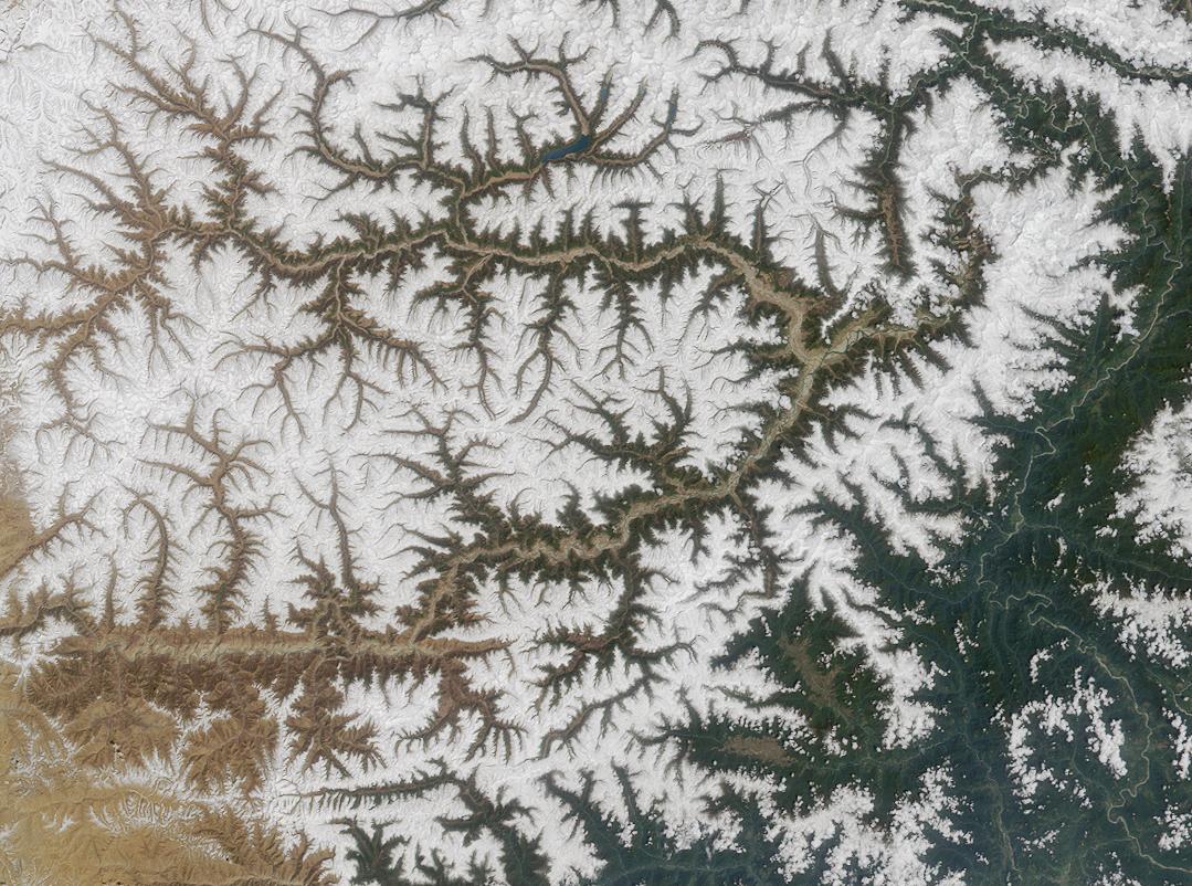
Dendritic drainage systems (from Ancient Greek δενδρίτης (dendrítēs) 'of or like a tree') are not straight and are the most common form of the drainage system. In this, there are many sub-tributaries (analogous to the twigs of a tree), which merge into tributaries of the main river (the branches and the trunk of the tree, respectively). They are seen to feed a river channel that matches and is strongly accordant to the overriding gradient of the land. Truly dendritic systems form in V-shaped valleys; as a result, the rock types must be impervious and non-porous.
A parallel drainage system occurs on elongate landforms like outcropping resistant rock bands, typically following natural faults or erosion (such as prevailing wind scars). The watercourses run swift and straight, with very few tributaries, and all flow in the same direction. This system forms on very long, uniform slopes, for instance, high rivers flowing southeast from the Aberdare Mountains in Kenya and many rivers of Myanmar.
This sometimes indicates a major fault that cuts across an area of steeply folded bedrock.
Hub AI
Drainage system (geomorphology) AI simulator
(@Drainage system (geomorphology)_simulator)
Drainage system (geomorphology)
In geomorphology, drainage systems, also known as river systems, are the patterns formed by the streams, rivers, and lakes in a particular drainage basin. They are governed by the topography of land, whether a particular region is dominated by hard or soft rocks, and the gradient of the land. Geomorphologists and hydrologists often view streams as part of drainage basins (and sub-basins). This is the topographic region from which a stream receives runoff, throughflow, and its saturated equivalent, groundwater flow. The number, size, and shape of the drainage basins varies and the larger and more detailed the topographic map, the more information is available.
Per the lie of channels, drainage systems can fall into one of several categories, known as drainage patterns. These depend on the topography and geology of the land.
All forms of transitions can occur between parallel, dendritic, and trellis patterns.
A drainage system is described as accordant if its pattern correlates to the structure and relief of the landscape over which it flows.
A discordant system or pattern does not correlate to the topography and geology of the area. Discordant drainage patterns are classified into two main types: antecedent and superimposed, while ante position drainage patterns combine the two. In antecedent drainage, a river's vertical incision ability matches that of land uplift due to tectonic forces. Superimposed drainage develops differently: initially, a drainage system develops on a surface composed of 'younger' rocks, but due to denudation activities this surface of younger rocks is removed and the river continues to flow over a seemingly new surface, but one in fact made up of rocks of old geological formation.
Dendritic drainage systems (from Ancient Greek δενδρίτης (dendrítēs) 'of or like a tree') are not straight and are the most common form of the drainage system. In this, there are many sub-tributaries (analogous to the twigs of a tree), which merge into tributaries of the main river (the branches and the trunk of the tree, respectively). They are seen to feed a river channel that matches and is strongly accordant to the overriding gradient of the land. Truly dendritic systems form in V-shaped valleys; as a result, the rock types must be impervious and non-porous.
A parallel drainage system occurs on elongate landforms like outcropping resistant rock bands, typically following natural faults or erosion (such as prevailing wind scars). The watercourses run swift and straight, with very few tributaries, and all flow in the same direction. This system forms on very long, uniform slopes, for instance, high rivers flowing southeast from the Aberdare Mountains in Kenya and many rivers of Myanmar.
This sometimes indicates a major fault that cuts across an area of steeply folded bedrock.