Recent from talks
Sal, Cape Verde
Knowledge base stats:
Talk channels stats:
Members stats:
Sal, Cape Verde
Sal (Portuguese for "salt") is an island in Cape Verde. Sal is a tourist destination with white sandy beaches and over 350 days of sunshine a year. It is one of the three sandy eastern islands of the Cape Verde archipelago in the central Atlantic Ocean, 350 miles (560 km) off the west coast of Africa. Cabo Verde is known for year-round kiteboarding, for the large reserve of Caretta turtles which hatch from July to September, and the music of Cesaria Evora. Cabo Verde is now the world's largest nesting aggregation for this turtle species, and Sal has the second-largest rookery.
For Europeans, the island was discovered on 3 December 1460 and named Llana ("flat"). This name was changed into the current "Sal" when the two large salt ponds (Pedra de Lume and Santa Maria) were discovered.[citation needed] The first three centuries after its discovery, the island was only sparsely inhabited; in 1720 there was a small fishing village near present Palmeira. This changed when the salt industry was developed at the end of the 18th century, starting in Pedra de Lume. Santa Maria was founded in the south of the island in 1830 by Manuel António Martins. During this time the salt industry thrived, with 30,000 tons of salt being exported in the early years. Most of the salt was exported to Brazil until its nationalization in 1887, Portuguese and French salt investors resumed salt production until 1984.
In 1939 Italy started constructing an airport to receive flights from Europe and South America. Construction was halted and ceased around World War II. The Portuguese bought the airport from the Italians and finished it in 1949. Northeast of the airport, workers from São Nicolau Island settled in a village named Preguiça, now part of Espargos. Hurricane Fred struck the island of Sal in late summer 2015, causing damage to houses, tourist facilities and ships.
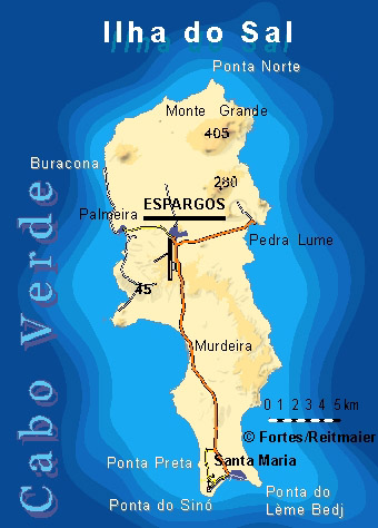
The island is 29.7 km long and 11.8 km wide. Its area is 219.84 km2 (84.88 sq mi). It is one of the three sandy eastern islands (Sal, Boa Vista and Maio) of the archipelago, with white sandy beaches. The island is fairly flat; its highest point is Monte Grande, at 406 m elevation. The uninhabited islet Ilhéu Rabo de Junco lies near the west coast of Sal. Saline marshes can be found in the Pedra de Lume crater and north of Santa Maria.
Sal Island has on average 350 days of sunshine a year. Winds mainly blow from the northeast. However, some days do also have clouds, but they tend to be scattered and seldom bring rain. The 'rainy season' is from July to mid-October, although rainfall is still low.
Administratively, the island of Sal is covered by one municipality, Concelho do Sal. This municipality consists of one freguesia (civil parish), Nossa Senhora das Dores, which also covers the whole island. The municipality of Sal was created in 1935, when it was separated from the Municipality of Boa Vista. The municipal seat was originally at Santa Maria, but Espargos became the municipal seat in the 1970s.[citation needed]
The freguesia is subdivided into the following settlements:
Since 2016, the Movement for Democracy (MpD) is the ruling party of the municipality. The results of the latest elections, in 2016:
Hub AI
Sal, Cape Verde AI simulator
(@Sal, Cape Verde_simulator)
Sal, Cape Verde
Sal (Portuguese for "salt") is an island in Cape Verde. Sal is a tourist destination with white sandy beaches and over 350 days of sunshine a year. It is one of the three sandy eastern islands of the Cape Verde archipelago in the central Atlantic Ocean, 350 miles (560 km) off the west coast of Africa. Cabo Verde is known for year-round kiteboarding, for the large reserve of Caretta turtles which hatch from July to September, and the music of Cesaria Evora. Cabo Verde is now the world's largest nesting aggregation for this turtle species, and Sal has the second-largest rookery.
For Europeans, the island was discovered on 3 December 1460 and named Llana ("flat"). This name was changed into the current "Sal" when the two large salt ponds (Pedra de Lume and Santa Maria) were discovered.[citation needed] The first three centuries after its discovery, the island was only sparsely inhabited; in 1720 there was a small fishing village near present Palmeira. This changed when the salt industry was developed at the end of the 18th century, starting in Pedra de Lume. Santa Maria was founded in the south of the island in 1830 by Manuel António Martins. During this time the salt industry thrived, with 30,000 tons of salt being exported in the early years. Most of the salt was exported to Brazil until its nationalization in 1887, Portuguese and French salt investors resumed salt production until 1984.
In 1939 Italy started constructing an airport to receive flights from Europe and South America. Construction was halted and ceased around World War II. The Portuguese bought the airport from the Italians and finished it in 1949. Northeast of the airport, workers from São Nicolau Island settled in a village named Preguiça, now part of Espargos. Hurricane Fred struck the island of Sal in late summer 2015, causing damage to houses, tourist facilities and ships.
The island is 29.7 km long and 11.8 km wide. Its area is 219.84 km2 (84.88 sq mi). It is one of the three sandy eastern islands (Sal, Boa Vista and Maio) of the archipelago, with white sandy beaches. The island is fairly flat; its highest point is Monte Grande, at 406 m elevation. The uninhabited islet Ilhéu Rabo de Junco lies near the west coast of Sal. Saline marshes can be found in the Pedra de Lume crater and north of Santa Maria.
Sal Island has on average 350 days of sunshine a year. Winds mainly blow from the northeast. However, some days do also have clouds, but they tend to be scattered and seldom bring rain. The 'rainy season' is from July to mid-October, although rainfall is still low.
Administratively, the island of Sal is covered by one municipality, Concelho do Sal. This municipality consists of one freguesia (civil parish), Nossa Senhora das Dores, which also covers the whole island. The municipality of Sal was created in 1935, when it was separated from the Municipality of Boa Vista. The municipal seat was originally at Santa Maria, but Espargos became the municipal seat in the 1970s.[citation needed]
The freguesia is subdivided into the following settlements:
Since 2016, the Movement for Democracy (MpD) is the ruling party of the municipality. The results of the latest elections, in 2016:
Recent media