
Recent from talks
Saline Valley
Knowledge base stats:
Talk channels stats:
Members stats:
Saline Valley
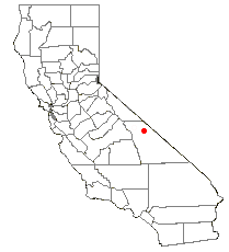
Saline Valley is a large, deep, and arid graben, about 27 miles (43 km) in length, in the northern Mojave Desert of California, a narrow, northwest–southeast-trending tectonic sink defined by fault-block mountains. Most of it became a part of Death Valley National Park when the park was expanded in 1994. This area had previously been administered by the Bureau of Land Management. It is located northwest of Death Valley proper, south of Eureka Valley, and east of the Owens Valley. The valley's lowest elevations are about 1,000 ft (300 m) and it lies in the rain shadow of the 14,000 ft (4,300 m) Sierra Nevada range, plus the 11,000 ft (3,400 m) Inyo Mountains bordering the valley on the west.
A large dry lake occupies the center of the valley. The west end of the lake supports a salt marsh, which contains a variety of plant and animal life. The marsh is fed by a perennial stream from Hunter Canyon. North of the lake is a large area of low and sweeping sand dunes.
There are a number of hot springs in the northeast corner of the valley. The water temperature at the source of these springs averages at 107 °F (42 °C). Saline Valley's three main warm springs are reached by a primary road known as the Warm Springs Road or Painted Rock Road.
Lower Warm Springs is the largest, most developed, and most popular dispersed camping area. Palm Spring is smaller and less crowded with great views of Saline Valley and the source feeds two tubs known as Wizard Pool and Volcano Pool. Upper Warm Spring, the smallest and least disturbed of the main springs, is a deep pool of lukewarm azure water surrounded by cattail, arrow-weed, and grasses, in full view of the Saline Range.
Saline Valley is a closed or endorheic basin. If filled with water it would be over 4,000 feet (1,200 m) deep, form a lake with a surface area of roughly 500 square miles (1,300 km2), and hold approximately 500,000,000 acre⋅ft (620 km3) of water.
Saline Valley was inhabited by the Ko'ongkatün Band of Timbisha Shoshone (also known as Panamint or Koso). One of their principal villages was known as Ko'on and located in Saline Valley, therefore the valley was named after the village and known as Ko'ongkatün (Ko'on + kantün - "possessing, characterized by" the village Ko'on) or simply Ko'on. The Timbisha Shoshone living at Ko'on were called Ko'ontsi (″People of the village Ko'on"). The village was abandoned in the early 20th century and the inhabitants moved to Darwin, California.
Saline Valley was a significant mineral source in the late 19th and early 20th centuries. The Conn and Trudo Borax Company mined borax from the salt marsh from 1874 to 1895. The remains of this site can be seen today as a few shallow pits near Saline Valley Road. Salt mining began in 1903 at the south end of the lake, and continued into the 1930s.
An electric aerial tram was constructed in 1911 to carry the salt 14 miles (23 km) over the Inyo Mountains to a terminus northeast of Keeler, California in the Owens Valley. It operated sporadically from 1913 to 1936, but ultimately proved to be too expensive to run. The tram, which was placed on the National Register of Historic Places in 1973, was the steepest ever constructed in the United States. It rose from an elevation of 1,100 feet (340 m) in Saline Valley to 8,500 feet (2,600 m) over the mountains, and then down to 3,600 feet (1,100 m). Route was south from Salt Lake to Daisy Canyon then southwest and terminated at the Southern Pacific RR between Dolomite and Swansea. In recent years it has been badly damaged by vandals.
Hub AI
Saline Valley AI simulator
(@Saline Valley_simulator)
Saline Valley
Saline Valley is a large, deep, and arid graben, about 27 miles (43 km) in length, in the northern Mojave Desert of California, a narrow, northwest–southeast-trending tectonic sink defined by fault-block mountains. Most of it became a part of Death Valley National Park when the park was expanded in 1994. This area had previously been administered by the Bureau of Land Management. It is located northwest of Death Valley proper, south of Eureka Valley, and east of the Owens Valley. The valley's lowest elevations are about 1,000 ft (300 m) and it lies in the rain shadow of the 14,000 ft (4,300 m) Sierra Nevada range, plus the 11,000 ft (3,400 m) Inyo Mountains bordering the valley on the west.
A large dry lake occupies the center of the valley. The west end of the lake supports a salt marsh, which contains a variety of plant and animal life. The marsh is fed by a perennial stream from Hunter Canyon. North of the lake is a large area of low and sweeping sand dunes.
There are a number of hot springs in the northeast corner of the valley. The water temperature at the source of these springs averages at 107 °F (42 °C). Saline Valley's three main warm springs are reached by a primary road known as the Warm Springs Road or Painted Rock Road.
Lower Warm Springs is the largest, most developed, and most popular dispersed camping area. Palm Spring is smaller and less crowded with great views of Saline Valley and the source feeds two tubs known as Wizard Pool and Volcano Pool. Upper Warm Spring, the smallest and least disturbed of the main springs, is a deep pool of lukewarm azure water surrounded by cattail, arrow-weed, and grasses, in full view of the Saline Range.
Saline Valley is a closed or endorheic basin. If filled with water it would be over 4,000 feet (1,200 m) deep, form a lake with a surface area of roughly 500 square miles (1,300 km2), and hold approximately 500,000,000 acre⋅ft (620 km3) of water.
Saline Valley was inhabited by the Ko'ongkatün Band of Timbisha Shoshone (also known as Panamint or Koso). One of their principal villages was known as Ko'on and located in Saline Valley, therefore the valley was named after the village and known as Ko'ongkatün (Ko'on + kantün - "possessing, characterized by" the village Ko'on) or simply Ko'on. The Timbisha Shoshone living at Ko'on were called Ko'ontsi (″People of the village Ko'on"). The village was abandoned in the early 20th century and the inhabitants moved to Darwin, California.
Saline Valley was a significant mineral source in the late 19th and early 20th centuries. The Conn and Trudo Borax Company mined borax from the salt marsh from 1874 to 1895. The remains of this site can be seen today as a few shallow pits near Saline Valley Road. Salt mining began in 1903 at the south end of the lake, and continued into the 1930s.
An electric aerial tram was constructed in 1911 to carry the salt 14 miles (23 km) over the Inyo Mountains to a terminus northeast of Keeler, California in the Owens Valley. It operated sporadically from 1913 to 1936, but ultimately proved to be too expensive to run. The tram, which was placed on the National Register of Historic Places in 1973, was the steepest ever constructed in the United States. It rose from an elevation of 1,100 feet (340 m) in Saline Valley to 8,500 feet (2,600 m) over the mountains, and then down to 3,600 feet (1,100 m). Route was south from Salt Lake to Daisy Canyon then southwest and terminated at the Southern Pacific RR between Dolomite and Swansea. In recent years it has been badly damaged by vandals.
Recent media