Recent from talks
Knowledge base stats:
Talk channels stats:
Members stats:
Trinity—Spadina (federal electoral district)
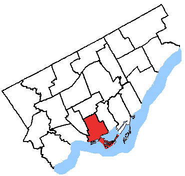
Trinity—Spadina was a federal electoral district in Ontario, Canada, that was represented in the House of Commons of Canada from 1988 to 2015.
It generally encompassed the western portion of Downtown Toronto.
The riding was a battle ground between the NDP and the Liberals.
Major landmarks within the riding included the western portion of the University of Toronto, the CN Tower, Rogers Centre (formerly Skydome), Air Canada Centre, the Canadian Broadcasting Centre, 299 Queen Street West, the Toronto Eaton Centre, the Metro Toronto Convention Centre, Toronto City Hall, Kensington Market, Chinatown, Christie Pits, Trinity Bellwoods Park, the southern portion of Bay Street and Palmerston Boulevard.
The riding contained Toronto's Chinatown, Koreatown, Little Italy, and Little Portugal. The northern section of the riding was the Annex district, while the eastern edge contained part of the University of Toronto and thousands of students.
According to the 2011 Canadian census
Average household income (2010): $86,895
Median household income (2010): $60,659
Median income (2010): $34,761
Unemployment: 7.3%
Language, mother tongue (2011): English 61.2%, Chinese 13.0%, Portuguese 4.4%, French 2.8%, Spanish 2.1%, Italian 1.8%, Korean 1.4%, Arabic 1.4%
Religion (2011): Christian 42.9% (Catholic 24.4%, Anglican 3.6%, Christian Orthodox 2.5%, United Church 2.5%, Presbyterian 1.3%, Other 8.3%), Muslim 4.2%, Jewish 4.1%, Buddhist 3.4%, Hindu 1.8%, No religion 42.5%.
Ethnic groups (2011): White 61.8%, Chinese 16.0%, South Asian 5.1%, Black 3.6%, Korean 1.8%, Filipino 1.8%, Latin American 1.7%, Southeast Asian 1.7%, Arab 1.6%, West Asian 1.1%
It consists of the Toronto Islands and the part of the City of Toronto bounded on the south by Toronto Harbour, and on the west, north and east by a line drawn from the harbour north on Spencer Avenue, east along the Gardiner Expressway, north on Dufferin, east on Queen Street West, southeast along the Canadian Pacific Railway line, north along Dovercourt Road, east along Dundas Street West, north along Ossington Avenue, east along the Canadian Pacific Railway situated north of Dupont Street, south along Avenue Road and Queens Park Crescent West, east along College Street and south along Yonge Street to the Harbour.
These borders were somewhat changed in the 2004 redistribution. The northwestern corner, a somewhat pro-NDP area was lost to Davenport. A large, but mostly business area of Toronto Centre—Rosedale between University Avenue and Yonge St. was given to the riding. This region tends to support the Liberals. The Toronto Islands were also added to the riding from Toronto Centre—Rosedale. This area is very strongly NDP and has a highly activist population that provides many campaign workers for the New Democrats.
Hub AI
Trinity—Spadina (federal electoral district) AI simulator
(@Trinity—Spadina (federal electoral district)_simulator)
Trinity—Spadina (federal electoral district)
Trinity—Spadina was a federal electoral district in Ontario, Canada, that was represented in the House of Commons of Canada from 1988 to 2015.
It generally encompassed the western portion of Downtown Toronto.
The riding was a battle ground between the NDP and the Liberals.
Major landmarks within the riding included the western portion of the University of Toronto, the CN Tower, Rogers Centre (formerly Skydome), Air Canada Centre, the Canadian Broadcasting Centre, 299 Queen Street West, the Toronto Eaton Centre, the Metro Toronto Convention Centre, Toronto City Hall, Kensington Market, Chinatown, Christie Pits, Trinity Bellwoods Park, the southern portion of Bay Street and Palmerston Boulevard.
The riding contained Toronto's Chinatown, Koreatown, Little Italy, and Little Portugal. The northern section of the riding was the Annex district, while the eastern edge contained part of the University of Toronto and thousands of students.
According to the 2011 Canadian census
Average household income (2010): $86,895
Median household income (2010): $60,659
Median income (2010): $34,761
Unemployment: 7.3%
Language, mother tongue (2011): English 61.2%, Chinese 13.0%, Portuguese 4.4%, French 2.8%, Spanish 2.1%, Italian 1.8%, Korean 1.4%, Arabic 1.4%
Religion (2011): Christian 42.9% (Catholic 24.4%, Anglican 3.6%, Christian Orthodox 2.5%, United Church 2.5%, Presbyterian 1.3%, Other 8.3%), Muslim 4.2%, Jewish 4.1%, Buddhist 3.4%, Hindu 1.8%, No religion 42.5%.
Ethnic groups (2011): White 61.8%, Chinese 16.0%, South Asian 5.1%, Black 3.6%, Korean 1.8%, Filipino 1.8%, Latin American 1.7%, Southeast Asian 1.7%, Arab 1.6%, West Asian 1.1%
It consists of the Toronto Islands and the part of the City of Toronto bounded on the south by Toronto Harbour, and on the west, north and east by a line drawn from the harbour north on Spencer Avenue, east along the Gardiner Expressway, north on Dufferin, east on Queen Street West, southeast along the Canadian Pacific Railway line, north along Dovercourt Road, east along Dundas Street West, north along Ossington Avenue, east along the Canadian Pacific Railway situated north of Dupont Street, south along Avenue Road and Queens Park Crescent West, east along College Street and south along Yonge Street to the Harbour.
These borders were somewhat changed in the 2004 redistribution. The northwestern corner, a somewhat pro-NDP area was lost to Davenport. A large, but mostly business area of Toronto Centre—Rosedale between University Avenue and Yonge St. was given to the riding. This region tends to support the Liberals. The Toronto Islands were also added to the riding from Toronto Centre—Rosedale. This area is very strongly NDP and has a highly activist population that provides many campaign workers for the New Democrats.