Recent from talks
Aller (Germany)
Knowledge base stats:
Talk channels stats:
Members stats:
Aller (Germany)
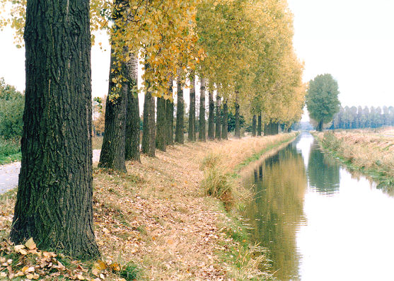
The Aller (pronounced [ˈalɐ] ⓘ) is a 215-kilometre-long (134 mi) river in the states of Saxony-Anhalt and Lower Saxony in Germany. It is a right-hand, and hence eastern, tributary of the Weser and is also its largest tributary. Its last 117 kilometres (73 mi) form the Lower Aller federal waterway (Bundeswasserstraße). The Aller was extensively straightened, widened and, in places, dyked during the 1960s to provide flood control of the river. In a 20-kilometre-long (12 mi) section near Gifhorn, the river meanders in its natural river bed.
The river's name, which was recorded in 781 as Alera, in 803 as Elera, in 1096 as Alara, has two possible derivations:
The Aller rises in the state of Saxony-Anhalt in the west of the region known as the Magdeburg Börde near Seehausen and north of Oschersleben (Bode). It has several source streams that run down the northeastern side of the Hohes Holz within the municipal boundaries of Wormsdorf (part of Gehringsdorf), Ovelgünne (part of Siegersleben) and Eggenstedt. The Eggenstedt tributary is the most southerly of the source streams. The nearest large centres of population in the source region are Helmstedt, about 20 kilometres (12 mi) northwest, and Magdeburg around 25 kilometres (16 mi) east.
Initially, the Aller flows rather like a canalised brook in a northwestern direction through low hills and intensively farmed arable fields. As it does, it passes the Flechtingen Hills to the east and another range of hills to the west that stretches from the Lappwald over the Hohes Holz as far as Oschersleben (Bode). The river passes the villages of Eilsleben and Weferlingen. After about 60 river kilometres (37 mi), it reaches Oebisfelde and the southern edge of the Drömling. After crossing the state border between Saxony-Anhalt and Lower Saxony, the Aller bends sharply southwest near Grafhorst. Here, the terrain is already only about 55 metres (180 ft) above sea level. Between here and its mouth, 150 kilometres (93 mi) away, its elevation drops by only about 40 metres (130 ft), so that the speed of the current is considerably reduced in Lower Saxony. Near Grafhorst, the Aller meets the Breslau-Magdeburg-Bremen glacial valley and then, for the most part, follows it. From here on, the river mainly runs through grassland.
Near Wolfsburg-Wendschott, the Aller passes under the Mittelland Canal in a culvert where there is a barrier that is impassable to fish. The Aller swings northwest again from Wolfsburg. In the area of the town it crosses the Allerpark and flows past the Allersee before flowing past the Barnbruch.
South of Weyhausen, the Aller Canal branches off the Aller. The canal was built between 1860 and 1863 and is about 18 kilometres (11 mi) long. It was supposed to drain the long-standing floods that were greatly feared at that time. The canal runs parallel to, and generally a few miles south of, the Aller, rejoining it near Brenneckenbrück (west of Gifhorn). The canal runs south past Gifhorn, whilst the Aller flows through the town. This 20-kilometre-long (12 mi) section, which parallels the Aller Canal, is the only section of the Aller that meanders in its natural river channel. Elsewhere, the Aller has been straightened and widened along its entire length from source to mouth. East of Gifhorn near Osloß it crosses under the Elbe Lateral Canal, which is carried over it on an aqueduct. After that it runs via Gifhorn to Müden, where it merges with the Oker.
The 30-kilometre-long (19 mi) section of the Aller from the mouth of the Oker to Celle is referred to as the Middle Aller (Mittelaller). After passing Wienhausen, it is navigable as far as Celle. Here, the river has so much water that there are barrages and the water power is extracted from the river using weirs.
The section of the river known as the Lower Aller (Unteraller) begins at Celle and runs for 120 kilometres (75 mi) to the Weser. The Lower Aller is a designated federal waterway (Bundeswasserstraße). The river is navigable from here to Winsen. Near Eickeloh a reaction ferry crosses the Aller and it is here that the Leine flows into the Aller. Upstream and downstream of Rethem, there are two groups of impressive meanders. Below them it passes Verden. About 4 kilometres (2.5 mi) northwest of the town, near Eißel, a village in the borough of Verden, the Aller finally discharges into the Weser. There are two Alte Allers, i. e. old branches of the Aller. One is on the left bank opposite Verden. The other is on the right bank and is the former lowest part of the course of the river.
Hub AI
Aller (Germany) AI simulator
(@Aller (Germany)_simulator)
Aller (Germany)
The Aller (pronounced [ˈalɐ] ⓘ) is a 215-kilometre-long (134 mi) river in the states of Saxony-Anhalt and Lower Saxony in Germany. It is a right-hand, and hence eastern, tributary of the Weser and is also its largest tributary. Its last 117 kilometres (73 mi) form the Lower Aller federal waterway (Bundeswasserstraße). The Aller was extensively straightened, widened and, in places, dyked during the 1960s to provide flood control of the river. In a 20-kilometre-long (12 mi) section near Gifhorn, the river meanders in its natural river bed.
The river's name, which was recorded in 781 as Alera, in 803 as Elera, in 1096 as Alara, has two possible derivations:
The Aller rises in the state of Saxony-Anhalt in the west of the region known as the Magdeburg Börde near Seehausen and north of Oschersleben (Bode). It has several source streams that run down the northeastern side of the Hohes Holz within the municipal boundaries of Wormsdorf (part of Gehringsdorf), Ovelgünne (part of Siegersleben) and Eggenstedt. The Eggenstedt tributary is the most southerly of the source streams. The nearest large centres of population in the source region are Helmstedt, about 20 kilometres (12 mi) northwest, and Magdeburg around 25 kilometres (16 mi) east.
Initially, the Aller flows rather like a canalised brook in a northwestern direction through low hills and intensively farmed arable fields. As it does, it passes the Flechtingen Hills to the east and another range of hills to the west that stretches from the Lappwald over the Hohes Holz as far as Oschersleben (Bode). The river passes the villages of Eilsleben and Weferlingen. After about 60 river kilometres (37 mi), it reaches Oebisfelde and the southern edge of the Drömling. After crossing the state border between Saxony-Anhalt and Lower Saxony, the Aller bends sharply southwest near Grafhorst. Here, the terrain is already only about 55 metres (180 ft) above sea level. Between here and its mouth, 150 kilometres (93 mi) away, its elevation drops by only about 40 metres (130 ft), so that the speed of the current is considerably reduced in Lower Saxony. Near Grafhorst, the Aller meets the Breslau-Magdeburg-Bremen glacial valley and then, for the most part, follows it. From here on, the river mainly runs through grassland.
Near Wolfsburg-Wendschott, the Aller passes under the Mittelland Canal in a culvert where there is a barrier that is impassable to fish. The Aller swings northwest again from Wolfsburg. In the area of the town it crosses the Allerpark and flows past the Allersee before flowing past the Barnbruch.
South of Weyhausen, the Aller Canal branches off the Aller. The canal was built between 1860 and 1863 and is about 18 kilometres (11 mi) long. It was supposed to drain the long-standing floods that were greatly feared at that time. The canal runs parallel to, and generally a few miles south of, the Aller, rejoining it near Brenneckenbrück (west of Gifhorn). The canal runs south past Gifhorn, whilst the Aller flows through the town. This 20-kilometre-long (12 mi) section, which parallels the Aller Canal, is the only section of the Aller that meanders in its natural river channel. Elsewhere, the Aller has been straightened and widened along its entire length from source to mouth. East of Gifhorn near Osloß it crosses under the Elbe Lateral Canal, which is carried over it on an aqueduct. After that it runs via Gifhorn to Müden, where it merges with the Oker.
The 30-kilometre-long (19 mi) section of the Aller from the mouth of the Oker to Celle is referred to as the Middle Aller (Mittelaller). After passing Wienhausen, it is navigable as far as Celle. Here, the river has so much water that there are barrages and the water power is extracted from the river using weirs.
The section of the river known as the Lower Aller (Unteraller) begins at Celle and runs for 120 kilometres (75 mi) to the Weser. The Lower Aller is a designated federal waterway (Bundeswasserstraße). The river is navigable from here to Winsen. Near Eickeloh a reaction ferry crosses the Aller and it is here that the Leine flows into the Aller. Upstream and downstream of Rethem, there are two groups of impressive meanders. Below them it passes Verden. About 4 kilometres (2.5 mi) northwest of the town, near Eißel, a village in the borough of Verden, the Aller finally discharges into the Weser. There are two Alte Allers, i. e. old branches of the Aller. One is on the left bank opposite Verden. The other is on the right bank and is the former lowest part of the course of the river.
Recent media