Recent from talks
Amargosa Valley
Knowledge base stats:
Talk channels stats:
Members stats:
Amargosa Valley
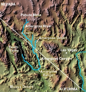
The Amargosa Valley is the valley through which the Amargosa River flows south, in Nye County, southwestern Nevada and Inyo County in the state of California. The south end is alternately called the "Amargosa River Valley'" or the "Tecopa Valley." Its northernmost point is around Beatty, Nevada and southernmost is Tecopa, California, where the Amargosa River enters into the Amargosa Canyon.
The Amargosa Valley ("the Valley") is located within the Basin and Range Province ("the Province") which is characterized by abrupt changes in elevation, alternating between narrow faulted mountain chains and flat arid valleys or basins. As is typical of the Province, the Valley is long from north to south and narrow from east to west. It lies to the east of Death Valley, separated from it by the Amargosa Range and Funeral Mountains.
The Valley lies within the Mohave Desert region of the Province. The more narrowly bounded Amargosa Desert forms the eastern portion of the Valley.
It is not known when the first humans settled in the Amargosa Desert. Ancient campsites have been found that date back at least 10,000 years, to the end of the last ice age. Recent[when?] examination of archaeological remains in the valley implies more extensive use by aboriginal peoples than had been previously estimated. Pottery and other artifacts have been found that date back from approximately 1000 A.D. to even earlier times. During the nineteenth century, two groups of Native Americans occupied the Amargosa Valley: the Southern Paiute and the Western Shoshone. Both were extremely adept at extracting a living from their marginal environment, subsisting on wild plant foods and supplemented by wild game.
The Old Spanish Trail and the later wagon road called the Old Mormon Road or Salt Lake Road, ran through the south end of Amargosa Valley, passing from Resting Springs, east of present-day Tecopa, 7 miles to Willow Spring on the east bank of the canyon of the Amargosa River (then called Saleratus Creek), below Tecopa and above the mouth of China Ranch Wash.
After the Donner Party's disastrous winter of 1847 in the Sierra Nevada mountains, which happened just before the news of California gold became public, a loose group arrived in October 1849 at the Great Salt Lake. They organized under the guidance of a Captain Hunt to head for the San Bernardino–Los Angeles area. The best alternative to risking the Donner route was to try an end run to the south of the Sierras. The Old Spanish Trail had long been used by Indians, traders, explorers, and mountain men as a convenient but rough route, confined to horseback and pack animals, to California. It ran north from Santa Fe to the Salt Lake area then back south along the edge of the mountains to San Diego, and had been used ever since the days of Cabeza De Vaca's journey through the country.
Leaving the Salt Lake area, they were overtaken by another party led by a guide named Captain Smith. He assured them that a more direct route across the southern deserts existed which was quite passable for wagons and showed them a copy of John C. Fremont's map of his explorations. The map had a large portion, then known as "The Great American Desert", left blank with the word "unexplored" across it. On this Smith's friend Barney Ward had drawn in a trail which showed plenty of graze for the animals, and adequate water for all with a description of the clear cool waters of Owens river and Lake Owens. The route would take them north and west of the then unknown Death Valley. Then, over Walker's Pass into California. Unfortunately, this map showed a fictitious mountain range, north of the Old Spanish Trail to Los Angeles and running roughly east–west across central Nevada, and it may have been this non-existent mountain range that contributed to the emigrant's decision to chance leaving the established trail, under the assumption that water, and grass for the oxen, would be easier to locate along the base of the mountains. In later times, the exploration and mapping of Nevada would show that all of the mountain ranges in central Nevada run north–south, directly across the path the Bennett-Arcane Party took.
The party was led by William L. Manly, Rev. James Brier, and Asahel Bennett, all experienced outdoorsmen and farmers out of the Wisconsin farm country who decided to risk it on the assurances that Smith, with the map, would accompany them. Hunt objected, but agreed to stay on as long as he was needed. Soon after their leaving Salt Lake, Smith's group split off as did their guide Hunt as the country got really rough for wagon passage with the main group of less adventurous emigrants and the map. Smith and Hunt both arrived with their parties in San Bernardino after tough but quick journeys around Death Valley. Manly, Brier, and Bennett led straight on into the Amargosa desert. They were followed by another small group, the Wade family party who stayed back one day. Not having to scout or break trail, the Wades had an easy journey compared to the others.
Hub AI
Amargosa Valley AI simulator
(@Amargosa Valley_simulator)
Amargosa Valley
The Amargosa Valley is the valley through which the Amargosa River flows south, in Nye County, southwestern Nevada and Inyo County in the state of California. The south end is alternately called the "Amargosa River Valley'" or the "Tecopa Valley." Its northernmost point is around Beatty, Nevada and southernmost is Tecopa, California, where the Amargosa River enters into the Amargosa Canyon.
The Amargosa Valley ("the Valley") is located within the Basin and Range Province ("the Province") which is characterized by abrupt changes in elevation, alternating between narrow faulted mountain chains and flat arid valleys or basins. As is typical of the Province, the Valley is long from north to south and narrow from east to west. It lies to the east of Death Valley, separated from it by the Amargosa Range and Funeral Mountains.
The Valley lies within the Mohave Desert region of the Province. The more narrowly bounded Amargosa Desert forms the eastern portion of the Valley.
It is not known when the first humans settled in the Amargosa Desert. Ancient campsites have been found that date back at least 10,000 years, to the end of the last ice age. Recent[when?] examination of archaeological remains in the valley implies more extensive use by aboriginal peoples than had been previously estimated. Pottery and other artifacts have been found that date back from approximately 1000 A.D. to even earlier times. During the nineteenth century, two groups of Native Americans occupied the Amargosa Valley: the Southern Paiute and the Western Shoshone. Both were extremely adept at extracting a living from their marginal environment, subsisting on wild plant foods and supplemented by wild game.
The Old Spanish Trail and the later wagon road called the Old Mormon Road or Salt Lake Road, ran through the south end of Amargosa Valley, passing from Resting Springs, east of present-day Tecopa, 7 miles to Willow Spring on the east bank of the canyon of the Amargosa River (then called Saleratus Creek), below Tecopa and above the mouth of China Ranch Wash.
After the Donner Party's disastrous winter of 1847 in the Sierra Nevada mountains, which happened just before the news of California gold became public, a loose group arrived in October 1849 at the Great Salt Lake. They organized under the guidance of a Captain Hunt to head for the San Bernardino–Los Angeles area. The best alternative to risking the Donner route was to try an end run to the south of the Sierras. The Old Spanish Trail had long been used by Indians, traders, explorers, and mountain men as a convenient but rough route, confined to horseback and pack animals, to California. It ran north from Santa Fe to the Salt Lake area then back south along the edge of the mountains to San Diego, and had been used ever since the days of Cabeza De Vaca's journey through the country.
Leaving the Salt Lake area, they were overtaken by another party led by a guide named Captain Smith. He assured them that a more direct route across the southern deserts existed which was quite passable for wagons and showed them a copy of John C. Fremont's map of his explorations. The map had a large portion, then known as "The Great American Desert", left blank with the word "unexplored" across it. On this Smith's friend Barney Ward had drawn in a trail which showed plenty of graze for the animals, and adequate water for all with a description of the clear cool waters of Owens river and Lake Owens. The route would take them north and west of the then unknown Death Valley. Then, over Walker's Pass into California. Unfortunately, this map showed a fictitious mountain range, north of the Old Spanish Trail to Los Angeles and running roughly east–west across central Nevada, and it may have been this non-existent mountain range that contributed to the emigrant's decision to chance leaving the established trail, under the assumption that water, and grass for the oxen, would be easier to locate along the base of the mountains. In later times, the exploration and mapping of Nevada would show that all of the mountain ranges in central Nevada run north–south, directly across the path the Bennett-Arcane Party took.
The party was led by William L. Manly, Rev. James Brier, and Asahel Bennett, all experienced outdoorsmen and farmers out of the Wisconsin farm country who decided to risk it on the assurances that Smith, with the map, would accompany them. Hunt objected, but agreed to stay on as long as he was needed. Soon after their leaving Salt Lake, Smith's group split off as did their guide Hunt as the country got really rough for wagon passage with the main group of less adventurous emigrants and the map. Smith and Hunt both arrived with their parties in San Bernardino after tough but quick journeys around Death Valley. Manly, Brier, and Bennett led straight on into the Amargosa desert. They were followed by another small group, the Wade family party who stayed back one day. Not having to scout or break trail, the Wades had an easy journey compared to the others.
Recent media