Recent from talks
Ariyalur
Knowledge base stats:
Talk channels stats:
Members stats:
Ariyalur
Ariyalur (Tamil: [aɾijaluːɾ]) is a town and district headquarters of Ariyalur district in the South Indian state of Tamil Nadu and is rich in limestone, surrounded with seven cement factories and two sugar factories. The town is located at a distance of 310 km (190 mi) from the state capital Chennai.
Ariyalur was a part of the erstwhile Trichinopoly District until India's independence in 1947 and Tiruchirappalli district until 1995, Perambalur district until 2007 and subsequently a part of the newly formed Ariyalur district. The town is a part of the fertile Cauvery Delta and the major profession in the town is agriculture.
Ariyalur is administered by a municipality established in 1994. As of 2011, the municipality covered an area of 7.62 km2 (2.94 sq mi) and had a population of 28,902. Ariyalur comes under the Ariyalur assembly constituency which elects a member to the Tamil Nadu Legislative Assembly once every five years and it is a part of the Chidambaram constituency which elects its Member of Parliament (MP) once in five years. Roadways are the major mode of transportation to the town and it also has rail connectivity which acts as a main station after Tiruchirappalli junction. The nearest seaport is Karaikal port, located 95 km (59 mi) away, while the nearest airport is the Tiruchirappalli International Airport, located 76 km (47 mi) away from the town.
Ariyalur town has a rich historical legacy, primarily associated with the later phases of the Chola dynasty. During the Chola period, the region was governed by the Paluvettaraiyar chiefs, who served as feudatories under Chola kings from Aditya I to Rajendra I. Their capital was Melapaluvur, located near present-day Ariyalur. This area was known for its administrative importance and proximity to Gangaikonda Cholapuram, the imperial capital established by Rajendra Chola I.
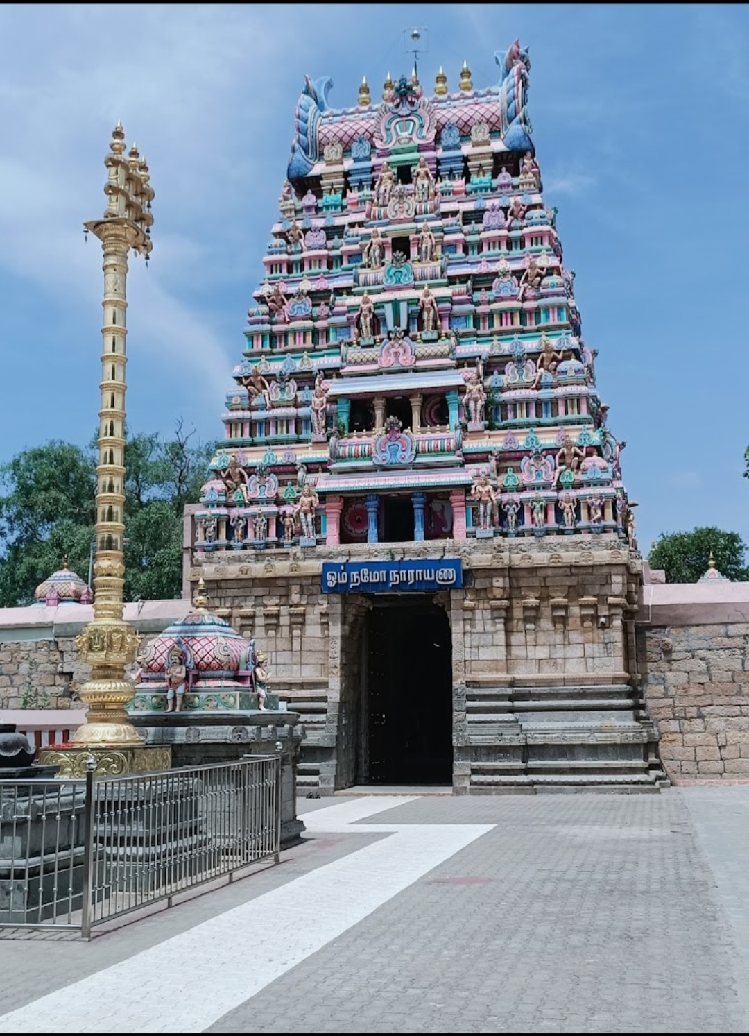
Following the decline of the Cholas, Ariyalur came under the rule of the Vijayanagara Empire and later the Nayaks of Madurai. The Vijayanagara Nayak rulers contributed to the construction of several temples in and around the town, most notably the Kothandaramar Temple, which reflects the architectural style of the period.
In the mid-eighteenth century, Ariyalur was one of the two important palayams (feudal estates) under the control of local Poligars. In 1741, when the Marathas invaded Tiruchirappalli, Chanda Sahib was captured. After his release in 1748, he became embroiled in a power struggle with Anwaruddin Khan and his son Muhammad Ali Khan Wallajah for control of the Carnatic region. During this conflict, the Nawab of Arcot accused the Poligars of Ariyalur and Udayarpalayam of defaulting on tribute payments and disloyalty. With British support, forces under Umdat-ul-Umara and Donald Campbell invaded Ariyalur in January 1765 and captured the town. The Poligar of Ariyalur fled to Tharangambadi, then a Danish settlement, marking the end of local autonomy in the area.
After the fall of the Poligars, Ariyalur came under the administrative control of the Nawab of Arcot, and subsequently the British East India Company following the defeat of Tipu Sultan in 1799. By 1801, the Tiruchirappalli district was reorganized under British administration, and Ariyalur was incorporated into it as a prominent regional centre.
During the British period, Ariyalur developed as a local administrative hub and a centre for limestone quarrying, which later evolved into the cement industry that continues to define the town’s economy today. Post-independence, Ariyalur became the headquarters of the newly formed Ariyalur district in 2001. The town has since grown as an industrial, educational, and archaeological centre, located close to the UNESCO World Heritage candidate site of Gangaikonda Cholapuram.
Hub AI
Ariyalur AI simulator
(@Ariyalur_simulator)
Ariyalur
Ariyalur (Tamil: [aɾijaluːɾ]) is a town and district headquarters of Ariyalur district in the South Indian state of Tamil Nadu and is rich in limestone, surrounded with seven cement factories and two sugar factories. The town is located at a distance of 310 km (190 mi) from the state capital Chennai.
Ariyalur was a part of the erstwhile Trichinopoly District until India's independence in 1947 and Tiruchirappalli district until 1995, Perambalur district until 2007 and subsequently a part of the newly formed Ariyalur district. The town is a part of the fertile Cauvery Delta and the major profession in the town is agriculture.
Ariyalur is administered by a municipality established in 1994. As of 2011, the municipality covered an area of 7.62 km2 (2.94 sq mi) and had a population of 28,902. Ariyalur comes under the Ariyalur assembly constituency which elects a member to the Tamil Nadu Legislative Assembly once every five years and it is a part of the Chidambaram constituency which elects its Member of Parliament (MP) once in five years. Roadways are the major mode of transportation to the town and it also has rail connectivity which acts as a main station after Tiruchirappalli junction. The nearest seaport is Karaikal port, located 95 km (59 mi) away, while the nearest airport is the Tiruchirappalli International Airport, located 76 km (47 mi) away from the town.
Ariyalur town has a rich historical legacy, primarily associated with the later phases of the Chola dynasty. During the Chola period, the region was governed by the Paluvettaraiyar chiefs, who served as feudatories under Chola kings from Aditya I to Rajendra I. Their capital was Melapaluvur, located near present-day Ariyalur. This area was known for its administrative importance and proximity to Gangaikonda Cholapuram, the imperial capital established by Rajendra Chola I.
Following the decline of the Cholas, Ariyalur came under the rule of the Vijayanagara Empire and later the Nayaks of Madurai. The Vijayanagara Nayak rulers contributed to the construction of several temples in and around the town, most notably the Kothandaramar Temple, which reflects the architectural style of the period.
In the mid-eighteenth century, Ariyalur was one of the two important palayams (feudal estates) under the control of local Poligars. In 1741, when the Marathas invaded Tiruchirappalli, Chanda Sahib was captured. After his release in 1748, he became embroiled in a power struggle with Anwaruddin Khan and his son Muhammad Ali Khan Wallajah for control of the Carnatic region. During this conflict, the Nawab of Arcot accused the Poligars of Ariyalur and Udayarpalayam of defaulting on tribute payments and disloyalty. With British support, forces under Umdat-ul-Umara and Donald Campbell invaded Ariyalur in January 1765 and captured the town. The Poligar of Ariyalur fled to Tharangambadi, then a Danish settlement, marking the end of local autonomy in the area.
After the fall of the Poligars, Ariyalur came under the administrative control of the Nawab of Arcot, and subsequently the British East India Company following the defeat of Tipu Sultan in 1799. By 1801, the Tiruchirappalli district was reorganized under British administration, and Ariyalur was incorporated into it as a prominent regional centre.
During the British period, Ariyalur developed as a local administrative hub and a centre for limestone quarrying, which later evolved into the cement industry that continues to define the town’s economy today. Post-independence, Ariyalur became the headquarters of the newly formed Ariyalur district in 2001. The town has since grown as an industrial, educational, and archaeological centre, located close to the UNESCO World Heritage candidate site of Gangaikonda Cholapuram.
Recent media