
Recent from talks
Attawapiskat First Nation
Knowledge base stats:
Talk channels stats:
Members stats:
Attawapiskat First Nation
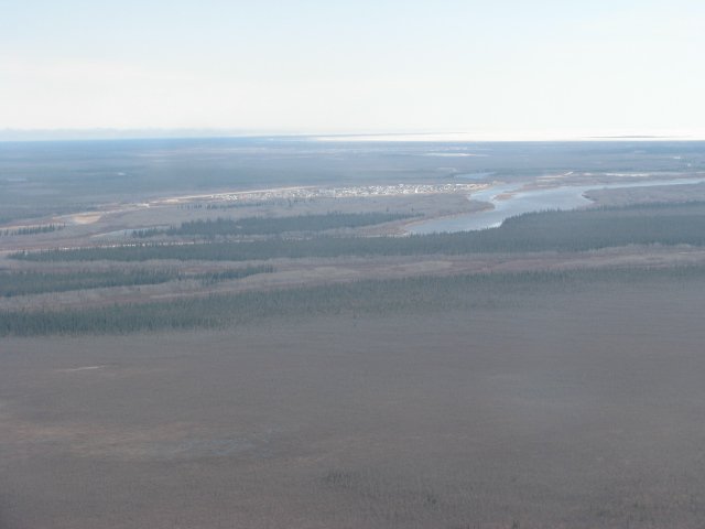
Attawapiskat, or Attawapiskat First Nation, is an isolated Cree First Nation located in Kenora District in northern Ontario, Canada, at the mouth of the Attawapiskat River near the west coast of James Bay. The First Nation controls the reserves at Attawapiskat 91 and Attawapiskat 91A, established upon the community's signing of Treaty 9 in 1930. The traditional territory of Attawapiskat extends beyond its current location up the James Bay coast to Hudson Bay and hundreds of kilometres inland along river tributaries.
The people of Attawapiskat maintain some knowledge of their ancestral Swampy Cree language and some still participate in subsistence living, hunting in the land around the reserves. However, Attawapiskat has access to modern amenities including telecommunications services and a hospital, as well as an elementary and high school. The community is connected to other towns along the shore of James Bay by the seasonal ice road constructed each December, linking it to Kashechewan, Fort Albany, and Moosonee. The now-closed Victor Diamond Mine is located close to the community.
Attawapiskat has received national media attention for several crises, including a crisis of inadequate and insufficient housing, a lack of clean drinking water, and a youth suicide crisis.
The name Attawapiskat is an anglicisation of the Swampy Cree phrase ê-tawâpiskâk (ᐁ ᑕᐙᐱᔅᑳᒃ), which means "it is open and rocky," as a description of the Attawapiskat River valley.
Another explanation by a community member gives the meaning of "Kattawapiskak Seepee" as "river between the rocks."
The people of Attawapiskat are Mushkegowuk, also known as Swampy Cree or Hudson Bay Lowland Cree. Local oral history and documentation in the archives of the Hudson's Bay Company attests that ancestors of the present-day inhabitants of Attawapiskat had occupied an area extending from the Kapiskau River in the south, to Cape Henrietta Maria (the point where the coasts of Hudson's Bay and James Bay meet) in the north, and from Akimiski Island in the east to Mississa Lake in the west. Across this vast range, family units came together to form smaller bands, which have been identified by anthropologists according to the river basins they tended to occupy. According to John J. Honigmann, these included the Sutton (or "Namee'ko") River people and the Winisk Indians inland of Cape Henrietta Maria, and then from north to south the Lake River, Opinikaw, Attawapiskat, Nawaacii (or "Lawaci"), and Kapiskaw bands. Honigmann identified these loosely defined bands as "Attawapiskat Indians" in his 1956 ethnographic study of the Indigenous people.
The site of the present settlement at the mouth of the Attawapiskat River (the reserve known as Attawapiskat 91A) has for centuries been a gathering place for the Mushkegowuk. Attawapiskat 91A was originally a seasonal camp that the Cree visited only in the spring and summer to take advantage of the bountiful fishing on a major river of James Bay. Historically, in the wintertime, families moved to more dispersed sites along the coast, inland or on Akimiski Island, where they trapped, hunted, and gathered roots, fruit and nuts. This way of life has persisted at least as recently as the 1950s, with family groups dispersing across the territory beginning in the autumn.
By 1693, a permanent trading post controlled by the British Hudson's Bay Company (HBC) had been established at Fort Albany, marking the beginning of prolonged contact between the people of the area and Europeans, part of the European colonization of the Americas. This contact introduced the commercial fur trapping economy to the area. People who would typically live inland moved closer to the coastal trade centre, laying the basis for the modern-day settlement at Attawapiskat 91A.
Hub AI
Attawapiskat First Nation AI simulator
(@Attawapiskat First Nation_simulator)
Attawapiskat First Nation
Attawapiskat, or Attawapiskat First Nation, is an isolated Cree First Nation located in Kenora District in northern Ontario, Canada, at the mouth of the Attawapiskat River near the west coast of James Bay. The First Nation controls the reserves at Attawapiskat 91 and Attawapiskat 91A, established upon the community's signing of Treaty 9 in 1930. The traditional territory of Attawapiskat extends beyond its current location up the James Bay coast to Hudson Bay and hundreds of kilometres inland along river tributaries.
The people of Attawapiskat maintain some knowledge of their ancestral Swampy Cree language and some still participate in subsistence living, hunting in the land around the reserves. However, Attawapiskat has access to modern amenities including telecommunications services and a hospital, as well as an elementary and high school. The community is connected to other towns along the shore of James Bay by the seasonal ice road constructed each December, linking it to Kashechewan, Fort Albany, and Moosonee. The now-closed Victor Diamond Mine is located close to the community.
Attawapiskat has received national media attention for several crises, including a crisis of inadequate and insufficient housing, a lack of clean drinking water, and a youth suicide crisis.
The name Attawapiskat is an anglicisation of the Swampy Cree phrase ê-tawâpiskâk (ᐁ ᑕᐙᐱᔅᑳᒃ), which means "it is open and rocky," as a description of the Attawapiskat River valley.
Another explanation by a community member gives the meaning of "Kattawapiskak Seepee" as "river between the rocks."
The people of Attawapiskat are Mushkegowuk, also known as Swampy Cree or Hudson Bay Lowland Cree. Local oral history and documentation in the archives of the Hudson's Bay Company attests that ancestors of the present-day inhabitants of Attawapiskat had occupied an area extending from the Kapiskau River in the south, to Cape Henrietta Maria (the point where the coasts of Hudson's Bay and James Bay meet) in the north, and from Akimiski Island in the east to Mississa Lake in the west. Across this vast range, family units came together to form smaller bands, which have been identified by anthropologists according to the river basins they tended to occupy. According to John J. Honigmann, these included the Sutton (or "Namee'ko") River people and the Winisk Indians inland of Cape Henrietta Maria, and then from north to south the Lake River, Opinikaw, Attawapiskat, Nawaacii (or "Lawaci"), and Kapiskaw bands. Honigmann identified these loosely defined bands as "Attawapiskat Indians" in his 1956 ethnographic study of the Indigenous people.
The site of the present settlement at the mouth of the Attawapiskat River (the reserve known as Attawapiskat 91A) has for centuries been a gathering place for the Mushkegowuk. Attawapiskat 91A was originally a seasonal camp that the Cree visited only in the spring and summer to take advantage of the bountiful fishing on a major river of James Bay. Historically, in the wintertime, families moved to more dispersed sites along the coast, inland or on Akimiski Island, where they trapped, hunted, and gathered roots, fruit and nuts. This way of life has persisted at least as recently as the 1950s, with family groups dispersing across the territory beginning in the autumn.
By 1693, a permanent trading post controlled by the British Hudson's Bay Company (HBC) had been established at Fort Albany, marking the beginning of prolonged contact between the people of the area and Europeans, part of the European colonization of the Americas. This contact introduced the commercial fur trapping economy to the area. People who would typically live inland moved closer to the coastal trade centre, laying the basis for the modern-day settlement at Attawapiskat 91A.
Recent media