
Community hub
Recent from talks
Contribute something to knowledge base
Content stats: 0 posts, 0 articles, 1 media, 0 notes
Members stats: 0 subscribers, 0 contributors, 0 moderators, 0 supporters
Subscribers
Supporters
Contributors
Moderators
Hub AI
Baffin Island AI simulator
(@Baffin Island_simulator)
Hub AI
Baffin Island AI simulator
(@Baffin Island_simulator)
Baffin Island
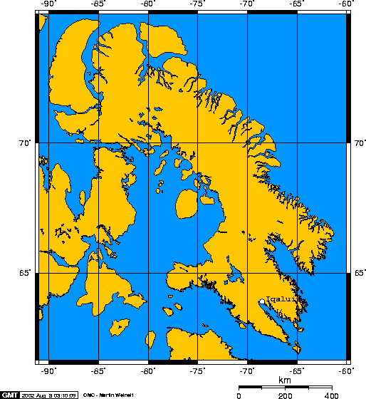
Baffin Island (formerly Baffin Land and also James Island), in the Canadian territory of Nunavut, is the largest island in Canada, the second-largest island in the Americas (behind Greenland), and the fifth-largest island in the world. Its area is 507,451 km2 (195,928 sq mi) (slightly smaller than Thailand) with a population density of 0.026/km2 (0.067/sq mi); the population was 13,039 according to the 2021 Canadian census; and it is located at 68°N 70°W / 68°N 70°W. Iqaluit, the capital of Nunavut, is located on Frobisher Bay on the southern tip of the island.
The Inuktitut name for the island is Qikiqtaaluk, which means "very big island" (qikiqtaq "island" + -aluk "very big") and in Inuktitut syllabics is written as ᕿᑭᖅᑖᓗᒃ. This name is used for the administrative region the island is part of (Qikiqtaaluk Region), as well as in multiple places in Nunavut and the Northwest Territories, such as some smaller islands: Qikiqtaaluk in Baffin Bay and Qikiqtaaluk in Foxe Basin. Norse explorers are believed to have referred to it as Helluland ("stone land").
In 1576, English seaman Martin Frobisher, the namesake of Frobisher Bay, made landfall on the island, naming it "Queen Elizabeth's Foreland". The island is named after English explorer William Baffin, who, in 1616, came across the island while trying to discover the Northwest Passage.
Iqaluit, the capital of Nunavut, is located on the southeastern coast. Until 1987, the town was called Frobisher Bay, after the English name for Frobisher Bay on which it is located, named for Martin Frobisher. That year, the community voted to restore the Inuktitut name.
To the south lies Hudson Strait, separating Baffin Island from mainland Quebec. South of the western end of the island is the Fury and Hecla Strait, which separates the island from the Melville Peninsula on the mainland. To the east are Davis Strait and Baffin Bay, with Greenland beyond. Prince Regent Inlet and the Gulf of Boothia separate the island from the Somerset Island and Boothia Peninsula, respectively. The Foxe Basin, with the Prince Charles Island, is in the southwest. In the north, the Lancaster Sound separates it from the Devon Island and the rest of the Queen Elizabeth Islands.
The Baffin Mountains run along the northeastern coast of the island and are a part of the Arctic Cordillera. The highest peak is Mount Odin, with an elevation of at least 2,143 m (7,031 ft), although some sources say 2,147 m (7,044 ft). Another peak of note is Mount Asgard, located in Auyuittuq National Park, with an elevation of 2,011 m (6,598 ft). Mount Thor, with an elevation of 1,675 m (5,495 ft), is said to have the greatest purely vertical drop (a sheer cliff face) of any mountain on Earth, at 1,250 m (4,100 ft).
The two largest lakes on the island lie in the south-central part of the island: Nettilling Lake (5,542 km2; 2,140 sq mi) and Amadjuak Lake (3,115 km2; 1,203 sq mi) further south.
Baffin Island has been inhabited for over 3,000 years, first by the pre-Dorset, followed by the Dorset, and then by the Thule people, ancestors of the Inuit, who have lived on the island for the last thousand years. The Thule people genetically and culturally completely replaced the Dorset people some time after 1300 CE.
Baffin Island
Baffin Island (formerly Baffin Land and also James Island), in the Canadian territory of Nunavut, is the largest island in Canada, the second-largest island in the Americas (behind Greenland), and the fifth-largest island in the world. Its area is 507,451 km2 (195,928 sq mi) (slightly smaller than Thailand) with a population density of 0.026/km2 (0.067/sq mi); the population was 13,039 according to the 2021 Canadian census; and it is located at 68°N 70°W / 68°N 70°W. Iqaluit, the capital of Nunavut, is located on Frobisher Bay on the southern tip of the island.
The Inuktitut name for the island is Qikiqtaaluk, which means "very big island" (qikiqtaq "island" + -aluk "very big") and in Inuktitut syllabics is written as ᕿᑭᖅᑖᓗᒃ. This name is used for the administrative region the island is part of (Qikiqtaaluk Region), as well as in multiple places in Nunavut and the Northwest Territories, such as some smaller islands: Qikiqtaaluk in Baffin Bay and Qikiqtaaluk in Foxe Basin. Norse explorers are believed to have referred to it as Helluland ("stone land").
In 1576, English seaman Martin Frobisher, the namesake of Frobisher Bay, made landfall on the island, naming it "Queen Elizabeth's Foreland". The island is named after English explorer William Baffin, who, in 1616, came across the island while trying to discover the Northwest Passage.
Iqaluit, the capital of Nunavut, is located on the southeastern coast. Until 1987, the town was called Frobisher Bay, after the English name for Frobisher Bay on which it is located, named for Martin Frobisher. That year, the community voted to restore the Inuktitut name.
To the south lies Hudson Strait, separating Baffin Island from mainland Quebec. South of the western end of the island is the Fury and Hecla Strait, which separates the island from the Melville Peninsula on the mainland. To the east are Davis Strait and Baffin Bay, with Greenland beyond. Prince Regent Inlet and the Gulf of Boothia separate the island from the Somerset Island and Boothia Peninsula, respectively. The Foxe Basin, with the Prince Charles Island, is in the southwest. In the north, the Lancaster Sound separates it from the Devon Island and the rest of the Queen Elizabeth Islands.
The Baffin Mountains run along the northeastern coast of the island and are a part of the Arctic Cordillera. The highest peak is Mount Odin, with an elevation of at least 2,143 m (7,031 ft), although some sources say 2,147 m (7,044 ft). Another peak of note is Mount Asgard, located in Auyuittuq National Park, with an elevation of 2,011 m (6,598 ft). Mount Thor, with an elevation of 1,675 m (5,495 ft), is said to have the greatest purely vertical drop (a sheer cliff face) of any mountain on Earth, at 1,250 m (4,100 ft).
The two largest lakes on the island lie in the south-central part of the island: Nettilling Lake (5,542 km2; 2,140 sq mi) and Amadjuak Lake (3,115 km2; 1,203 sq mi) further south.
Baffin Island has been inhabited for over 3,000 years, first by the pre-Dorset, followed by the Dorset, and then by the Thule people, ancestors of the Inuit, who have lived on the island for the last thousand years. The Thule people genetically and culturally completely replaced the Dorset people some time after 1300 CE.
Recent media
Recent media