
Community hub
Recent from talks
Contribute something
Nothing was collected or created yet.
Baihe County
View on WikipediaThis article needs additional citations for verification. (January 2021) |
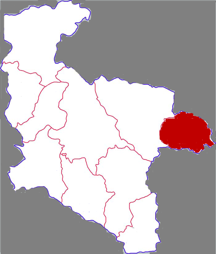
Baihe County (simplified Chinese: 白河县; traditional Chinese: 白河縣; pinyin: Báihé Xiàn; lit. 'white river') is located in the southeastern portion of Shaanxi province, China and is the easternmost county-level division under the jurisdiction of the prefecture-level city of Ankang. It is by the eastern part of the Daba Mountains and approaches the Han River on the north. On the east it borders Yun County (Hubei), on the south Zhushan County (Hubei), on the west Xunyang County, and is separated from Yunxi County (Hubei) by the Han River.[1] As of November 2020 the population was 162,774.[2]
Key Information

.png)
Baihe is in the north subtropical to warm temperate transitional climatic zone, and is part of the continental seasonal monsoon climate zone. The average temperature is 12.2 to 16.5 °C (54.0 to 61.7 °F), average yearly sunlight 1753.8 hours, average rainfall 787.5 mm (31.00 in), and has 234 to 261 frost-free days each year.
Baihe was historically nicknamed "The Head of Qin and the Tail of Wei." It is a largely rural county, populated mainly by Han Chinese.
Baihe's main outside transportation connections are the Xiangyu Railway, National Highway 316 and the Shiyan–Tianshui Expressway.
Administrative divisions
[edit]As of 2019, Baihe County is divided to 11 towns.[3]
- Towns
- Chengguan (城关镇)
- Zhongchang (中厂镇)
- Gouba (构扒镇)
- Kazi (卡子镇)
- Maoping (茅坪镇)
- Songjia (宋家镇)
- Xiying (西营镇)
- Cangshang (仓上镇)
- Lengshui (冷水镇)
- Shuangfeng (双丰镇)
- Mahu (麻虎镇)
Climate
[edit]| Climate data for Baihe, elevation 323 m (1,060 ft), (1991–2020 normals, extremes 1981–present) | |||||||||||||
|---|---|---|---|---|---|---|---|---|---|---|---|---|---|
| Month | Jan | Feb | Mar | Apr | May | Jun | Jul | Aug | Sep | Oct | Nov | Dec | Year |
| Record high °C (°F) | 19.8 (67.6) |
24.0 (75.2) |
36.3 (97.3) |
36.7 (98.1) |
37.9 (100.2) |
40.7 (105.3) |
42.1 (107.8) |
42.1 (107.8) |
41.2 (106.2) |
33.2 (91.8) |
27.4 (81.3) |
20.6 (69.1) |
42.1 (107.8) |
| Mean daily maximum °C (°F) | 8.8 (47.8) |
11.9 (53.4) |
17.5 (63.5) |
23.8 (74.8) |
27.6 (81.7) |
31.2 (88.2) |
33.3 (91.9) |
32.2 (90.0) |
27.0 (80.6) |
21.6 (70.9) |
15.8 (60.4) |
10.4 (50.7) |
21.8 (71.2) |
| Daily mean °C (°F) | 3.4 (38.1) |
6.1 (43.0) |
11.0 (51.8) |
16.6 (61.9) |
20.9 (69.6) |
24.8 (76.6) |
27.2 (81.0) |
26.3 (79.3) |
21.5 (70.7) |
16.0 (60.8) |
10.2 (50.4) |
5.0 (41.0) |
15.8 (60.4) |
| Mean daily minimum °C (°F) | −0.3 (31.5) |
2.0 (35.6) |
6.2 (43.2) |
11.3 (52.3) |
15.8 (60.4) |
19.9 (67.8) |
23.0 (73.4) |
22.4 (72.3) |
18.0 (64.4) |
12.6 (54.7) |
6.7 (44.1) |
1.4 (34.5) |
11.6 (52.9) |
| Record low °C (°F) | −6.8 (19.8) |
−6.3 (20.7) |
−3.0 (26.6) |
−0.1 (31.8) |
7.5 (45.5) |
13.6 (56.5) |
15.3 (59.5) |
14.5 (58.1) |
9.2 (48.6) |
1.0 (33.8) |
−2.8 (27.0) |
−11.6 (11.1) |
−11.6 (11.1) |
| Average precipitation mm (inches) | 12.7 (0.50) |
15.7 (0.62) |
37.6 (1.48) |
57.2 (2.25) |
81.4 (3.20) |
105.3 (4.15) |
122.9 (4.84) |
122.0 (4.80) |
102.8 (4.05) |
73.2 (2.88) |
32.4 (1.28) |
9.5 (0.37) |
772.7 (30.42) |
| Average precipitation days (≥ 0.1 mm) | 5.6 | 6.6 | 9.1 | 10.2 | 11.4 | 11.0 | 12.8 | 11.6 | 12.2 | 11.5 | 8.4 | 5.2 | 115.6 |
| Average snowy days | 4.3 | 3.3 | 1.4 | 0.1 | 0 | 0 | 0 | 0 | 0 | 0 | 0.7 | 1.9 | 11.7 |
| Average relative humidity (%) | 69 | 67 | 66 | 69 | 72 | 74 | 78 | 79 | 81 | 82 | 79 | 71 | 74 |
| Mean monthly sunshine hours | 116.9 | 109.0 | 142.6 | 165.3 | 172.9 | 176.8 | 195.8 | 180.4 | 122.9 | 115.8 | 111.5 | 119.5 | 1,729.4 |
| Percentage possible sunshine | 37 | 35 | 38 | 42 | 40 | 41 | 45 | 44 | 33 | 33 | 36 | 39 | 39 |
| Source: China Meteorological Administration[4][5] | |||||||||||||
Culture
[edit]References
[edit]- ^ "白河概览-白河县人民政府". www.baihe.gov.cn. Retrieved 2022-02-14.
- ^ "第七次全国人口普查公报(第六号)-白河县人民政府". www.baihe.gov.cn. Retrieved 2022-02-14.
- ^ "统计用区划代码" (in Chinese). XZQH. Retrieved 2021-01-02.
- ^ 中国气象数据网 – WeatherBk Data (in Simplified Chinese). China Meteorological Administration. Retrieved 26 August 2023.
- ^ 中国气象数据网 (in Simplified Chinese). China Meteorological Administration. Retrieved 26 August 2023.
- ^ "白河县鹬蚌舞_白河县民间艺术_三秦游网". www.sanqinyou.com. Retrieved 2022-02-14.
- ^ "白河县概况". m.cyw.com. Retrieved 2022-02-14.
32°42′51″N 109°55′16″E / 32.71417°N 109.92111°E
| International | |
|---|---|
| National | |