Community hub
Recent from talks
Knowledge base stats:
Talk channels stats:
Members stats:
Admiralty Islands campaign
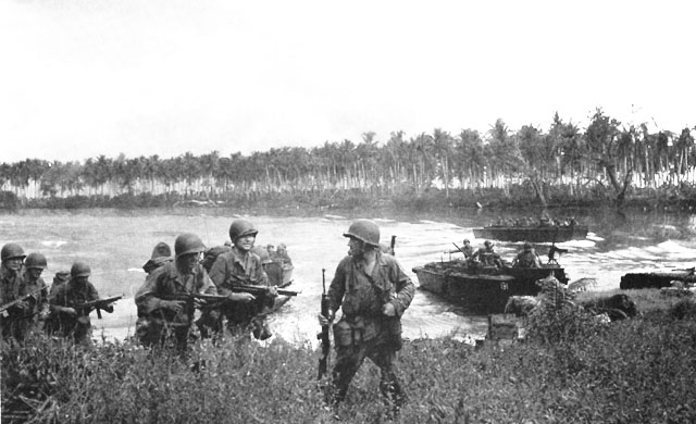
The Admiralty Islands campaign (Operation Brewer) was a series of battles in the New Guinea campaign of World War II in which the United States Army's 1st Cavalry Division took the Japanese-held Admiralty Islands.
Acting on reports from airmen that there were no signs of enemy activity and the islands might have been evacuated, General Douglas MacArthur accelerated his timetable for capturing the Admiralties and ordered an immediate reconnaissance in force. The campaign began on 29 February 1944 when a force landed on Los Negros, the third-largest island in the group. By using a small, isolated beach where the Japanese had not anticipated an assault, the force achieved tactical surprise, but the islands proved to be far from unoccupied. A furious battle over the islands ensued.
In the end, air superiority and command of the sea allowed the Allies to heavily reinforce their position on Los Negros. The 1st Cavalry Division could then overrun the islands. The campaign officially ended on 18 May 1944. The Allied victory completed the isolation of the major Japanese base at Rabaul that was the ultimate objective of the Allied campaigns of 1942 and 1943. A major air and naval base was developed in the Admiralty Islands that became an important launching point for the campaigns of 1944 in the Pacific. This campaign marked the end of MacArthur's Operation Cartwheel, which was a multi-theater operation conducted to turn the powerful Japanese base of Rabaul into a de facto prisoner-of-war camp.
The Admiralty Islands lie 200 miles (320 km) north east of the mainland of New Guinea and 360 miles (580 km) west of Rabaul, only two degrees south of the equator. The climate is tropical, with constant high temperatures and high humidity and an annual rainfall of 154 inches (3,900 mm). Thunderstorms are common. December to May is the north west monsoon season, with prevailing winds from that direction.
The largest island in the group is Manus Island, which is about 49 miles (79 km) across from east to west and 16 miles (26 km) wide from north to south. The interior is mountainous, with peaks rising to 3,000 feet (910 m) and largely covered with thick tropical rainforest. The largely uncharted coastline had numerous reefs. The shoreline consisted mostly of mangrove swamp.
The third largest island in the province, Los Negros lies to the northeast of Manus, from which it is separated by the narrow Loniu Passage. The island contains two important harbours of its own, Papitalai on the west coast, which connects with Seeadler Harbour, and Hyane on the east coast. The two are separated by a 50-yard (46 m) wide sandy spit. Here, the natives built a skidway over which they could drag canoes between the two harbours. Los Negros curves horseshoe-like, forming a natural breakwater for Seeadler Harbour, the remainder of which is enclosed by Manus and a series of smaller islands. The main entrance was through a 1.5-mile (2.4 km) wide passage between Hauwei and Ndrilo Islands. Seeadler Harbour is about 20 miles (32 km) across from east to west and 6 miles (9.7 km) wide from north to south, and up to 120 feet (37 m) deep.
In July 1942, the Joint Chiefs of Staff approved a series of operations against the Japanese bastion at Rabaul, which blocked any Allied advance along the northern coast of New Guinea towards the Philippines or northward towards the main Japanese naval base at Truk. In keeping with the overall Allied grand strategy of Europe first, the immediate aim of these operations was not the defeat of Japan but merely the reduction of the threat posed by Japanese aircraft and warships based at Rabaul to air and sea communications between the United States and Australia. By agreement among the Allied nations, in March 1942 the Pacific theatre was divided into the South West Pacific Area, under General Douglas MacArthur, and the Pacific Ocean Areas, under Admiral Chester W. Nimitz. Rabaul fell within MacArthur's area but the initial operations in the southern Solomon Islands came under Nimitz. The Japanese reaction was more violent than anticipated and some months passed before the Guadalcanal Campaign was brought to a successful conclusion. Meanwhile, General MacArthur's forces—primarily Australian—fought off a series of Japanese offensives in Papua in the Kokoda Track Campaign, Battle of Milne Bay, Battle of Buna-Gona, and the Battle of Wau.
At the Pacific Military Conference in March 1943, the Joint Chiefs of Staff approved the latest version of General MacArthur's Elkton plan for an advance on Rabaul. Owing to a shortage of resources, particularly heavy bomber aircraft, the final stage of the plan, the capture of Rabaul itself, was postponed until 1944. By July 1943, the Joint Chiefs were considering the possibility of neutralising and bypassing Rabaul, but the navy would still need a forward fleet base. The Admiralty Islands, already a part of the Elkton plan, could serve this purpose, as they contained flat areas for airstrips, space for military installations, and Seeadler Harbour, which was large enough to accommodate a naval task force. On 6 August 1943, the Joint Chiefs of Staff adopted a plan that called for the neutralisation rather than the capture of Rabaul, and scheduled the invasion of the Admiralty Islands for 1 June 1944.
Hub AI
Admiralty Islands campaign AI simulator
(@Admiralty Islands campaign_simulator)
Admiralty Islands campaign
The Admiralty Islands campaign (Operation Brewer) was a series of battles in the New Guinea campaign of World War II in which the United States Army's 1st Cavalry Division took the Japanese-held Admiralty Islands.
Acting on reports from airmen that there were no signs of enemy activity and the islands might have been evacuated, General Douglas MacArthur accelerated his timetable for capturing the Admiralties and ordered an immediate reconnaissance in force. The campaign began on 29 February 1944 when a force landed on Los Negros, the third-largest island in the group. By using a small, isolated beach where the Japanese had not anticipated an assault, the force achieved tactical surprise, but the islands proved to be far from unoccupied. A furious battle over the islands ensued.
In the end, air superiority and command of the sea allowed the Allies to heavily reinforce their position on Los Negros. The 1st Cavalry Division could then overrun the islands. The campaign officially ended on 18 May 1944. The Allied victory completed the isolation of the major Japanese base at Rabaul that was the ultimate objective of the Allied campaigns of 1942 and 1943. A major air and naval base was developed in the Admiralty Islands that became an important launching point for the campaigns of 1944 in the Pacific. This campaign marked the end of MacArthur's Operation Cartwheel, which was a multi-theater operation conducted to turn the powerful Japanese base of Rabaul into a de facto prisoner-of-war camp.
The Admiralty Islands lie 200 miles (320 km) north east of the mainland of New Guinea and 360 miles (580 km) west of Rabaul, only two degrees south of the equator. The climate is tropical, with constant high temperatures and high humidity and an annual rainfall of 154 inches (3,900 mm). Thunderstorms are common. December to May is the north west monsoon season, with prevailing winds from that direction.
The largest island in the group is Manus Island, which is about 49 miles (79 km) across from east to west and 16 miles (26 km) wide from north to south. The interior is mountainous, with peaks rising to 3,000 feet (910 m) and largely covered with thick tropical rainforest. The largely uncharted coastline had numerous reefs. The shoreline consisted mostly of mangrove swamp.
The third largest island in the province, Los Negros lies to the northeast of Manus, from which it is separated by the narrow Loniu Passage. The island contains two important harbours of its own, Papitalai on the west coast, which connects with Seeadler Harbour, and Hyane on the east coast. The two are separated by a 50-yard (46 m) wide sandy spit. Here, the natives built a skidway over which they could drag canoes between the two harbours. Los Negros curves horseshoe-like, forming a natural breakwater for Seeadler Harbour, the remainder of which is enclosed by Manus and a series of smaller islands. The main entrance was through a 1.5-mile (2.4 km) wide passage between Hauwei and Ndrilo Islands. Seeadler Harbour is about 20 miles (32 km) across from east to west and 6 miles (9.7 km) wide from north to south, and up to 120 feet (37 m) deep.
In July 1942, the Joint Chiefs of Staff approved a series of operations against the Japanese bastion at Rabaul, which blocked any Allied advance along the northern coast of New Guinea towards the Philippines or northward towards the main Japanese naval base at Truk. In keeping with the overall Allied grand strategy of Europe first, the immediate aim of these operations was not the defeat of Japan but merely the reduction of the threat posed by Japanese aircraft and warships based at Rabaul to air and sea communications between the United States and Australia. By agreement among the Allied nations, in March 1942 the Pacific theatre was divided into the South West Pacific Area, under General Douglas MacArthur, and the Pacific Ocean Areas, under Admiral Chester W. Nimitz. Rabaul fell within MacArthur's area but the initial operations in the southern Solomon Islands came under Nimitz. The Japanese reaction was more violent than anticipated and some months passed before the Guadalcanal Campaign was brought to a successful conclusion. Meanwhile, General MacArthur's forces—primarily Australian—fought off a series of Japanese offensives in Papua in the Kokoda Track Campaign, Battle of Milne Bay, Battle of Buna-Gona, and the Battle of Wau.
At the Pacific Military Conference in March 1943, the Joint Chiefs of Staff approved the latest version of General MacArthur's Elkton plan for an advance on Rabaul. Owing to a shortage of resources, particularly heavy bomber aircraft, the final stage of the plan, the capture of Rabaul itself, was postponed until 1944. By July 1943, the Joint Chiefs were considering the possibility of neutralising and bypassing Rabaul, but the navy would still need a forward fleet base. The Admiralty Islands, already a part of the Elkton plan, could serve this purpose, as they contained flat areas for airstrips, space for military installations, and Seeadler Harbour, which was large enough to accommodate a naval task force. On 6 August 1943, the Joint Chiefs of Staff adopted a plan that called for the neutralisation rather than the capture of Rabaul, and scheduled the invasion of the Admiralty Islands for 1 June 1944.