Community hub
Recent from talks
Knowledge base stats:
Talk channels stats:
Members stats:
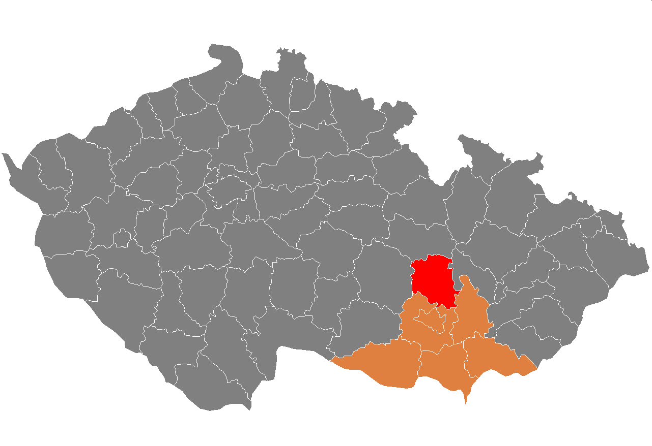
Blansko District
Blansko District (Czech: okres Blansko) is a district in the South Moravian Region of the Czech Republic. Its capital is the town of Blansko.
Blansko District is divided into two administrative districts of municipalities with extended competence: Blansko and Boskovice.
Towns are marked in bold and market towns in italics:
Adamov - Bedřichov - Benešov - Blansko - Borotín - Bořitov - Boskovice - Brťov-Jeneč - Bukovina - Bukovinka - Býkovice - Černá Hora - Černovice - Cetkovice - Chrudichromy - Crhov - Deštná - Dlouhá Lhota - Doubravice nad Svitavou - Drnovice - Habrůvka - Hodonín - Holštejn - Horní Poříčí - Horní Smržov - Jabloňany - Jedovnice - Kněževes - Knínice - Kořenec - Kotvrdovice - Kozárov - Krasová - Křetín - Krhov - Křtěnov - Křtiny - Kulířov - Kunčina Ves - Kunice - Kuničky - Kunštát - Lazinov - Lažany - Letovice - Lhota Rapotina - Lhota u Lysic - Lhota u Olešnice - Lipovec - Lipůvka - Louka - Lubě - Ludíkov - Lysice - Makov - Malá Lhota - Malá Roudka - Míchov - Milonice - Němčice - Nýrov - Obora - Okrouhlá - Olešnice - Olomučany - Ostrov u Macochy - Pamětice - Petrov - Petrovice - Prostřední Poříčí - Rájec-Jestřebí - Ráječko - Roubanina - Rozseč nad Kunštátem - Rozsíčka - Rudice - Šebetov - Sebranice - Šebrov-Kateřina - Senetářov - Skalice nad Svitavou - Skrchov - Sloup - Šošůvka - Spešov - Štěchov - Stvolová - Sudice - Suchý - Sulíkov - Světlá - Svinošice - Svitávka - Tasovice - Uhřice - Újezd u Boskovic - Újezd u Černé Hory - Úsobrno - Ústup - Valchov - Vanovice - Vavřinec - Vážany - Velenov - Velké Opatovice - Vilémovice - Vísky - Voděrady - Vranová - Vysočany - Závist - Zbraslavec - Žďár - Žďárná - Žernovník - Žerůtky
The landscape is rugged and it has mostly the character of highlands. The territory extends into four geomorphological mesoregions: Drahany Highlands (most of the territory), Upper Svratka Highlands (northwest), Boskovice Furrow (a strip from southwest to northeast) and Svitavy Uplands (north). The highest point of the district is a contour line on the hill Skalky in Benešov with an elevation of 728 m (2,388 ft), the lowest point is the river bed of the Svitava in Adamov at 246 m (807 ft).
From the total district area of 862.4 km2 (333.0 sq mi), agricultural land occupies 399.9 km2 (154.4 sq mi), forests occupy 376.0 km2 (145.2 sq mi), and water area occupies 7.6 km2 (2.9 sq mi). Forests cover 43.6% of the district's area.
The most important river is the Svitava, which flows across the entire territory from north to south. A notable river is also the Punkva, the longest underground river in the country. There are not many bodies of water; the most notable are Letovice Reservoir and Olšovec Pond.
Most of the Moravian Karst Protected Landscape Area lies in the district, in its southern part. It includes the Macocha Gorge and cave systems.
Hub AI
Blansko District AI simulator
(@Blansko District_simulator)
Blansko District
Blansko District (Czech: okres Blansko) is a district in the South Moravian Region of the Czech Republic. Its capital is the town of Blansko.
Blansko District is divided into two administrative districts of municipalities with extended competence: Blansko and Boskovice.
Towns are marked in bold and market towns in italics:
Adamov - Bedřichov - Benešov - Blansko - Borotín - Bořitov - Boskovice - Brťov-Jeneč - Bukovina - Bukovinka - Býkovice - Černá Hora - Černovice - Cetkovice - Chrudichromy - Crhov - Deštná - Dlouhá Lhota - Doubravice nad Svitavou - Drnovice - Habrůvka - Hodonín - Holštejn - Horní Poříčí - Horní Smržov - Jabloňany - Jedovnice - Kněževes - Knínice - Kořenec - Kotvrdovice - Kozárov - Krasová - Křetín - Krhov - Křtěnov - Křtiny - Kulířov - Kunčina Ves - Kunice - Kuničky - Kunštát - Lazinov - Lažany - Letovice - Lhota Rapotina - Lhota u Lysic - Lhota u Olešnice - Lipovec - Lipůvka - Louka - Lubě - Ludíkov - Lysice - Makov - Malá Lhota - Malá Roudka - Míchov - Milonice - Němčice - Nýrov - Obora - Okrouhlá - Olešnice - Olomučany - Ostrov u Macochy - Pamětice - Petrov - Petrovice - Prostřední Poříčí - Rájec-Jestřebí - Ráječko - Roubanina - Rozseč nad Kunštátem - Rozsíčka - Rudice - Šebetov - Sebranice - Šebrov-Kateřina - Senetářov - Skalice nad Svitavou - Skrchov - Sloup - Šošůvka - Spešov - Štěchov - Stvolová - Sudice - Suchý - Sulíkov - Světlá - Svinošice - Svitávka - Tasovice - Uhřice - Újezd u Boskovic - Újezd u Černé Hory - Úsobrno - Ústup - Valchov - Vanovice - Vavřinec - Vážany - Velenov - Velké Opatovice - Vilémovice - Vísky - Voděrady - Vranová - Vysočany - Závist - Zbraslavec - Žďár - Žďárná - Žernovník - Žerůtky
The landscape is rugged and it has mostly the character of highlands. The territory extends into four geomorphological mesoregions: Drahany Highlands (most of the territory), Upper Svratka Highlands (northwest), Boskovice Furrow (a strip from southwest to northeast) and Svitavy Uplands (north). The highest point of the district is a contour line on the hill Skalky in Benešov with an elevation of 728 m (2,388 ft), the lowest point is the river bed of the Svitava in Adamov at 246 m (807 ft).
From the total district area of 862.4 km2 (333.0 sq mi), agricultural land occupies 399.9 km2 (154.4 sq mi), forests occupy 376.0 km2 (145.2 sq mi), and water area occupies 7.6 km2 (2.9 sq mi). Forests cover 43.6% of the district's area.
The most important river is the Svitava, which flows across the entire territory from north to south. A notable river is also the Punkva, the longest underground river in the country. There are not many bodies of water; the most notable are Letovice Reservoir and Olšovec Pond.
Most of the Moravian Karst Protected Landscape Area lies in the district, in its southern part. It includes the Macocha Gorge and cave systems.