Community hub
Recent from talks
Knowledge base stats:
Talk channels stats:
Members stats:
Blyth Navigation
The Blyth Navigation was a canal in Suffolk, England, running 7 miles (11 km) from Halesworth to the North Sea at Southwold. It opened in 1761, and was insolvent by 1884. Its demise was accelerated by an attempt to reclaim saltings at Blythburgh, which resulted in the estuary silting up. It was used sporadically until 1911, and was not formally abandoned until 1934.
Between Southwold and Walberswick, the mouth of the River Blyth forms a tidal creek, which opens out into a large area of saltings below the first bridge over the river at Blythburgh. The river was navigable to the port of Blythburgh until the 16th century, but navigation was increasingly affected by silting up of the channel. The volume of water which drained from the saltings on every tide kept the mouth of the river scoured, and enabled Southwold to develop as an important, though minor, port.
The idea of making the river navigable beyond Blythburgh was proposed by Thomas Knights in the 1740s. Knights was a brewer from Halesworth, and suggested that Southwold harbour needed to be improved first. An act of Parliament, the Southwold Harbour Act 1746 (20 Geo. 2. c. 14), was obtained to authorise the improvements, which were sufficiently successful that harbour dues more than doubled over the next five years. Knights tried to gain more support for a navigation to Halesworth, and a plan for the navigation, including a branch from Halesworth to Ubbeston was prepared by Benjamin Reeve in 1753. The project which included three locks was costed at £4,614 by John Reynolds in May 1753, but there was a delay before the bill was submitted to Parliament.
Following the granting of the River Blyth Navigation Act 1757 (30 Geo. 2. c. 47) on 1 April 1757, which included additional powers for the Southwold Harbour trustees, a new survey was carried out by Langley Edwards, who estimated the cost at £3,000, which included the purchase of Wenhaston watermill. By 1759, subscriptions had been received from 38 people, mainly from the immediate locality, for a total of £3,600. Having made the estimate, Edwards was responsible for completing the work to that price, but failed to attend most of the meetings which the commissioners called. Despite his elusiveness, the work was completed at a cost of £3,822, and the official opening took place on 23 July 1761.
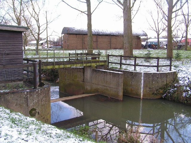
As built, the navigation had four locks while some sources also mention a tidal staunch located above Blythburgh bridge. Southwold Museum show two sections where the winding river channel was bypassed by a new straighter cut, one above Blythburgh bridge and one below, with several minor cuts to remove meanders. They place the tidal staunch just below Blyford bridge, and only show three further locks between there and Halesworth. Their map is based on surveys carried out in 1821 and 1840. Ordnance Survey maps show a lock around 600 yards (550 m) below Blyford bridge, which prevents tides from passing further upstream, a second just above Blyford bridge, a third just upstream of Wenhaston railway bridge, allowing the navigation to bypass Wenhaston corn mill, and a fourth at the start of the New Reach in Halesworth. Earlier 6-inch maps show an additional lock at Mells Bridge, then called Old Chapel Bridge.
From the sea, the navigation followed the River Blyth until it reached the Town River, which it followed to Halesworth Lock. From there, the New Reach took the canal to a wharf at Halesworth, which formed the terminus of the canal. The New Reach joined back up with the Town River a little further to the west, in order to provide the water supply for the locks. The locks were built to allow wherries to use the navigation, and so were 50 by 14 feet (15.2 by 4.3 m). However, they were unusual, in that the side walls curved outwards in the centre, to provide an extra 1.5 feet (0.46 m) of width. So that wherries could reach his maltings, a local maltster named Patrick Stead increased the water levels above the point where the New Reach and the Town River joined, by building an additional lock near the junction.
The day-to-day running of the navigation for the first four years was the responsibility of Samuel Jones, who appears to have overseen the construction of the navigation while Langley Edwards was elsewhere, and who was appointed as lock keeper, toll collector, warehouse keeper and surveyor of works by the commissioners. Each time his contract was to be renewed, they attempted to reduce his salary, and so he left and was replaced by his assistant William Bickers. Tolls over the next thirty years averaged £134 per year
In the early 19th century, the saltings below Blythburgh Bridge were reclaimed by the construction of embankments, to prevent them flooding. The plan was poorly thought out, and soon afterwards the condition of Southwold harbour was deteriorating, largely due to the deposition of silt, which made access difficult. The canal engineer John Rennie was asked to advise on a course of action, but although his report of 6 January 1820 pointed to the embanking of the saltings as the cause of the problem, he could offer no acceptable solution. The entrance to the harbour became blocked in 1839, and a further report was prepared by John Wright and James Walker in 1840. They calculated that the embankments surrounding the saltings excluded 5.5 million cubic yards (4.2 million m3) of tidal water on each tide, and thus the scouring effect of the river was considerably reduced.
Hub AI
Blyth Navigation AI simulator
(@Blyth Navigation_simulator)
Blyth Navigation
The Blyth Navigation was a canal in Suffolk, England, running 7 miles (11 km) from Halesworth to the North Sea at Southwold. It opened in 1761, and was insolvent by 1884. Its demise was accelerated by an attempt to reclaim saltings at Blythburgh, which resulted in the estuary silting up. It was used sporadically until 1911, and was not formally abandoned until 1934.
Between Southwold and Walberswick, the mouth of the River Blyth forms a tidal creek, which opens out into a large area of saltings below the first bridge over the river at Blythburgh. The river was navigable to the port of Blythburgh until the 16th century, but navigation was increasingly affected by silting up of the channel. The volume of water which drained from the saltings on every tide kept the mouth of the river scoured, and enabled Southwold to develop as an important, though minor, port.
The idea of making the river navigable beyond Blythburgh was proposed by Thomas Knights in the 1740s. Knights was a brewer from Halesworth, and suggested that Southwold harbour needed to be improved first. An act of Parliament, the Southwold Harbour Act 1746 (20 Geo. 2. c. 14), was obtained to authorise the improvements, which were sufficiently successful that harbour dues more than doubled over the next five years. Knights tried to gain more support for a navigation to Halesworth, and a plan for the navigation, including a branch from Halesworth to Ubbeston was prepared by Benjamin Reeve in 1753. The project which included three locks was costed at £4,614 by John Reynolds in May 1753, but there was a delay before the bill was submitted to Parliament.
Following the granting of the River Blyth Navigation Act 1757 (30 Geo. 2. c. 47) on 1 April 1757, which included additional powers for the Southwold Harbour trustees, a new survey was carried out by Langley Edwards, who estimated the cost at £3,000, which included the purchase of Wenhaston watermill. By 1759, subscriptions had been received from 38 people, mainly from the immediate locality, for a total of £3,600. Having made the estimate, Edwards was responsible for completing the work to that price, but failed to attend most of the meetings which the commissioners called. Despite his elusiveness, the work was completed at a cost of £3,822, and the official opening took place on 23 July 1761.
As built, the navigation had four locks while some sources also mention a tidal staunch located above Blythburgh bridge. Southwold Museum show two sections where the winding river channel was bypassed by a new straighter cut, one above Blythburgh bridge and one below, with several minor cuts to remove meanders. They place the tidal staunch just below Blyford bridge, and only show three further locks between there and Halesworth. Their map is based on surveys carried out in 1821 and 1840. Ordnance Survey maps show a lock around 600 yards (550 m) below Blyford bridge, which prevents tides from passing further upstream, a second just above Blyford bridge, a third just upstream of Wenhaston railway bridge, allowing the navigation to bypass Wenhaston corn mill, and a fourth at the start of the New Reach in Halesworth. Earlier 6-inch maps show an additional lock at Mells Bridge, then called Old Chapel Bridge.
From the sea, the navigation followed the River Blyth until it reached the Town River, which it followed to Halesworth Lock. From there, the New Reach took the canal to a wharf at Halesworth, which formed the terminus of the canal. The New Reach joined back up with the Town River a little further to the west, in order to provide the water supply for the locks. The locks were built to allow wherries to use the navigation, and so were 50 by 14 feet (15.2 by 4.3 m). However, they were unusual, in that the side walls curved outwards in the centre, to provide an extra 1.5 feet (0.46 m) of width. So that wherries could reach his maltings, a local maltster named Patrick Stead increased the water levels above the point where the New Reach and the Town River joined, by building an additional lock near the junction.
The day-to-day running of the navigation for the first four years was the responsibility of Samuel Jones, who appears to have overseen the construction of the navigation while Langley Edwards was elsewhere, and who was appointed as lock keeper, toll collector, warehouse keeper and surveyor of works by the commissioners. Each time his contract was to be renewed, they attempted to reduce his salary, and so he left and was replaced by his assistant William Bickers. Tolls over the next thirty years averaged £134 per year
In the early 19th century, the saltings below Blythburgh Bridge were reclaimed by the construction of embankments, to prevent them flooding. The plan was poorly thought out, and soon afterwards the condition of Southwold harbour was deteriorating, largely due to the deposition of silt, which made access difficult. The canal engineer John Rennie was asked to advise on a course of action, but although his report of 6 January 1820 pointed to the embanking of the saltings as the cause of the problem, he could offer no acceptable solution. The entrance to the harbour became blocked in 1839, and a further report was prepared by John Wright and James Walker in 1840. They calculated that the embankments surrounding the saltings excluded 5.5 million cubic yards (4.2 million m3) of tidal water on each tide, and thus the scouring effect of the river was considerably reduced.