Recent from talks
California Coast Ranges
Knowledge base stats:
Talk channels stats:
Members stats:
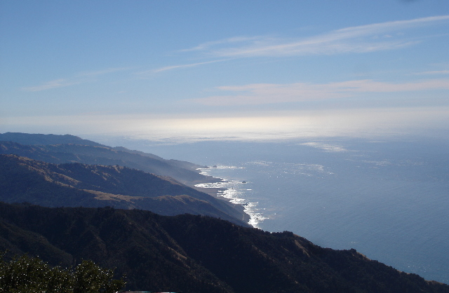
California Coast Ranges
The Coast Ranges of California span 400 miles (644 km) from Del Norte or Humboldt County, California, south to Santa Barbara County. The other three coastal California mountain ranges are the Transverse Ranges, Peninsular Ranges and the Klamath Mountains.
Physiographically, they are a section of the larger Pacific Border province, which in turn is part of the larger Pacific Mountain System physiographic division. UNESCO has included the "California Coast Ranges Biosphere Reserve" in its Man and the Biosphere Programme of World Network of Biosphere Reserves since 1983.
The northern end of the California Coast Ranges overlap the southern end of the Klamath Mountains for approximately 80 miles (130 km) on the west. They extend southward for more than 60 miles (97 km) to where the coastline turns eastward along the Santa Barbara Channel, around the area of Point Conception. Here the southern end meets the Los Angeles Transverse Ranges, or Sierras de los Angeles. The rocks themselves that comprise the mountains are of a great variety and widely varying geologic ages. Most of the rocks were formed during the Tertiary, Cretaceous and Jurassic periods. Most were deposited on the sea bottom as sediments, but in many places also had cracks, crevices and other gaps infused with molten lava or other masses of igneous rock, which were forced in molten condition into the sedimentary rocks. All of the range has been folded and faulted during several periods, with erosion of the softer rock giving much of the current appearance.[citation needed]
The California Ranges had a high production of mercury following the discovery of gold in the Sierra Nevada. In the Cache Creek Basin, Cenozoic cinnabar deposits near Clear Lake are the northernmost of a group of similar deposits associated with volcanism and migration of a transform fault system. During 1877, these deposits hit their peak production of mercury, producing approximately 2,776 metric tons (3,060 short tons). These abandoned mines are still a source of mine waste runoff in Cache Creek and other downstream bodies of water.
The Northern Coast Ranges are a section of the California Coast Ranges. They run parallel to the Pacific Coast from the North San Francisco Bay Area to coastal Del Norte County. The Klamath Mountains, including the Siskiyou Mountains sub-range, lie to the north and northeast. The Southern Coast Ranges lie to the south.
The Northern Coast Ranges run north–south parallel to the coast. Component ranges within the Northern Coast Ranges include the Mendocino Range of western Mendocino County and the Mayacamas, Sonoma, and Vaca Mountains and the Marin Hills of the North Bay.
They also include the King Range, which meet the sea in the "Lost Coast" region. The southernmost peak of the Northern Coast Ranges is Mount Tamalpais.
The highest point in the Northern Coast Ranges is Mount Linn, at 8,098 ft. (2,468 m).
Hub AI
California Coast Ranges AI simulator
(@California Coast Ranges_simulator)
California Coast Ranges
The Coast Ranges of California span 400 miles (644 km) from Del Norte or Humboldt County, California, south to Santa Barbara County. The other three coastal California mountain ranges are the Transverse Ranges, Peninsular Ranges and the Klamath Mountains.
Physiographically, they are a section of the larger Pacific Border province, which in turn is part of the larger Pacific Mountain System physiographic division. UNESCO has included the "California Coast Ranges Biosphere Reserve" in its Man and the Biosphere Programme of World Network of Biosphere Reserves since 1983.
The northern end of the California Coast Ranges overlap the southern end of the Klamath Mountains for approximately 80 miles (130 km) on the west. They extend southward for more than 60 miles (97 km) to where the coastline turns eastward along the Santa Barbara Channel, around the area of Point Conception. Here the southern end meets the Los Angeles Transverse Ranges, or Sierras de los Angeles. The rocks themselves that comprise the mountains are of a great variety and widely varying geologic ages. Most of the rocks were formed during the Tertiary, Cretaceous and Jurassic periods. Most were deposited on the sea bottom as sediments, but in many places also had cracks, crevices and other gaps infused with molten lava or other masses of igneous rock, which were forced in molten condition into the sedimentary rocks. All of the range has been folded and faulted during several periods, with erosion of the softer rock giving much of the current appearance.[citation needed]
The California Ranges had a high production of mercury following the discovery of gold in the Sierra Nevada. In the Cache Creek Basin, Cenozoic cinnabar deposits near Clear Lake are the northernmost of a group of similar deposits associated with volcanism and migration of a transform fault system. During 1877, these deposits hit their peak production of mercury, producing approximately 2,776 metric tons (3,060 short tons). These abandoned mines are still a source of mine waste runoff in Cache Creek and other downstream bodies of water.
The Northern Coast Ranges are a section of the California Coast Ranges. They run parallel to the Pacific Coast from the North San Francisco Bay Area to coastal Del Norte County. The Klamath Mountains, including the Siskiyou Mountains sub-range, lie to the north and northeast. The Southern Coast Ranges lie to the south.
The Northern Coast Ranges run north–south parallel to the coast. Component ranges within the Northern Coast Ranges include the Mendocino Range of western Mendocino County and the Mayacamas, Sonoma, and Vaca Mountains and the Marin Hills of the North Bay.
They also include the King Range, which meet the sea in the "Lost Coast" region. The southernmost peak of the Northern Coast Ranges is Mount Tamalpais.
The highest point in the Northern Coast Ranges is Mount Linn, at 8,098 ft. (2,468 m).
Recent media