Recent from talks
Cape Barren Island
Knowledge base stats:
Talk channels stats:
Members stats:
Cape Barren Island
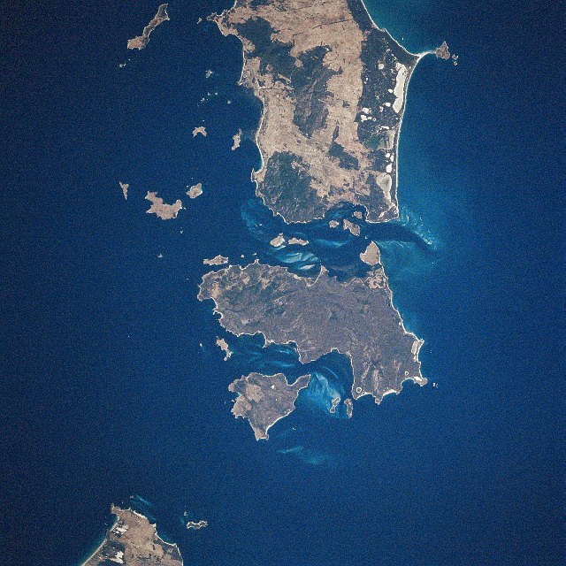
Cape Barren Island, officially truwana / Cape Barren Island, is a 478-square-kilometre (185 sq mi) island in Bass Strait, off the north-east coast of Tasmania, Australia. It is the second-largest island of the Furneaux Group, with the larger Flinders Island to the north, and the smaller Clarke Island to the south. The highest point on the island is Mount Munro at 715 metres (2,346 ft). Mount Munro is named after James Munro (c. 1779-1845), a former convict turned sealer who, from the 1820s, lived for more than 20 years with various indigenous women on nearby Preservation Island.
The south-eastern point of the island was named Cape Barren by Tobias Furneaux in HMS Adventure in March 1773.
The island was gazetted as a locality of the Flinders Council in 1968. Its population numbered 66 in 2016, most of them in the settlement called The Corner, on the north-west coast.
Australia's only native goose, the Cape Barren goose, was first documented by European explorers on the island.[citation needed]
Sealing is known to have taken place from 1798 when the 80-ton brig Nautilus, under Captain Charles Bishop, arrived from Sydney to commence commercial sealing in Bass Strait. Operations began in Kent’s Bay and nearly 9000 seal skins were taken in the first season. Other vessels followed from Sydney and the United States. Competition between the sealing gangs led to a violent clash between American and British sealers in 1803.
Today, the residents of Cape Barren Island consist of an Aboriginal community of approximately 70 people. Most of the residents are descended from people of mixed European and Aboriginal descent, who had originally settled on several smaller nearby islands but relocated to Cape Barren Island in the late 1870s. The colonial government of Tasmania established a formal reserve in 1881 and commenced providing basic social services to the community. By 1908, the population had grown to 250 people.
More active intervention by the Tasmanian government began in 1912, with the passage of the Cape Barren Act. The stated purpose of the act was to encourage the community to become self-sufficient through both incentives and disincentives. Government visitors throughout the 1920s and 1930s reported poor health and education, and proposals were made to remove children from their parents, ostensibly for their own benefit.
Under threat of losing their children, many families relocated to mainland Tasmania. By 1944, the population had fallen to 106. From the 1950s, the Tasmanian government removed children from their parents, under a wider policy of assimilation, which was implemented in many parts of Australia over a number of decades, and resulted in what became known as the "Stolen Generations". From the 1970s, a series of government policy changes were implemented that gave greater recognition of the personal and social rights of individuals.
Hub AI
Cape Barren Island AI simulator
(@Cape Barren Island_simulator)
Cape Barren Island
Cape Barren Island, officially truwana / Cape Barren Island, is a 478-square-kilometre (185 sq mi) island in Bass Strait, off the north-east coast of Tasmania, Australia. It is the second-largest island of the Furneaux Group, with the larger Flinders Island to the north, and the smaller Clarke Island to the south. The highest point on the island is Mount Munro at 715 metres (2,346 ft). Mount Munro is named after James Munro (c. 1779-1845), a former convict turned sealer who, from the 1820s, lived for more than 20 years with various indigenous women on nearby Preservation Island.
The south-eastern point of the island was named Cape Barren by Tobias Furneaux in HMS Adventure in March 1773.
The island was gazetted as a locality of the Flinders Council in 1968. Its population numbered 66 in 2016, most of them in the settlement called The Corner, on the north-west coast.
Australia's only native goose, the Cape Barren goose, was first documented by European explorers on the island.[citation needed]
Sealing is known to have taken place from 1798 when the 80-ton brig Nautilus, under Captain Charles Bishop, arrived from Sydney to commence commercial sealing in Bass Strait. Operations began in Kent’s Bay and nearly 9000 seal skins were taken in the first season. Other vessels followed from Sydney and the United States. Competition between the sealing gangs led to a violent clash between American and British sealers in 1803.
Today, the residents of Cape Barren Island consist of an Aboriginal community of approximately 70 people. Most of the residents are descended from people of mixed European and Aboriginal descent, who had originally settled on several smaller nearby islands but relocated to Cape Barren Island in the late 1870s. The colonial government of Tasmania established a formal reserve in 1881 and commenced providing basic social services to the community. By 1908, the population had grown to 250 people.
More active intervention by the Tasmanian government began in 1912, with the passage of the Cape Barren Act. The stated purpose of the act was to encourage the community to become self-sufficient through both incentives and disincentives. Government visitors throughout the 1920s and 1930s reported poor health and education, and proposals were made to remove children from their parents, ostensibly for their own benefit.
Under threat of losing their children, many families relocated to mainland Tasmania. By 1944, the population had fallen to 106. From the 1950s, the Tasmanian government removed children from their parents, under a wider policy of assimilation, which was implemented in many parts of Australia over a number of decades, and resulted in what became known as the "Stolen Generations". From the 1970s, a series of government policy changes were implemented that gave greater recognition of the personal and social rights of individuals.
Recent media