
Community hub
Recent from talks
Contribute something to knowledge base
Content stats: 0 posts, 0 articles, 1 media, 0 notes
Members stats: 0 subscribers, 0 contributors, 0 moderators, 0 supporters
Subscribers
Supporters
Contributors
Moderators
Hub AI
Cape Bon AI simulator
(@Cape Bon_simulator)
Hub AI
Cape Bon AI simulator
(@Cape Bon_simulator)
Cape Bon
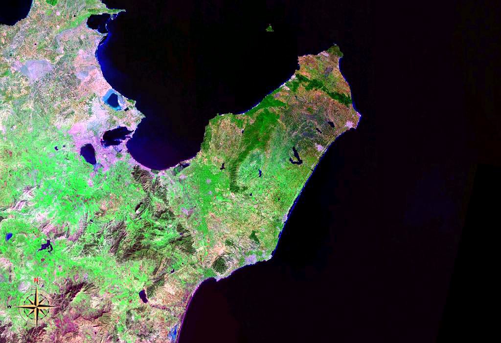
Cape Bon ("Good Cape"), also known as Res et-Teib (Arabic: الرأس الطيب), Shrīk Peninsula, or Watan el Kibli, is a peninsula in far northeastern Tunisia. Cape Bon is also the name of the northernmost point on the peninsula, also known as Res ed-Der, and known in antiquity as the Cape of Mercury (Latin: Promontorium Mercurii; Ancient Greek: Ερμαία ἄκρα) or Cape Hermaeum.
The peninsula's northern shore forms the southern end of the Gulf of Tunis, while its southern shore is on the Gulf of Hammamet.
The peninsula is administered as the country's Nabeul Governorate.
Settlements on the peninsula include Nabeul, Hammam el ghezaz, El Haouaria, Kelibia, Menzel Temime, Korba, and Beni Khalled. Rivers include the Melah and Chiba wadis. Mountains include Kef Bou Krim (237 m or 778 ft), Kef er-Rend (637 m or 2,090 ft), Djebel Sidi Abd er-Rahmane (602 m or 1,975 ft), Djebel Hofra (421 m or 1,381 ft), and Djebel Reba el-Aine (328 m or 1,076 ft). Besides Cape Bon, other headlands on the peninsula are Ras Dourdas and Ras el-Fortass on the northern shore, Ras el-Melah on the short eastern shore, and Ras Mostefa and Ras Maamoura on the southern shore.
The ruins of the Punic town Kerkouane are also located here. Djebel Mlezza ("Mount Mlessa") has tombs from the time of Agathocles, which were excavated just before the First World War.
Cape Bon
Cape Bon ("Good Cape"), also known as Res et-Teib (Arabic: الرأس الطيب), Shrīk Peninsula, or Watan el Kibli, is a peninsula in far northeastern Tunisia. Cape Bon is also the name of the northernmost point on the peninsula, also known as Res ed-Der, and known in antiquity as the Cape of Mercury (Latin: Promontorium Mercurii; Ancient Greek: Ερμαία ἄκρα) or Cape Hermaeum.
The peninsula's northern shore forms the southern end of the Gulf of Tunis, while its southern shore is on the Gulf of Hammamet.
The peninsula is administered as the country's Nabeul Governorate.
Settlements on the peninsula include Nabeul, Hammam el ghezaz, El Haouaria, Kelibia, Menzel Temime, Korba, and Beni Khalled. Rivers include the Melah and Chiba wadis. Mountains include Kef Bou Krim (237 m or 778 ft), Kef er-Rend (637 m or 2,090 ft), Djebel Sidi Abd er-Rahmane (602 m or 1,975 ft), Djebel Hofra (421 m or 1,381 ft), and Djebel Reba el-Aine (328 m or 1,076 ft). Besides Cape Bon, other headlands on the peninsula are Ras Dourdas and Ras el-Fortass on the northern shore, Ras el-Melah on the short eastern shore, and Ras Mostefa and Ras Maamoura on the southern shore.
The ruins of the Punic town Kerkouane are also located here. Djebel Mlezza ("Mount Mlessa") has tombs from the time of Agathocles, which were excavated just before the First World War.
Recent media
Recent media