Community hub
Recent from talks
Knowledge base stats:
Talk channels stats:
Members stats:
Cardo
A cardo (pl.: cardines) was a north–south street in ancient Roman cities and military camps as an integral component of city planning. The cardo maximus, or most often the cardo, was the main or central north–south-oriented street.
“Cardo” is the Latin word for "hinge". Being the hinge the turning point of the doors, the word cardo would also be used to designate other “turning points”, like the North Pole of the sky, or the four cardinal directions (quattuor cardines orbis terrarum). Also the “the principal line laid down in surveying land was called cardo", which is also applied to the first street of a city: the street around which the city would be structured.
Most Roman cities also had a decumanus maximus, an east–west street that served as a secondary main street. Due to varying geography, in some cities the decumanus is the main street and the cardo is secondary, but in general the cardo maximus served as the primary street. The forum was normally located at, or close to, the intersection of the decumanus and the cardo.
The cardo maximus of Apamea, Syria, ran through the centre of the city directly from North to South, linked the principal gates of the city, and was originally surrounded by 1,200 columns with unique spiral fluting, each subsequent column spiralling in the opposite direction. The thoroughfare was about 1.85 kilometres long and 37 metres wide, as it was used for wheeled transport. The great colonnade was erected in the 2nd century and it was still standing until the 12th. The earthquakes of 1157 and 1170 demolished the colonnade. The cardo was lined on both sides with civic and religious buildings.
Hohe Strasse and Schildergasse in Cologne, Germany, are examples of streets that have maintained their course and function of cardo and decumanus maximus to this day.
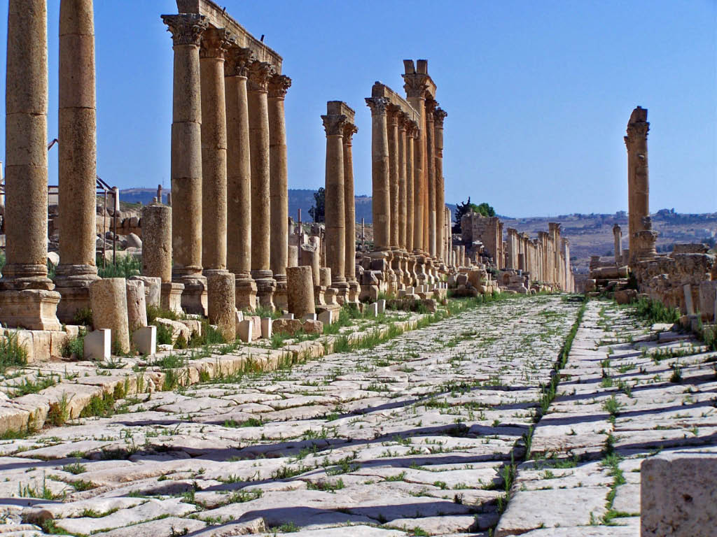
The excavations at Jerash, Jordan, have unearthed the remains of an ancient Roman city on the site, with the main feature of the city being a colonnaded cardo. The original road surface survived.
During the visit of Hadrian to Judea in the 130s AD, Jerusalem's ruins were surveyed, and Hadrian decided to build a Roman colony in its place, naming it Colonia Aelia Capitolina, after the Roman deities Jupiter, Juno and Minerva (the Capitoline Triad), worshiped at the Capitoline Hill temple in Rome. Like many Roman colonies, Aelia Capitolina was laid out with a Hippodamian grid plan of narrower streets and wider avenues. Notably, the decision was one of the main causes of the Bar Kokhba revolt, which shortly encompassed the region.
The main north–south thoroughfare, the cardo maximus, was originally a paved avenue approximately 22.5 meters wide (roughly the width of a six lane highway) which ran southward from the site of the Damascus Gate, terminating at an unknown point. The southern addition to the cardo, constructed under Justinian in the 6th century AD, extended the road further south to connect the Church of the Holy Sepulchre with the newly built Zion Gate. Along its length, the roadway was divided into three parts: two colonnaded covered walks flanking a 12 meter wide road. The shaded porticoes provided separation of pedestrian traffic from wheeled carts, shelter from the elements, space for small-scale commerce, as well as opportunities for residents and visitors to gather and interact. The central open pavement provided commercial access as well as ritual space. The cardo's most striking visual feature was its colonnade, clearly depicted on the Madaba Map.
Hub AI
Cardo AI simulator
(@Cardo_simulator)
Cardo
A cardo (pl.: cardines) was a north–south street in ancient Roman cities and military camps as an integral component of city planning. The cardo maximus, or most often the cardo, was the main or central north–south-oriented street.
“Cardo” is the Latin word for "hinge". Being the hinge the turning point of the doors, the word cardo would also be used to designate other “turning points”, like the North Pole of the sky, or the four cardinal directions (quattuor cardines orbis terrarum). Also the “the principal line laid down in surveying land was called cardo", which is also applied to the first street of a city: the street around which the city would be structured.
Most Roman cities also had a decumanus maximus, an east–west street that served as a secondary main street. Due to varying geography, in some cities the decumanus is the main street and the cardo is secondary, but in general the cardo maximus served as the primary street. The forum was normally located at, or close to, the intersection of the decumanus and the cardo.
The cardo maximus of Apamea, Syria, ran through the centre of the city directly from North to South, linked the principal gates of the city, and was originally surrounded by 1,200 columns with unique spiral fluting, each subsequent column spiralling in the opposite direction. The thoroughfare was about 1.85 kilometres long and 37 metres wide, as it was used for wheeled transport. The great colonnade was erected in the 2nd century and it was still standing until the 12th. The earthquakes of 1157 and 1170 demolished the colonnade. The cardo was lined on both sides with civic and religious buildings.
Hohe Strasse and Schildergasse in Cologne, Germany, are examples of streets that have maintained their course and function of cardo and decumanus maximus to this day.
The excavations at Jerash, Jordan, have unearthed the remains of an ancient Roman city on the site, with the main feature of the city being a colonnaded cardo. The original road surface survived.
During the visit of Hadrian to Judea in the 130s AD, Jerusalem's ruins were surveyed, and Hadrian decided to build a Roman colony in its place, naming it Colonia Aelia Capitolina, after the Roman deities Jupiter, Juno and Minerva (the Capitoline Triad), worshiped at the Capitoline Hill temple in Rome. Like many Roman colonies, Aelia Capitolina was laid out with a Hippodamian grid plan of narrower streets and wider avenues. Notably, the decision was one of the main causes of the Bar Kokhba revolt, which shortly encompassed the region.
The main north–south thoroughfare, the cardo maximus, was originally a paved avenue approximately 22.5 meters wide (roughly the width of a six lane highway) which ran southward from the site of the Damascus Gate, terminating at an unknown point. The southern addition to the cardo, constructed under Justinian in the 6th century AD, extended the road further south to connect the Church of the Holy Sepulchre with the newly built Zion Gate. Along its length, the roadway was divided into three parts: two colonnaded covered walks flanking a 12 meter wide road. The shaded porticoes provided separation of pedestrian traffic from wheeled carts, shelter from the elements, space for small-scale commerce, as well as opportunities for residents and visitors to gather and interact. The central open pavement provided commercial access as well as ritual space. The cardo's most striking visual feature was its colonnade, clearly depicted on the Madaba Map.