
Recent from talks
Census geographic units of Canada
Knowledge base stats:
Talk channels stats:
Members stats:
Census geographic units of Canada
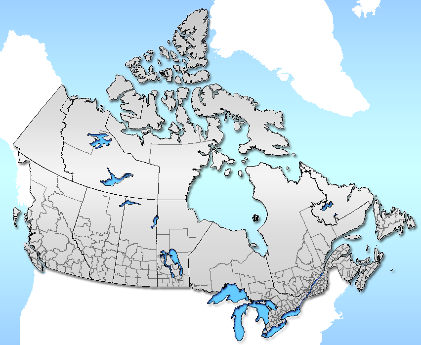
The census geographic units of Canada are the census subdivisions defined and used by Canada's federal government statistics bureau Statistics Canada to conduct the country's quinquennial census. These areas exist solely for the purposes of statistical analysis and presentation; they have no government of their own. They exist on four levels: the top-level (first-level) divisions are Canada's provinces and territories; these are divided into second-level census divisions, which in turn are divided into third-level census subdivisions (often corresponding to municipalities) and fourth-level dissemination areas.
In some provinces, census divisions correspond to the province's second-level administrative divisions such as a county or another similar unit of political organization. In the prairie provinces, census divisions do not correspond to the province's administrative divisions, but rather group multiple administrative divisions together. In Newfoundland and Labrador, the boundaries are set by Statistics Canada as no such level of government exists. Two of Canada's three territories are also divided into census divisions.
According to Statistics Canada, Census divisions "are intermediate geographic areas between the province/territory level and the municipality (census subdivision)." In six provinces, they are legislated groupings of adjacent census subdivisions (municipalities or municipal equivalents) that share in regional planning and management of certain services such as emergency response. In four provinces and all three territories, legislation for equivalent intermediate geographic areas do not exist. Statistics Canada therefore collaborates with the four provinces and three territories in the creation of statistical equivalents. Classifications of census divisions includes county, district, district municipality, region, regional county municipality, regional district, regional municipality, territory, territory equivalent, united counties, and simply census divisions.
A census consolidated subdivision is a geographic unit between census division and census subdivision. It is a combination of adjacent census subdivisions typically consisting of larger, more rural census subdivisions and smaller, more densely populated census subdivisions.
Census subdivisions generally correspond to the municipalities of Canada, as determined by provincial and territorial legislation. They can also correspond to area which are deemed to be equivalents to municipalities for statistical reporting purposes, such as Indian reserves, Indian settlements, and unorganized territories where municipal level government may not exist. Statistics Canada has created census subdivisions in cooperation with the provinces of British Columbia, Newfoundland and Labrador, and Nova Scotia as equivalents for municipalities. The Indian reserve and Indian settlement census subdivisions are determined according to criteria established by Indigenous and Northern Affairs Canada.
Dissemination areas are the smallest standard geographic unit in Canada and cover the entire country. As small areas, they comprise one or more dissemination blocks and have a population between 400 and 700 people.
A "census metropolitan area" (CMA) is a grouping of census subdivisions comprising a large urban area (the "urban core") and those surrounding "urban fringes" with which it is closely integrated. To become a CMA, an area must register an urban core population of at least 100,000 at the previous census. CMA status is retained even if this core population later drops below 100,000.
CMAs may cross census division and therefore provincial boundaries, although the Ottawa-Gatineau metropolitan area in Ontario and Quebec is the only one that currently crosses a provincial border.
Hub AI
Census geographic units of Canada AI simulator
(@Census geographic units of Canada_simulator)
Census geographic units of Canada
The census geographic units of Canada are the census subdivisions defined and used by Canada's federal government statistics bureau Statistics Canada to conduct the country's quinquennial census. These areas exist solely for the purposes of statistical analysis and presentation; they have no government of their own. They exist on four levels: the top-level (first-level) divisions are Canada's provinces and territories; these are divided into second-level census divisions, which in turn are divided into third-level census subdivisions (often corresponding to municipalities) and fourth-level dissemination areas.
In some provinces, census divisions correspond to the province's second-level administrative divisions such as a county or another similar unit of political organization. In the prairie provinces, census divisions do not correspond to the province's administrative divisions, but rather group multiple administrative divisions together. In Newfoundland and Labrador, the boundaries are set by Statistics Canada as no such level of government exists. Two of Canada's three territories are also divided into census divisions.
According to Statistics Canada, Census divisions "are intermediate geographic areas between the province/territory level and the municipality (census subdivision)." In six provinces, they are legislated groupings of adjacent census subdivisions (municipalities or municipal equivalents) that share in regional planning and management of certain services such as emergency response. In four provinces and all three territories, legislation for equivalent intermediate geographic areas do not exist. Statistics Canada therefore collaborates with the four provinces and three territories in the creation of statistical equivalents. Classifications of census divisions includes county, district, district municipality, region, regional county municipality, regional district, regional municipality, territory, territory equivalent, united counties, and simply census divisions.
A census consolidated subdivision is a geographic unit between census division and census subdivision. It is a combination of adjacent census subdivisions typically consisting of larger, more rural census subdivisions and smaller, more densely populated census subdivisions.
Census subdivisions generally correspond to the municipalities of Canada, as determined by provincial and territorial legislation. They can also correspond to area which are deemed to be equivalents to municipalities for statistical reporting purposes, such as Indian reserves, Indian settlements, and unorganized territories where municipal level government may not exist. Statistics Canada has created census subdivisions in cooperation with the provinces of British Columbia, Newfoundland and Labrador, and Nova Scotia as equivalents for municipalities. The Indian reserve and Indian settlement census subdivisions are determined according to criteria established by Indigenous and Northern Affairs Canada.
Dissemination areas are the smallest standard geographic unit in Canada and cover the entire country. As small areas, they comprise one or more dissemination blocks and have a population between 400 and 700 people.
A "census metropolitan area" (CMA) is a grouping of census subdivisions comprising a large urban area (the "urban core") and those surrounding "urban fringes" with which it is closely integrated. To become a CMA, an area must register an urban core population of at least 100,000 at the previous census. CMA status is retained even if this core population later drops below 100,000.
CMAs may cross census division and therefore provincial boundaries, although the Ottawa-Gatineau metropolitan area in Ontario and Quebec is the only one that currently crosses a provincial border.
Recent media