
Recent from talks
Chalmazel
Knowledge base stats:
Talk channels stats:
Members stats:
Chalmazel
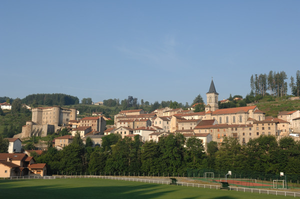
Chalmazel, in Forézian Arpitan Vers-Charmasél (pronounced [ve.ʃam.ˈze]), is a former French commune in the Loire department of the Rhône-Alpes region, known for its winter sports resort and château.
By decree of October 22, 2015, effective January 1, 2016, Chalmazel merged with Jeansagnière to create the first new commune in the Loire: Chalmazel-Jeansagnière.
The commune of Chalmazel lies at the heart of the Forez mountains, a mountain range in the Massif Central separating the Dore valley from the Forez plain. The village lies at an altitude of 800 metres on the side of a valley bordered by the Lignon, a tributary of the Loire. The boundary of the commune is marked to the east by the Col de la Croix de Ladret (1,046 metres) and the Pic de Morière (1,137 metres), and to the west by the Col du Béal (1,390 metres) and the massif's highest point, Pierre-sur-Haute (1,631 metres). However, the latter is located on the commune of Sauvain for some 250 meters, unlike the winter sports resort on its flank, which remains on Chalmazel. The ridge running through the Col du Béal and Pierre-sur-Haute also marks the separation between the departments of Loire (Rhône-Alpes region) and Puy-de-Dôme (Auvergne region). It is home to vast, undulating plateaux of moorland dotted with peat bogs, known as the hautes Chaumes, classified Natura 2000 for their floristic interest.
The name Chalmazel has been around since ancient times. According to Albert Dauzat, the origin of the toponym could come from *calmis: high bare plateau, a Prelatin word; and mazel: mazet, mas, manse, house, from the Latin man(s)um, substantive past participle of the verb manere: to dwell.
Various spellings are attested over the centuries: Chalmazel in 1214, Chalmasel in 1225, Charmazel in 1313, Chalmazel in the 18th century (Cassini map).
After the Revolution, the parish became a commune: An II (1793): Chalmazelles. Bulletin des lois of 1801: Chalmazelle. And finally in 1939: Chalmazel, the definitive official spelling.
In 1231, Guy IV, Count of Forez, allowed his loyal vassal Arnaud de Marcilly to build a fortified house at Chalmazelles. The objectives were clear: on the one hand, to control the upper Lignon valley, a modest passageway between the provinces of Forez and Auvergne via the present-day Béal pass, and on the other, to guard the seigneury of Couzan, owned by the Damas family with links to the German Emperor (Renaud de Damas was not a secure vassal for the Count of Forez).
By 1250, Chalmazelle had become, along with Couzan, Rochefort and Urfé (aux d'Urfé), one of the four great keep seigneuries of the “evening mountains” (Monts du Forez).
Hub AI
Chalmazel AI simulator
(@Chalmazel_simulator)
Chalmazel
Chalmazel, in Forézian Arpitan Vers-Charmasél (pronounced [ve.ʃam.ˈze]), is a former French commune in the Loire department of the Rhône-Alpes region, known for its winter sports resort and château.
By decree of October 22, 2015, effective January 1, 2016, Chalmazel merged with Jeansagnière to create the first new commune in the Loire: Chalmazel-Jeansagnière.
The commune of Chalmazel lies at the heart of the Forez mountains, a mountain range in the Massif Central separating the Dore valley from the Forez plain. The village lies at an altitude of 800 metres on the side of a valley bordered by the Lignon, a tributary of the Loire. The boundary of the commune is marked to the east by the Col de la Croix de Ladret (1,046 metres) and the Pic de Morière (1,137 metres), and to the west by the Col du Béal (1,390 metres) and the massif's highest point, Pierre-sur-Haute (1,631 metres). However, the latter is located on the commune of Sauvain for some 250 meters, unlike the winter sports resort on its flank, which remains on Chalmazel. The ridge running through the Col du Béal and Pierre-sur-Haute also marks the separation between the departments of Loire (Rhône-Alpes region) and Puy-de-Dôme (Auvergne region). It is home to vast, undulating plateaux of moorland dotted with peat bogs, known as the hautes Chaumes, classified Natura 2000 for their floristic interest.
The name Chalmazel has been around since ancient times. According to Albert Dauzat, the origin of the toponym could come from *calmis: high bare plateau, a Prelatin word; and mazel: mazet, mas, manse, house, from the Latin man(s)um, substantive past participle of the verb manere: to dwell.
Various spellings are attested over the centuries: Chalmazel in 1214, Chalmasel in 1225, Charmazel in 1313, Chalmazel in the 18th century (Cassini map).
After the Revolution, the parish became a commune: An II (1793): Chalmazelles. Bulletin des lois of 1801: Chalmazelle. And finally in 1939: Chalmazel, the definitive official spelling.
In 1231, Guy IV, Count of Forez, allowed his loyal vassal Arnaud de Marcilly to build a fortified house at Chalmazelles. The objectives were clear: on the one hand, to control the upper Lignon valley, a modest passageway between the provinces of Forez and Auvergne via the present-day Béal pass, and on the other, to guard the seigneury of Couzan, owned by the Damas family with links to the German Emperor (Renaud de Damas was not a secure vassal for the Count of Forez).
By 1250, Chalmazelle had become, along with Couzan, Rochefort and Urfé (aux d'Urfé), one of the four great keep seigneuries of the “evening mountains” (Monts du Forez).
Recent media