
Recent from talks
Camino Real de Tierra Adentro
Knowledge base stats:
Talk channels stats:
Members stats:
Camino Real de Tierra Adentro
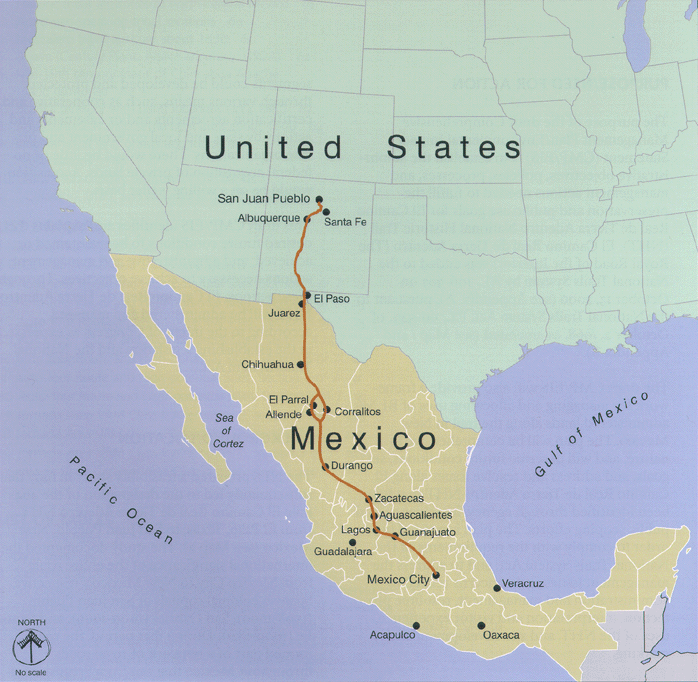
El Camino Real de Tierra Adentro (English: The Royal Road of the Interior Land), also known as the Silver Route, was a Spanish 2,560-kilometre-long (1,590 mi) road between Mexico City and San Juan Pueblo (Ohkay Owingeh), New Mexico (in the modern U.S.), that was used from 1598 to 1882. It was the northernmost of the four major "royal roads" that linked Mexico City to its major tributaries during and after the Spanish colonial era.
In 2010, 55 sites and five existing UNESCO World Heritage Sites along the Mexican section of the route were collectively added to the World Heritage List, including historic cities, towns, bridges, haciendas and other monuments along the 1,400-kilometre (870 mi) route between the Historic Center of Mexico City (also a World Heritage Site on its own) and the town of Valle de Allende, Chihuahua.
The 404-mile (650 km) section of the route within the United States was proclaimed the El Camino Real de Tierra Adentro National Historic Trail, a part of the National Historic Trail system, on October 13, 2000. The historic route is overseen by both the National Park Service and the U.S. Bureau of Land Management with aid from the El Camino Real de Tierra Adentro Trail Association (CARTA). A portion of the trail near San Acacia, New Mexico, was listed on the U.S. National Register of Historic Places in 2014.
The road is identified as beginning at the Plaza Santo Domingo very close to the present Zócalo and Mexico City Metropolitan Cathedral in Mexico City. Traveling north through San Miguel de Allende, Guanajuato, the road's northern terminus is located at Ohkay Owingeh, New Mexico.
Long before Europeans arrived, the various indigenous tribes and kingdoms that had arisen throughout the northern central steppe of Mexico had established the route that would later become the Camino Real de Tierra Adentro as a major thoroughfare for hunting and trading. The route connected the peoples of the Valley of Mexico with those of the north through the exchange of products such as turquoise, obsidian, salt and feathers. By the year AD 1000, a flourishing trade network existed from Mesoamerica to the Rocky Mountains.
After Tenochtitlan was subdued in 1521, Spanish conquistadors and colonists began a series of expeditions with the purpose of expanding their domains and obtaining greater wealth for the Spanish Crown. Their initial efforts led them to follow the trails established by the natives who exchanged goods between the north and the south.
In April 1598, a group of military scouts led by Juan de Oñate, the newly appointed colonial governor of the province of Santa Fe de Nuevo México, became lost in the desert south of Paso del Norte while seeking the best route to the Río del Norte. A local Indian they had captured named Mompil drew in the sand a map of the only safe passage to the river. The group arrived at the Río del Norte just south of present-day El Paso and Ciudad Juárez in late April, where they celebrated the Catholic Feast of the Ascension on April 30, before crossing the river. They then mapped and extended the route to what is now Española, where Oñate would establish the capital of the new province. This trail became the Camino Real de Tierra Adentro, the northernmost of the four main "royal roads" – the Caminos Reales – that linked Mexico City to its major tributaries in Acapulco, Veracruz, Audiencia (Guatemala) and Santa Fe.
After the Pueblo Revolt of 1680, which violently forced the Spanish out of Nuevo México, the Spanish Crown decided not to abandon the province altogether but instead maintained a channel to the province so as not to completely abandon their subjects remaining there. The Viceroyalty organized a system, the so-called conducta, to supply the missions, presidios, and northern ranchos. The conducta consisted of wagon caravans that departed every three years from Mexico City to Santa Fe along the Camino Real de Tierra Adentro. The trip required a long and difficult journey of six months, including 2–3 weeks of rest along the way.
Hub AI
Camino Real de Tierra Adentro AI simulator
(@Camino Real de Tierra Adentro_simulator)
Camino Real de Tierra Adentro
El Camino Real de Tierra Adentro (English: The Royal Road of the Interior Land), also known as the Silver Route, was a Spanish 2,560-kilometre-long (1,590 mi) road between Mexico City and San Juan Pueblo (Ohkay Owingeh), New Mexico (in the modern U.S.), that was used from 1598 to 1882. It was the northernmost of the four major "royal roads" that linked Mexico City to its major tributaries during and after the Spanish colonial era.
In 2010, 55 sites and five existing UNESCO World Heritage Sites along the Mexican section of the route were collectively added to the World Heritage List, including historic cities, towns, bridges, haciendas and other monuments along the 1,400-kilometre (870 mi) route between the Historic Center of Mexico City (also a World Heritage Site on its own) and the town of Valle de Allende, Chihuahua.
The 404-mile (650 km) section of the route within the United States was proclaimed the El Camino Real de Tierra Adentro National Historic Trail, a part of the National Historic Trail system, on October 13, 2000. The historic route is overseen by both the National Park Service and the U.S. Bureau of Land Management with aid from the El Camino Real de Tierra Adentro Trail Association (CARTA). A portion of the trail near San Acacia, New Mexico, was listed on the U.S. National Register of Historic Places in 2014.
The road is identified as beginning at the Plaza Santo Domingo very close to the present Zócalo and Mexico City Metropolitan Cathedral in Mexico City. Traveling north through San Miguel de Allende, Guanajuato, the road's northern terminus is located at Ohkay Owingeh, New Mexico.
Long before Europeans arrived, the various indigenous tribes and kingdoms that had arisen throughout the northern central steppe of Mexico had established the route that would later become the Camino Real de Tierra Adentro as a major thoroughfare for hunting and trading. The route connected the peoples of the Valley of Mexico with those of the north through the exchange of products such as turquoise, obsidian, salt and feathers. By the year AD 1000, a flourishing trade network existed from Mesoamerica to the Rocky Mountains.
After Tenochtitlan was subdued in 1521, Spanish conquistadors and colonists began a series of expeditions with the purpose of expanding their domains and obtaining greater wealth for the Spanish Crown. Their initial efforts led them to follow the trails established by the natives who exchanged goods between the north and the south.
In April 1598, a group of military scouts led by Juan de Oñate, the newly appointed colonial governor of the province of Santa Fe de Nuevo México, became lost in the desert south of Paso del Norte while seeking the best route to the Río del Norte. A local Indian they had captured named Mompil drew in the sand a map of the only safe passage to the river. The group arrived at the Río del Norte just south of present-day El Paso and Ciudad Juárez in late April, where they celebrated the Catholic Feast of the Ascension on April 30, before crossing the river. They then mapped and extended the route to what is now Española, where Oñate would establish the capital of the new province. This trail became the Camino Real de Tierra Adentro, the northernmost of the four main "royal roads" – the Caminos Reales – that linked Mexico City to its major tributaries in Acapulco, Veracruz, Audiencia (Guatemala) and Santa Fe.
After the Pueblo Revolt of 1680, which violently forced the Spanish out of Nuevo México, the Spanish Crown decided not to abandon the province altogether but instead maintained a channel to the province so as not to completely abandon their subjects remaining there. The Viceroyalty organized a system, the so-called conducta, to supply the missions, presidios, and northern ranchos. The conducta consisted of wagon caravans that departed every three years from Mexico City to Santa Fe along the Camino Real de Tierra Adentro. The trip required a long and difficult journey of six months, including 2–3 weeks of rest along the way.
Recent media