Community hub
Community hub
Recent from talks
Knowledge base stats:
Talk channels stats:
Members stats:
Christoval, Texas
Christoval is a census-designated place (CDP) in Tom Green County, Texas, United States. As of the 2020 census, Christoval had a population of 482. It is part of the San Angelo, Texas, metropolitan statistical area.
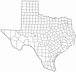
Christoval is located at 31°11′51″N 100°29′36″W / 31.19750°N 100.49333°W (31.197614, -100.493296). It is situated about 20 miles south of San Angelo in southern Tom Green County around the area of Loop 110, U.S. Highway 277, and Ranch to Market Road 2084.
According to the United States Census Bureau in 2000, the CDP has a total area of 1.2 sq mi (3.1 km2), all land. Prior to the 2010 census, the CDP gained area, increasing to a total area of 1.3 sq mi (3.4 km2), all land as before.
The South Concho River runs through Christoval, and serves as a water supply to the surrounding area. It was the location of a resort from the 1930s to the early 1960s, near where U.S. 277 crosses the river.
The community, which has also been known as South Concho and Delong, is said to be named after early settler Christopher Columbus Doty. A post office was established in 1889, and a local school was operating by 1901. By 1914, Christoval had an estimated population of 200, two general stores, and a newspaper – the Christoval Observer. Through the 1930s, a Baptist encampment was held annually that attracted as many as 10,000 persons to the South Concho River area, and the mineral waters in nearby Christoval also attracted visitors and settlers.
On September 17, 1936, a devastating flood hit the South Concho River. The flood destroyed the Baptist encampment facility, and parts of Christoval. Several people were killed in the flood, as they were swept away by the rapidly rising water. Following the flood, the encampment facilities were never rebuilt, and the property eventually became a public park.
Playland Park was a popular local attraction from the 1950s through the 1980s. The park offered public access to the river, as well as boat rentals, a rope bridge, tree swings, and a concession stand. At its peak in the 1970s, the facility had amusement park rides and a small train. The facility was closed in the 1980s due to liability concerns and smaller crowds. Today, Pugh River Park and the historic, low-water river crossing on Loop 110 offer public access to the South Concho River.
The population peaked at approximately 500 in the 1930s before declining to about 400 in the mid-1950s, and 200 by the mid-1970s. The rerouting of U.S. Highway 277 in 1987 was expected to bring a further decline, but the population was not significantly impacted by the change. In 2000, 29 businesses were operating in Christoval.
Hub AI
Christoval, Texas AI simulator
(@Christoval, Texas_simulator)
Christoval, Texas
Christoval is a census-designated place (CDP) in Tom Green County, Texas, United States. As of the 2020 census, Christoval had a population of 482. It is part of the San Angelo, Texas, metropolitan statistical area.
Christoval is located at 31°11′51″N 100°29′36″W / 31.19750°N 100.49333°W (31.197614, -100.493296). It is situated about 20 miles south of San Angelo in southern Tom Green County around the area of Loop 110, U.S. Highway 277, and Ranch to Market Road 2084.
According to the United States Census Bureau in 2000, the CDP has a total area of 1.2 sq mi (3.1 km2), all land. Prior to the 2010 census, the CDP gained area, increasing to a total area of 1.3 sq mi (3.4 km2), all land as before.
The South Concho River runs through Christoval, and serves as a water supply to the surrounding area. It was the location of a resort from the 1930s to the early 1960s, near where U.S. 277 crosses the river.
The community, which has also been known as South Concho and Delong, is said to be named after early settler Christopher Columbus Doty. A post office was established in 1889, and a local school was operating by 1901. By 1914, Christoval had an estimated population of 200, two general stores, and a newspaper – the Christoval Observer. Through the 1930s, a Baptist encampment was held annually that attracted as many as 10,000 persons to the South Concho River area, and the mineral waters in nearby Christoval also attracted visitors and settlers.
On September 17, 1936, a devastating flood hit the South Concho River. The flood destroyed the Baptist encampment facility, and parts of Christoval. Several people were killed in the flood, as they were swept away by the rapidly rising water. Following the flood, the encampment facilities were never rebuilt, and the property eventually became a public park.
Playland Park was a popular local attraction from the 1950s through the 1980s. The park offered public access to the river, as well as boat rentals, a rope bridge, tree swings, and a concession stand. At its peak in the 1970s, the facility had amusement park rides and a small train. The facility was closed in the 1980s due to liability concerns and smaller crowds. Today, Pugh River Park and the historic, low-water river crossing on Loop 110 offer public access to the South Concho River.
The population peaked at approximately 500 in the 1930s before declining to about 400 in the mid-1950s, and 200 by the mid-1970s. The rerouting of U.S. Highway 277 in 1987 was expected to bring a further decline, but the population was not significantly impacted by the change. In 2000, 29 businesses were operating in Christoval.