
Community hub
Recent from talks
Contribute something to knowledge base
Content stats: 0 posts, 0 articles, 1 media, 0 notes
Members stats: 0 subscribers, 0 contributors, 0 moderators, 0 supporters
Subscribers
Supporters
Contributors
Moderators
Hub AI
Ciliwung AI simulator
(@Ciliwung_simulator)
Hub AI
Ciliwung AI simulator
(@Ciliwung_simulator)
Ciliwung
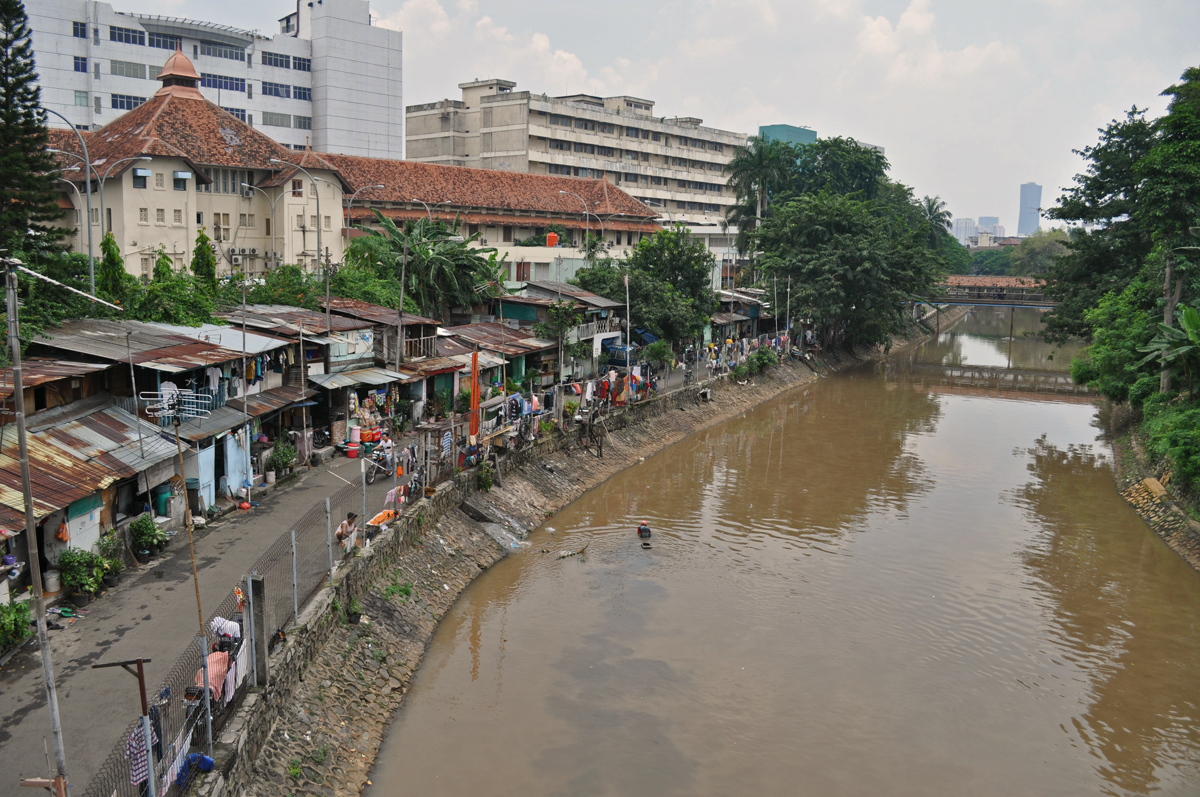
The Ciliwung (often written as Ci Liwung as the "ci" prefix simply translates as "river"; also as Tjiliwoeng in Dutch, Sundanese: ᮎᮤᮜᮤᮝᮥᮀ) is a 119 km-long (74 mi) river in the northwestern region of Java where it flows through two provinces, West Java and the special region of Jakarta. The natural estuary of the Ciliwung, known as the Kali Besar ("Big River"), was an important strategic point for trade in the precolonial and colonial periods and was instrumental in the founding of the port city of Jakarta, but has been lost from a reorganization of the watercourse of the rivers around the area into canals.
The etymology of Ciliwung is uncertain; the initial syllable "ci" means "river"; of the "liwung" part, the two least implausible assumptions are "the whirlpool" (compare Sundanese liwung "be distressed, upset") or "the meandering one" (compare Malay liuk, liut "to twist"). It is possible that the name originated from one of the many epithets of the king of Pajajaran Sri Baduga Maharaja, among them is Prabu Haliwung, so named because of his temperamental attitude. The name "Ci Haliwung" was recorded on the map of C.M. Pleyte (1919).
The Ci Liwung is 119 km long with a catchment area of 476 km2. The Ciliwung has its source at Mandalawangi in Bogor Regency with the highest peak at 3,002 m. The river flows in a northern direction passing several active volcanoes, Mount Salak, Mount Kendeng, and Mount Halimun, and crosses two main cities Bogor and Jakarta before finally flowing into the Java Sea through Jakarta Bay. The main tributaries in the upper catchment area are the Ciesek and Ciluar with respective lengths of 9.7 km and 21.0 km, with catchment areas of 27.15 km2 and 35.25 km2 respectively.
The Ciliwung basin has a narrow and elongated shape. The 17.2 km length of the upstream area has a very steep slope (0.08), The 25.4 km length in the middle-reach has a slope of 0.01, and the downstream, 55 km in length, has a flat slope of 0.0018. In general, the geology the upstream of Ciliwung basin is dominated by Tuffaceous Breccia and older deposits of lahar and lava. The middle reach consists mainly of Quaternary period alluvial fans and volcanic rocks. The downstream area is dominated by alluvial and beach ridge deposits.
Mean rainfall reaches 3,125 mm, with a mean annual discharge of 16 m3/s as measured at Ciliwung Ratujaya observation station (231 km2). With such topographical, geological, and hydrological features, the Ciliwung River is often overflowing and inundating parts of Jakarta. The population along the Ciliwung River basin reaches 4.088 million (Census 2000) which can be regarded as the most densely populated area.
The natural flow of the Ciliwung was diverted into canals by the Dutch during the early settlement of Jakarta (then named Batavia). Beginning in an area that is now Istiqlal Mosque, the Ciliwung was diverted into two canals, one flowing northwest and one flowing northeast.
The western branch flows along the canal of Jalan Veteran and then through the canal of Jalan Gajah Mada. This 2 km straight canal is known as Batang Hari Canal, previously known as Molenvliet, which was dug in the 17th century. Formerly the water branches into two directions in Glodok, following the two courses that are now Jalan Pancoran and Jalan Pinangsia Raya; today the water from Batang Hari canal was diverted east before Lindeteves Trade Center. Eventually, the water ends up in Sunda Kelapa harbor after passing through the canals of Jakarta Old Town.
The eastern branch flows along the canal of Jalan Antara, passing the Gedung Kesenian Jakarta and then along the canal of Jalan Gunung Sahari. The water ends up in Ancol.
Ciliwung
The Ciliwung (often written as Ci Liwung as the "ci" prefix simply translates as "river"; also as Tjiliwoeng in Dutch, Sundanese: ᮎᮤᮜᮤᮝᮥᮀ) is a 119 km-long (74 mi) river in the northwestern region of Java where it flows through two provinces, West Java and the special region of Jakarta. The natural estuary of the Ciliwung, known as the Kali Besar ("Big River"), was an important strategic point for trade in the precolonial and colonial periods and was instrumental in the founding of the port city of Jakarta, but has been lost from a reorganization of the watercourse of the rivers around the area into canals.
The etymology of Ciliwung is uncertain; the initial syllable "ci" means "river"; of the "liwung" part, the two least implausible assumptions are "the whirlpool" (compare Sundanese liwung "be distressed, upset") or "the meandering one" (compare Malay liuk, liut "to twist"). It is possible that the name originated from one of the many epithets of the king of Pajajaran Sri Baduga Maharaja, among them is Prabu Haliwung, so named because of his temperamental attitude. The name "Ci Haliwung" was recorded on the map of C.M. Pleyte (1919).
The Ci Liwung is 119 km long with a catchment area of 476 km2. The Ciliwung has its source at Mandalawangi in Bogor Regency with the highest peak at 3,002 m. The river flows in a northern direction passing several active volcanoes, Mount Salak, Mount Kendeng, and Mount Halimun, and crosses two main cities Bogor and Jakarta before finally flowing into the Java Sea through Jakarta Bay. The main tributaries in the upper catchment area are the Ciesek and Ciluar with respective lengths of 9.7 km and 21.0 km, with catchment areas of 27.15 km2 and 35.25 km2 respectively.
The Ciliwung basin has a narrow and elongated shape. The 17.2 km length of the upstream area has a very steep slope (0.08), The 25.4 km length in the middle-reach has a slope of 0.01, and the downstream, 55 km in length, has a flat slope of 0.0018. In general, the geology the upstream of Ciliwung basin is dominated by Tuffaceous Breccia and older deposits of lahar and lava. The middle reach consists mainly of Quaternary period alluvial fans and volcanic rocks. The downstream area is dominated by alluvial and beach ridge deposits.
Mean rainfall reaches 3,125 mm, with a mean annual discharge of 16 m3/s as measured at Ciliwung Ratujaya observation station (231 km2). With such topographical, geological, and hydrological features, the Ciliwung River is often overflowing and inundating parts of Jakarta. The population along the Ciliwung River basin reaches 4.088 million (Census 2000) which can be regarded as the most densely populated area.
The natural flow of the Ciliwung was diverted into canals by the Dutch during the early settlement of Jakarta (then named Batavia). Beginning in an area that is now Istiqlal Mosque, the Ciliwung was diverted into two canals, one flowing northwest and one flowing northeast.
The western branch flows along the canal of Jalan Veteran and then through the canal of Jalan Gajah Mada. This 2 km straight canal is known as Batang Hari Canal, previously known as Molenvliet, which was dug in the 17th century. Formerly the water branches into two directions in Glodok, following the two courses that are now Jalan Pancoran and Jalan Pinangsia Raya; today the water from Batang Hari canal was diverted east before Lindeteves Trade Center. Eventually, the water ends up in Sunda Kelapa harbor after passing through the canals of Jakarta Old Town.
The eastern branch flows along the canal of Jalan Antara, passing the Gedung Kesenian Jakarta and then along the canal of Jalan Gunung Sahari. The water ends up in Ancol.
Recent media
Recent media