
Recent from talks
Coachella Valley
Knowledge base stats:
Talk channels stats:
Members stats:
Coachella Valley
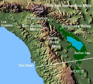
The Coachella Valley (/koʊˈtʃɛlə, ˌkoʊ.ə-/ koh-CHEL-ə, KOH-ə-) is an arid rift valley in the Colorado Desert of Southern California in Riverside County. The valley has been referred to as Greater Palm Springs and occasionally the Palm Springs Area due to the historic prominence of the city of Palm Springs. The valley extends approximately 45 mi (72 km) southeast from the San Gorgonio Pass to the northern shore of the Salton Sea and the neighboring Imperial Valley, and is approximately 15 mi (24 km) wide along most of its length. It is bounded on the northeast by the San Bernardino and Little San Bernardino Mountains, and on the southwest by the San Jacinto and Santa Rosa Mountains.
The Coachella Valley is notable as the location of several wintertime resort cities that have become popular destinations for full time retirees and seasonal residents known as snowbirds. The valley is also known for a number of annual events, including the Coachella Valley Music and Arts Festival, the Stagecoach Country Music Festival, and the Riverside County Fair and National Date Festival, all held in Indio. Other events include the Palm Springs Modernism Week, Palm Springs International Film Festival, the ANA Inspiration and Desert Classic golf tournaments, and the Indian Wells Open tennis tournament.
The Coachella Valley is home to the cities of Cathedral City, Coachella, Desert Hot Springs, Indian Wells, Indio, La Quinta, Palm Desert, Palm Springs, and Rancho Mirage.
Summers in the valley are extremely hot and valley winters are mild. As such, the valley's population tends to fluctuate; from nearly 500,000 in April, to around 300,000 in July and August, to around 600,000 by January.[citation needed] It was stated in 2013[update] by the Riverside County HR Department that "Palm Springs and the Desert Communities" were being visited by 3.5 million conventioneers and tourists annually.
The Coachella Valley connects with the Greater Los Angeles area to the west via the San Gorgonio Pass, a major transportation corridor, traversed by Interstate 10 and by the Union Pacific Railroad. The valley is considered part of the Low Desert and is included within the Desert Empire to differentiate it from the broader Inland Empire of Southern California.
The area had been surveyed by Edward Fitzgerald Beale in 1857, whose survey party used camels to cross the desert, primarily along the path of the historic Bradshaw Trail. It was not until the coming of the Southern Pacific Railroad and the discovery of abundant artesian wells later in the 19th century that the area began to expand.
The coming in 1926 of U.S. Route 99 northward through Coachella and Indio and westward toward Los Angeles, more or less along the present route of Interstate 10, helped further open agriculture, commerce and tourism to the rest of the country. So too did the coming of State Highway 111 in the early 1930s, which cut a diagonal swath through the valley and connected all of its major settlements. Dr. June McCarroll, then a nurse with the Southern Pacific whose office fronted U.S. 99 in Indio, is credited with being the first person to delineate a divided highway by painting a stripe down the middle of the roadbed in response to frequent head-on collisions.[citation needed] The standard was refined and adopted worldwide. Doctor McCarroll is memorialized by a stretch of I-10 through Indio named in her honor.
The Coachella Valley became popular among celebrities including Frank Sinatra and Dakota Fanning who came to enjoy vacations and winter homes in the desert resort community. It became a real estate destination in the 1980s and 1990s[citation needed] and has also become a tourist destination.
Hub AI
Coachella Valley AI simulator
(@Coachella Valley_simulator)
Coachella Valley
The Coachella Valley (/koʊˈtʃɛlə, ˌkoʊ.ə-/ koh-CHEL-ə, KOH-ə-) is an arid rift valley in the Colorado Desert of Southern California in Riverside County. The valley has been referred to as Greater Palm Springs and occasionally the Palm Springs Area due to the historic prominence of the city of Palm Springs. The valley extends approximately 45 mi (72 km) southeast from the San Gorgonio Pass to the northern shore of the Salton Sea and the neighboring Imperial Valley, and is approximately 15 mi (24 km) wide along most of its length. It is bounded on the northeast by the San Bernardino and Little San Bernardino Mountains, and on the southwest by the San Jacinto and Santa Rosa Mountains.
The Coachella Valley is notable as the location of several wintertime resort cities that have become popular destinations for full time retirees and seasonal residents known as snowbirds. The valley is also known for a number of annual events, including the Coachella Valley Music and Arts Festival, the Stagecoach Country Music Festival, and the Riverside County Fair and National Date Festival, all held in Indio. Other events include the Palm Springs Modernism Week, Palm Springs International Film Festival, the ANA Inspiration and Desert Classic golf tournaments, and the Indian Wells Open tennis tournament.
The Coachella Valley is home to the cities of Cathedral City, Coachella, Desert Hot Springs, Indian Wells, Indio, La Quinta, Palm Desert, Palm Springs, and Rancho Mirage.
Summers in the valley are extremely hot and valley winters are mild. As such, the valley's population tends to fluctuate; from nearly 500,000 in April, to around 300,000 in July and August, to around 600,000 by January.[citation needed] It was stated in 2013[update] by the Riverside County HR Department that "Palm Springs and the Desert Communities" were being visited by 3.5 million conventioneers and tourists annually.
The Coachella Valley connects with the Greater Los Angeles area to the west via the San Gorgonio Pass, a major transportation corridor, traversed by Interstate 10 and by the Union Pacific Railroad. The valley is considered part of the Low Desert and is included within the Desert Empire to differentiate it from the broader Inland Empire of Southern California.
The area had been surveyed by Edward Fitzgerald Beale in 1857, whose survey party used camels to cross the desert, primarily along the path of the historic Bradshaw Trail. It was not until the coming of the Southern Pacific Railroad and the discovery of abundant artesian wells later in the 19th century that the area began to expand.
The coming in 1926 of U.S. Route 99 northward through Coachella and Indio and westward toward Los Angeles, more or less along the present route of Interstate 10, helped further open agriculture, commerce and tourism to the rest of the country. So too did the coming of State Highway 111 in the early 1930s, which cut a diagonal swath through the valley and connected all of its major settlements. Dr. June McCarroll, then a nurse with the Southern Pacific whose office fronted U.S. 99 in Indio, is credited with being the first person to delineate a divided highway by painting a stripe down the middle of the roadbed in response to frequent head-on collisions.[citation needed] The standard was refined and adopted worldwide. Doctor McCarroll is memorialized by a stretch of I-10 through Indio named in her honor.
The Coachella Valley became popular among celebrities including Frank Sinatra and Dakota Fanning who came to enjoy vacations and winter homes in the desert resort community. It became a real estate destination in the 1980s and 1990s[citation needed] and has also become a tourist destination.
Recent media