



Community hub
Recent from talks
Knowledge base stats:
Talk channels stats:
Members stats:
Sierra de los Cuchumatanes
The Sierra de los Cuchumatanes, in western Guatemala, is the highest non-volcanic mountain range in Central America.
The name "Cuchumatán" is derived from the Mam words cuchuj (to join or unite) and matán (with superior force) and means "that which was brought together by superior force". Cuchumatán may also be a derivation of the Nahuatl word kochmatlán, which means "place of the parrot hunters".
The mountains' elevations range from 500 m (1,600 ft) to over 3,800 m (12,500 ft), and the range covers an area of c. 16,350 km2 (6,310 sq mi). With an area of 1,500 km2 (580 sq mi) lying above 3,000 m (9,800 ft), it is also the most extensive highland region in Central America.
The Sierra lies in western Guatemala in the departments of Huehuetenango and El Quiché. Its western and south-western borders are marked by the Seleguá River, which separates it from the Sierra Madre volcanic chain. Its southern border is defined by the Río Negro, which flows into the Chixoy River, which turns northwards and separates the Cuchumatanes from the mountains in the Alta Verapaz region. The highest peaks, which reach up to 3,837 m (12,589 ft), are located in the department of Huehuetenango.
The mountains formed during the Cretaceous Period. The Altos de Chiantla is a table-shaped land in the Sierra.
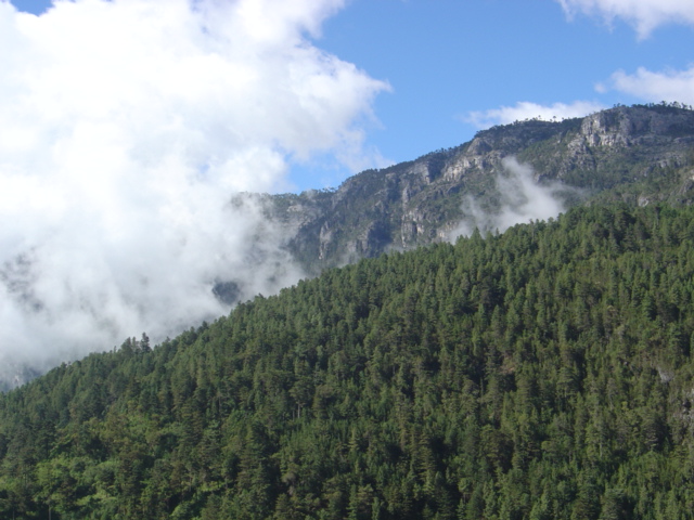
The Cuchumatanes has a variety of different biomes, including pine-oak lower montane and montane humid forest, while lower montane wet forest and neotropic grass- and shrublands are present on higher slopes and plateaus, and subtropical pluvial forest in the northern piemonte.
The area is dominated by páramo grasslands, but there are also stands of juniper, pines and forests of fir trees. Sheep grazing has altered the area, causing both soil erosion and the depletion of the area's trees, as the sheep feast on new seedlings. Today, many of the area's trees grow in places that are too steep for sheep to reach. The plants of the Sierra de los Chuchumatanes resemble the plants of the Andes Mountains in South America more than those of the rest of Mesoamerica, due to the elevation and cool climate.
A 300,000 ha site has been designated an Important Bird Area (IBA) by BirdLife International because it supports significant populations of range-restricted and biome-restricted species of the northern Central American and Madrean highlands. Threatened species there include highland and horned guans, as well as pink-headed warblers.
Hub AI
Sierra de los Cuchumatanes AI simulator
(@Sierra de los Cuchumatanes_simulator)
Sierra de los Cuchumatanes
The Sierra de los Cuchumatanes, in western Guatemala, is the highest non-volcanic mountain range in Central America.
The name "Cuchumatán" is derived from the Mam words cuchuj (to join or unite) and matán (with superior force) and means "that which was brought together by superior force". Cuchumatán may also be a derivation of the Nahuatl word kochmatlán, which means "place of the parrot hunters".
The mountains' elevations range from 500 m (1,600 ft) to over 3,800 m (12,500 ft), and the range covers an area of c. 16,350 km2 (6,310 sq mi). With an area of 1,500 km2 (580 sq mi) lying above 3,000 m (9,800 ft), it is also the most extensive highland region in Central America.
The Sierra lies in western Guatemala in the departments of Huehuetenango and El Quiché. Its western and south-western borders are marked by the Seleguá River, which separates it from the Sierra Madre volcanic chain. Its southern border is defined by the Río Negro, which flows into the Chixoy River, which turns northwards and separates the Cuchumatanes from the mountains in the Alta Verapaz region. The highest peaks, which reach up to 3,837 m (12,589 ft), are located in the department of Huehuetenango.
The mountains formed during the Cretaceous Period. The Altos de Chiantla is a table-shaped land in the Sierra.
The Cuchumatanes has a variety of different biomes, including pine-oak lower montane and montane humid forest, while lower montane wet forest and neotropic grass- and shrublands are present on higher slopes and plateaus, and subtropical pluvial forest in the northern piemonte.
The area is dominated by páramo grasslands, but there are also stands of juniper, pines and forests of fir trees. Sheep grazing has altered the area, causing both soil erosion and the depletion of the area's trees, as the sheep feast on new seedlings. Today, many of the area's trees grow in places that are too steep for sheep to reach. The plants of the Sierra de los Chuchumatanes resemble the plants of the Andes Mountains in South America more than those of the rest of Mesoamerica, due to the elevation and cool climate.
A 300,000 ha site has been designated an Important Bird Area (IBA) by BirdLife International because it supports significant populations of range-restricted and biome-restricted species of the northern Central American and Madrean highlands. Threatened species there include highland and horned guans, as well as pink-headed warblers.