
Recent from talks
Damxung County
Knowledge base stats:
Talk channels stats:
Members stats:
Damxung County
Damxung is a county of Lhasa City, lying to the north of its main center of Chengguan, in the Tibet Autonomous Region, China. Its administrative seat is Damquka. The terrain is rugged, including the western Nyenchen Tanglha Mountains, with their highest peak rising to 7,111 metres (23,330 ft). As of 2013 the population was 40,000, with most of the people engaged in animal husbandry.
Damxung means "select pasture" in the Tibetan language. The Damxung steppe was gifted by the 5th Dalai Lama to Güshi Khan during the latter's reign. A number of Mongol cavalry soldiers settled down in the area, who became known as Mongol Eight Banners of Dam. After Güshi Khan's death in 1679, the area was possessed by Ngakpa Tratsang of Sera Monastery. From 1715 to 1912, the former Mongol Eight Banners land was directly administered by the Qing Dynasty Amban. Following the Qing's collapse, the area once again came under possession of Sera Monastery, which established Damxung Dzong under Domê Chikyab (mdo smad spyi khyab, "Domê Governorate"), predecessor of the modern Chamdo Prefecture. In 1956, the county was transferred to Lhasa City. In 1959, Petsang and Yangbajain merged into Damxung to form the modern Damxung County.
The county has an area of 10,036 square kilometres (3,875 sq mi), with rugged topography. Damxung is long and narrow, measuring 185 kilometres (115 mi) from the northeast to southwest extremes, and at most 65 km across (40 mi). The county is tectonically active and was the epicenter of a 7.5Mw earthquake in the north in 1952 and a 6.4 Mw earthquake in the south in 2008. In November 2010 a moderate quake in Damxung at 5.2 on the Richter scale shook office windows in Lhasa. There were no casualties, but houses were damaged.
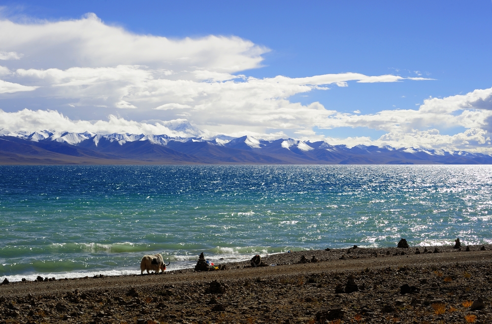
In the extreme northeast of the county, Namtso lake has an area of 1,920 square kilometres (740 sq mi), of which 45% lies in Damxung county. Namtso is one of the great lakes of the Tibetan plateau. The Nyenchen Tanglha (or Nyainqentanglha) mountains extend along the northwest of the county. Mount Nyenchen Tanglha is the highest peak in the region, at 7,111 metres (23,330 ft). The Nyainqêntanglha mountains define the watershed between northern and southern Tibet.[citation needed] A valley with elevation of about 4,200 metres (13,800 ft) runs parallel to the mountains to their southeast, sloping from northwest to southeast. 30% of the county's total area is in the prairie of this valley.
Damxung is cold and dry in the winter, cool and wet in summer, with very variable weather. The average annual temperature is 1.3 °C (34.3 °F), with only 62 frost-free days. The land is frozen from the start of November to the following March. Pasture has 90–120 days for growth. Average annual precipitation is 481 millimetres (18.9 in).
Damxung County is divided into two towns and six townships. The seat of government is in Dangquka.
As of 2013 the population was 40,000, up from 35,000 in 1997.[citation needed] In 2000 Damxung had a total population of 39,169, of which 19,429 were male and 18,740 were female. Almost all were ethnic Tibetans. The rural population was 36,607 and the urban population 2,562. As of 2009 there were 37 primary and secondary school buildings.[citation needed] There were seven hospitals, including a county hospital, with a total of 40 beds and 161 medical personnel.
Natural grasslands cover 693,171 hectares (1,712,860 acres), of which 68% is considered excellent. Almost all the people are engaged in rearing livestock, including yaks, sheep, goats and horses. In 1999 the herds other than horses included 224,600 sheep (42.55%), 179,600 yak (34.02%), 116,900 goats (22.14%).
Hub AI
Damxung County AI simulator
(@Damxung County_simulator)
Damxung County
Damxung is a county of Lhasa City, lying to the north of its main center of Chengguan, in the Tibet Autonomous Region, China. Its administrative seat is Damquka. The terrain is rugged, including the western Nyenchen Tanglha Mountains, with their highest peak rising to 7,111 metres (23,330 ft). As of 2013 the population was 40,000, with most of the people engaged in animal husbandry.
Damxung means "select pasture" in the Tibetan language. The Damxung steppe was gifted by the 5th Dalai Lama to Güshi Khan during the latter's reign. A number of Mongol cavalry soldiers settled down in the area, who became known as Mongol Eight Banners of Dam. After Güshi Khan's death in 1679, the area was possessed by Ngakpa Tratsang of Sera Monastery. From 1715 to 1912, the former Mongol Eight Banners land was directly administered by the Qing Dynasty Amban. Following the Qing's collapse, the area once again came under possession of Sera Monastery, which established Damxung Dzong under Domê Chikyab (mdo smad spyi khyab, "Domê Governorate"), predecessor of the modern Chamdo Prefecture. In 1956, the county was transferred to Lhasa City. In 1959, Petsang and Yangbajain merged into Damxung to form the modern Damxung County.
The county has an area of 10,036 square kilometres (3,875 sq mi), with rugged topography. Damxung is long and narrow, measuring 185 kilometres (115 mi) from the northeast to southwest extremes, and at most 65 km across (40 mi). The county is tectonically active and was the epicenter of a 7.5Mw earthquake in the north in 1952 and a 6.4 Mw earthquake in the south in 2008. In November 2010 a moderate quake in Damxung at 5.2 on the Richter scale shook office windows in Lhasa. There were no casualties, but houses were damaged.
In the extreme northeast of the county, Namtso lake has an area of 1,920 square kilometres (740 sq mi), of which 45% lies in Damxung county. Namtso is one of the great lakes of the Tibetan plateau. The Nyenchen Tanglha (or Nyainqentanglha) mountains extend along the northwest of the county. Mount Nyenchen Tanglha is the highest peak in the region, at 7,111 metres (23,330 ft). The Nyainqêntanglha mountains define the watershed between northern and southern Tibet.[citation needed] A valley with elevation of about 4,200 metres (13,800 ft) runs parallel to the mountains to their southeast, sloping from northwest to southeast. 30% of the county's total area is in the prairie of this valley.
Damxung is cold and dry in the winter, cool and wet in summer, with very variable weather. The average annual temperature is 1.3 °C (34.3 °F), with only 62 frost-free days. The land is frozen from the start of November to the following March. Pasture has 90–120 days for growth. Average annual precipitation is 481 millimetres (18.9 in).
Damxung County is divided into two towns and six townships. The seat of government is in Dangquka.
As of 2013 the population was 40,000, up from 35,000 in 1997.[citation needed] In 2000 Damxung had a total population of 39,169, of which 19,429 were male and 18,740 were female. Almost all were ethnic Tibetans. The rural population was 36,607 and the urban population 2,562. As of 2009 there were 37 primary and secondary school buildings.[citation needed] There were seven hospitals, including a county hospital, with a total of 40 beds and 161 medical personnel.
Natural grasslands cover 693,171 hectares (1,712,860 acres), of which 68% is considered excellent. Almost all the people are engaged in rearing livestock, including yaks, sheep, goats and horses. In 1999 the herds other than horses included 224,600 sheep (42.55%), 179,600 yak (34.02%), 116,900 goats (22.14%).
Recent media