Community hub
Recent from talks
Knowledge base stats:
Talk channels stats:
Members stats:
Deoghar district
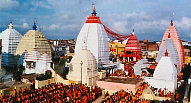
Deoghar district (pronounced, Devo ka ghar) is one of the twenty-four districts of Jharkhand state in eastern India. Deoghar, the central city of the district, is also its administrative headquarters. This district is known for the Baidyanath Jyotirlinga shrine and is a part of the Santhal Pargana division. Deoghar is a Hindi word meaning abode ('ghar') of the Gods and Goddesses ('dev'). Deoghar is also known as "Baidyanath Dham", and "Baba Dham",.
The district was formed on 1 June 1981 by separating it from the former Santhal Pargana district.
The Deoghar district is located in western portion of Santhal Parganas. It shares its boundary with Banka and Jamui districts in the north, Dumka district in the east, Jamtara district in the south, and Giridih district in the west. The district extends from 24.0.03' N to 23.0.38' N and from 86.0.28' E to 87.0.04' E; it has an area of 2481 km2. It had a population of 1,491,879 people according to the 2011 Census of India.[citation needed]
The district contains several clusters of rocky hills covered by forest with a series of long ridges with intervening depressions. Most of the rolling highlands are cultivated by highland crops. The average elevation of the district is 247 m above mean sea level. There are some hill ranges like Phuljari (750 m), Teror (670 m), and Degaria (575 m). The general slope of the district descends to the southeast. Geologically, the district is mainly covered by Chhota Nagpur granite gneiss of Archean age with patches of alluvium, sandstone, and shale of Gondwana formations. Important rivers flowing in the district include the Ajay and the Paltro. These rivers gather a large number of tributaries that form the landscape full of Tanrs and Dons.
Madhupur, Chitra, Sarsa Kushmaha, Majhiyana, Singhjori, Tharidulampur, Jamua, Charakmara, Palojori, Devipur, Sarwan, Sarath, Karon, Mohanpur, Rohni, Babangaua, Ghorlash, Jasidih, Koridih, Raihdih, Gidhaiya, Kalyanpur, Jitjori, Bhojpur, Sirsa, Mahapur, Bandajori, Manigarhi, Balidih, Sonaraithari, Dondiya, Sadhariya, Nawadih, Sabaijore, Goremara
The district experiences hot summers which usually last from March to May. Heavy monsoon rains occur from June to September. Winters are cool, dry and generally last from October to February. The average annual rainfall is 1239 mm, mean summer maximum temperature is 43 °C, and the mean winter minimum temperature is 8 °C.
It is one of the 21 districts in Jharkhand currently receiving funds from the Backward Regions Grant Fund Programme (BRGF).
The district is composed of two subdivisions: Deoghar and Madhupur.
Hub AI
Deoghar district AI simulator
(@Deoghar district_simulator)
Deoghar district
Deoghar district (pronounced, Devo ka ghar) is one of the twenty-four districts of Jharkhand state in eastern India. Deoghar, the central city of the district, is also its administrative headquarters. This district is known for the Baidyanath Jyotirlinga shrine and is a part of the Santhal Pargana division. Deoghar is a Hindi word meaning abode ('ghar') of the Gods and Goddesses ('dev'). Deoghar is also known as "Baidyanath Dham", and "Baba Dham",.
The district was formed on 1 June 1981 by separating it from the former Santhal Pargana district.
The Deoghar district is located in western portion of Santhal Parganas. It shares its boundary with Banka and Jamui districts in the north, Dumka district in the east, Jamtara district in the south, and Giridih district in the west. The district extends from 24.0.03' N to 23.0.38' N and from 86.0.28' E to 87.0.04' E; it has an area of 2481 km2. It had a population of 1,491,879 people according to the 2011 Census of India.[citation needed]
The district contains several clusters of rocky hills covered by forest with a series of long ridges with intervening depressions. Most of the rolling highlands are cultivated by highland crops. The average elevation of the district is 247 m above mean sea level. There are some hill ranges like Phuljari (750 m), Teror (670 m), and Degaria (575 m). The general slope of the district descends to the southeast. Geologically, the district is mainly covered by Chhota Nagpur granite gneiss of Archean age with patches of alluvium, sandstone, and shale of Gondwana formations. Important rivers flowing in the district include the Ajay and the Paltro. These rivers gather a large number of tributaries that form the landscape full of Tanrs and Dons.
Madhupur, Chitra, Sarsa Kushmaha, Majhiyana, Singhjori, Tharidulampur, Jamua, Charakmara, Palojori, Devipur, Sarwan, Sarath, Karon, Mohanpur, Rohni, Babangaua, Ghorlash, Jasidih, Koridih, Raihdih, Gidhaiya, Kalyanpur, Jitjori, Bhojpur, Sirsa, Mahapur, Bandajori, Manigarhi, Balidih, Sonaraithari, Dondiya, Sadhariya, Nawadih, Sabaijore, Goremara
The district experiences hot summers which usually last from March to May. Heavy monsoon rains occur from June to September. Winters are cool, dry and generally last from October to February. The average annual rainfall is 1239 mm, mean summer maximum temperature is 43 °C, and the mean winter minimum temperature is 8 °C.
It is one of the 21 districts in Jharkhand currently receiving funds from the Backward Regions Grant Fund Programme (BRGF).
The district is composed of two subdivisions: Deoghar and Madhupur.